Bryan Norcross: Reflecting on hurricane season 2025
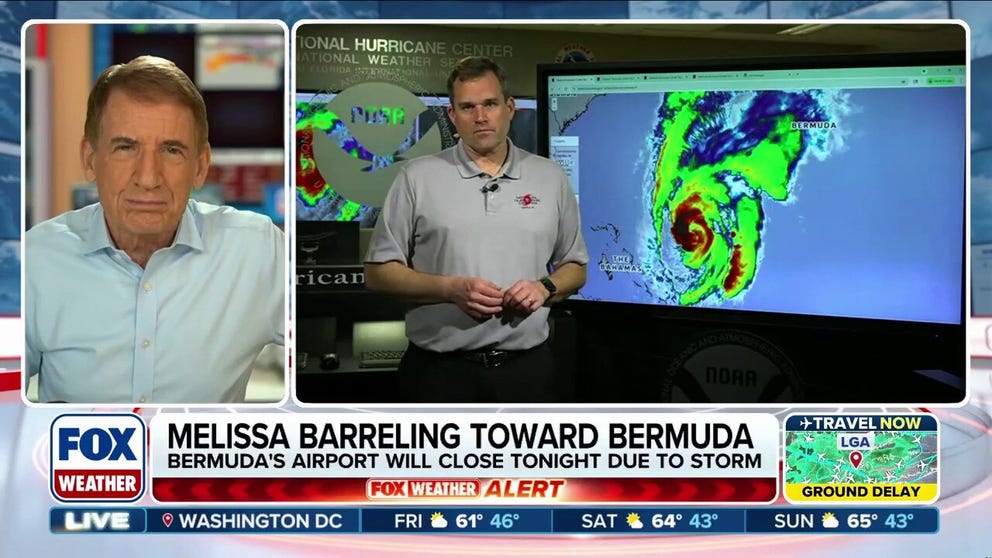
Norcross and Brennan discuss how Hurricane Melissa may even be more historic than previously thought, and what’s next for the storm as it races to swing by Bermuda.
Updated as of 9:30 AM E.T. on Monday, November 10
Further tropical development is unlikely this hurricane season. A wintertime weather pattern has settled over the Gulf, the Caribbean, and the tropical Atlantic. Hostile upper-level winds and dry air blanket the tropical zone.
A fluke tropical storm can theoretically develop at any time during the year, and there’s at least one in the record book in every month. But the odds are high that we’ll get through November without any development.
NOAA’s Climate Prediction Center generates a long-range tropical forecast. The latest one, which runs through November 25, shows no tropical development, although it does predict an area of higher-than-normal rainfall in the western Caribbean, which is not unusual. The western Pacific, including the Philippines, is the focus area for storm formation right now.

Map of Atlantic basin showing no signs of tropical development
(FOX Weather)
Takeaways from Hurricane Season 2025
I have three big takeaways from this hurricane season. The first, of course, is the incredible meteorological spectacle that was Hurricane Melissa – and its catastrophic consequences.
Melissa’s strength at landfall will be meticulously analyzed by the National Hurricane Center. They will issue a final report next year. It’s rare to see a tropical system so purely symmetrical. Super Typhoon Haiyan, which devastated part of the central Philippines and had winds estimated at 195 mph, comes to mind.
Whatever the final numbers are, they will be as high as or higher than any landfalling Atlantic hurricane on record. That’s interesting meteorologically, of course, but of little comfort to the people in the western half of Jamaica. Unfortunately, like the northern Bahamas, which was relentlessly pounded by 185 mph Hurricane Dorian in 2019, recovery is going to take many years.
My second big takeaway is the incredible success of the AI computer models, and specifically the Google DeepMind model. This is the first season that we used and evaluated these next-generation forecasting systems in day-to-day operations. The results have been stunning.

Tropical outlook graphic
(FOX Weather)
The Google model produced the best track forecasts at most time periods by training its model with historical hurricane data plus high-resolution data from more recent storms. At the beginning of the season, we were all wondering if AI modeling – which many dismissed as simply pattern matching – would add value. The answer was a resounding yes.
Indeed, the AI systems specifically tailored to a given task use pattern matching to predict the future. But they do much more. In hard-to-define ways, they also do something we might describe as thinking. They sometimes deduce outcomes that don’t exist in their training data.
There is still much to learn about how they work, and what can be done to further improve their performance.
Google’s intensity forecasts were better than most of our other computer modeling systems as well. By the time Hurricane Melissa came around, the National Hurricane Center was routinely deferring to Google DeepMind’s model in making its forecasts.
Traditionally, the best forecasts are made by calculating a smart average of a set of key computer model forecasts. It will be interesting to see if, in the final analysis, a new averaging scheme that incorporates the Google model will be superior, or if the traditional models simply provide less value. In any case, it was an incredible technological step forward.
In full disclosure, I had a small role working with Google DeepMind on the public interface for the model, though the technological achievements were fully made by the Google scientists.
And my third takeaway from the season was more amusement than anything else. Many online comments and people I’ve met have expressed something akin to surprise that no hurricanes made landfall in the U.S. this season. It’s actually quite common to get through a season without a hurricane landfall. It just hasn’t happened in the last 10 years.
Looking back over 25 years, about a quarter of the seasons have been hurricane-landfall-free. Going back 75 years, the number is about 21%. So on average, we should avoid landfalls every four or five years.
It doesn’t work out that way in practice, of course. Landfall-free years tend to come in clumps when the steering pattern over the U.S. tends to push storms away. Also, a number of the years with no technical hurricane landfalls featured destructive impacts. In 2001, for example, Tropical Storm Allison caused a multi-billion-dollar flood in Houston.
Some seasons without landfalling hurricanes were busy, and some were quiet.
While seasonal forecasts can be accurate in broad strokes—generally, this season was not expected to be hyperactive—the weather pattern can only be predicted a week or two in advance. And it’s the weather pattern that steers storms one way or the other.

NOAA prediction for August 2025 graphic
(FOX Weather)
Here’s NOAA’s final 2025 prediction from August. The final total of 13 named storms, 5 hurricanes, with 4 of them reaching Category 3 and above was within their forecast ranges – barely. So the gist was right.
Of course, the seasonal predictions didn’t hint, nor could they, that three of the hurricanes would reach Cat 5.
A caveat when we talk about hurricane seasons of the past. We don’t know if one weather pattern or the other might be more likely in a warmer world.
Is the atmospheric randomness of the past the same as the randomness of this era? Or might atmospheric biases have shifted, meaning that a jet stream pattern conducive to U.S. landfalls is more or less likely going forward? We’ll see.
For now, let’s take the win. And remember our friends in Jamaica, Cuba, and the islands affected by Super-Hurricane Melissa.
Source link
editor's pick
latest video
Sports News To You
Subscribe to receive daily sports scores, hot takes, and breaking news!