Bryan Norcross: Standing by for Tropical Storm Gabrielle in Atlantic

FOX Weather is your Hurricane HQ
(FOX Weather)
Updated at 9:30 a.m. ET on Tuesday, Sept. 16, 2025
It’s extremely unusual to have no named tropical systems in the first half of September, and even weirder that the pause began in August. Since satellites began monitoring the Atlantic in the 1960s, the only year that was somewhat comparable was the very slow hurricane season in 1968. The only hurricane stronger than Category 1 that year was Hurricane Gladys that hit Florida north of Tampa as a Cat 2 in December.
In 2025, the Atlantic, the Caribbean and the Gulf continue to be generally hostile to tropical development, although it looks like a supportive slot will develop in the central Atlantic that will allow Gabrielle to form and intensify later this week.
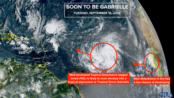
This satellite image provides additional information on Invest 92L in the Atlantic.
(FOX Weather)
The National Hurricane Center has the odds in the very high category that the tropical disturbance, Invest 92L, will develop into a tropical depression or Tropical Storm Gabrielle. The system has been fighting off dust and dry air, but the strong consensus of the computer forecast models is that the developing large circulation will soon sufficiently organize to get the depression designation.
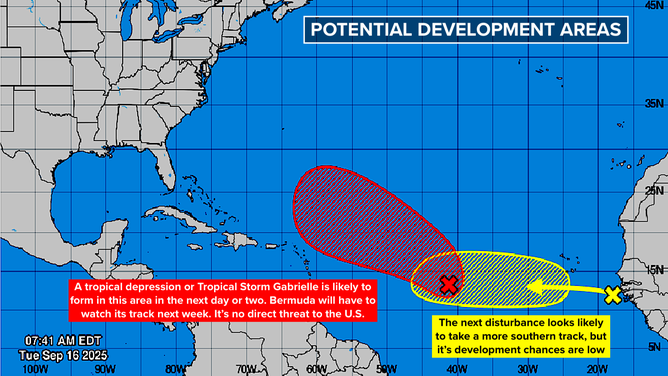
The computer forecast models mostly predict that likely-Gabrielle will quickly strengthen as it tracks well northeast of the Caribbean islands. Gabrielle could eventually turn into a significant hurricane.
Around the middle of next week, Gabrielle should be in the general vicinity of Bermuda. It’s too early to know if the threat to the island will materialize. The possible tracks that far out in time cut a wide swath.
After passing Bermuda, Gabrielle will speed into the North Atlantic and die.
Next in line
This graphic provides an overview of the tropical Atlantic Basin and development odds for Invest 92L and a new threat off the coast of Africa.
(FOX Weather)
Right on likely-Gabrielle’s heels, another tropical disturbance just moved off the African coast. This one will battle the same dry air, but also be contending with the air flowing out of its bigger sister developing nearby. The “outflow” air creates hostile upper winds over the system.
The consensus of the computer forecasts is that this disturbance will stay weak and not turn north. The National Hurricane Center gives it a low chance of developing into a depression in the next week. The current consensus of the computer models is that the disturbance will arrive at the Caribbean islands early next week as a moisture surge. But, of course, it bears watching.
Third in line
Some of the computer forecast models are picking up on another disturbance that is scheduled to move off Africa later this week. The early forecasts, such as we have them, show that system following Gabrielle into the central Atlantic. It appears that this one will have a better chance of developing.
Overall, the weather pattern does not look especially conducive to development, but a slice of the Atlantic is forecast to be supportive enough to allow one or two hurricanes to spin up in the open ocean.
The slow-moving, non-tropical coastal storm that has been battering the Carolinas and the mid-Atlantic is protecting the U.S. East Coast from any tropical systems arriving from the east. The steering flow associated with that storm will deflect all tropical traffic to the north.
Otherwise, there are no obvious threats out there.
150 years ago today
Unless you study Texas history or delve into hurricanes, you’ve probably never heard of Indianola, Texas. Indianola was a thriving town on the central Texas coast sitting on the edge of Matagorda Bay, between Corpus Christi and Houston/Galveston in the middle of the 19th century. It was the second-busiest port in Texas after Galveston, which was just over 100 miles up the coast.
But on this day in 1875, a Category 3 hurricane slammed the town with wind and storm surge. There was not much left when the storm passed.
The Indianola folk were resilient, however, and substantially rebuilt the town. Then 11 years later, a Category 4 storm wiped the town out for good.
Due to erosion and sea level rise, the land where much of the busy and prosperous town stood is now underwater.
Source link
editor's pick
latest video
Sports News To You
Subscribe to receive daily sports scores, hot takes, and breaking news!