Bryan Norcross: Erin likely to brush East Coast, cause dangerous conditions along beaches

Powerful Hurricane Erin is gaining strength after slamming parts of the Caribbean with strong winds and flooding rain, and impacts from the monster storm will be felt along the U.S. East Coast. FOX Weather Hurricane Specialist Bryan Norcross has expert analysis on the latest forecast and when impacts will be felt here.
Updated at 9:45 a.m. ET on Monday, Aug. 18, 2025
Hurricane Erin is intensifying again. Now back up to Category 4. And the storm is growing in size. Outer bands are lashing the Caribbean islands and will impact the southern end of the Bahamian chain today.
A Tropical Storm Warning is in effect for the Turks and Caicos and the southeastern Bahamas. A Tropical Storm Watch is in effect for the central Bahamas, meaning that sustained winds over 40 mph are possible if Erin wobbles a little bit to the left.
The official National Hurricane Center forecast still calls for Erin to intensify a bit more as it turns to the north later today. Meanwhile, the diameter of the area of strong winds will continue to grow, putting a tremendous amount of energy in the ocean water from the Caribbean to Canada.
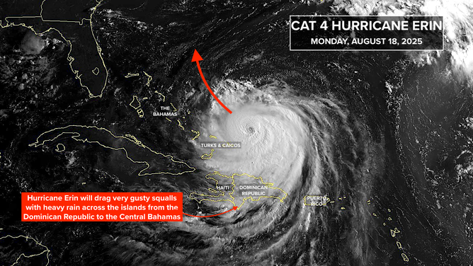
This satellite image shows Hurricane Erin on Aug. 18, 2025.
(NOAA)
There is high confidence that the core of the storm with the strongest winds will pass between North Carolina and Bermuda on Wednesday. The worst of the weather will be on the Bermuda side of the storm, but if Erin tracks closer to the left side of the cone as some computer forecasts indicate, outer bands will impact eastern North Carolina and perhaps some of the surrounding areas.
Tropical Storm Watches might be required for the Outer Banks later today. The National Hurricane Center will make that evaluation based on the latest computer forecasts. Remember that a watch means there is a possibility of sustained winds over 40 mph. This means gusts could reach 50 or 60 mph. The key word there is possibility.
Obviously, folks in Bermuda are watching Erin closely. If it veers to the right side of the cone, the weather there will be much worse.
The biggest impact from Erin’s passage paralleling the East Coast will be from the large, eroding waves and strong currents caused by the huge expanse of strong winds blowing over the ocean. The peak impacts along the beaches and in the waterways from Palm Beach County, Florida, to Cape Hatteras, North Carolina, look likely to occur tomorrow into Thursday, although the disturbed ocean will begin to be noticeable today.
On Thursday, as the hurricane moves north, the focus of the energy will move north to the coastline from Cape Hatteras to New England, including the Tidewater of Virginia, the Delmarva, the Jersey shore, Long Island, New York, and the New England coast.
These two images show the peak energy in white – where Erin is producing the highest waves offshore. The timing on the map showing the peak near North Carolina is around midnight Wednesday night/Thursday morning. The map with the peak farther north is at about 8 p.m. Thursday evening.
The swells – essentially the energy surges – generated by the hurricane will produce large, powerful waves capable of significant beach erosion, causing sand cliffs known as escarpments in some coastal sections. The most threatening times for the beaches and people will be at high tide. But at all times, it will be dangerous to be in the ocean with the water much above ankle level along most of the East Coast.
Plan to check with a harbormaster before doing any boating in the affected areas this week, and only swim near lifeguards.
Erin’s winds are forecast to peak today and then slowly diminish as the storm moves north and arcs out to sea. But don’t let the diminishing top winds fool you. The power in the circulation is simply spreading out, meaning it will put energy into a larger part of the ocean.
Next in line in the tropical Atlantic
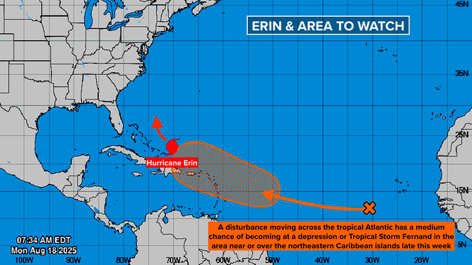
This graphic shows another tropical wave in the Atlantic Ocean on Aug. 18, 2025.
(NHC)
A disturbance is making its way across the tropical Atlantic toward the Caribbean. It’s forecast to arrive at the islands around Friday. The National Hurricane Center has the odds in the medium range that at least a depression will form in that large orange area that includes the northeastern Caribbean.
If the system develops into a tropical storm, it will be named Fernand.
The system’s path over next weekend and into next week is an open question. The computer forecasts have been flopping around, although the consensus is that the system will follow Erin to the north well offshore of the U.S. East Coast. We’ll see. Forecasts for undeveloped systems are always subject to change, of course.
Source link
editor's pick
latest video
Sports News To You
Subscribe to receive daily sports scores, hot takes, and breaking news!