Tropics shows signs of springing to life in Atlantic Basin as calendar flips to August
The FOX Forecast Center is monitoring the Main Development Region in the Atlantic Ocean, where some computer forecast models are showing signs of possible tropical activity as we head into August. FOX Weather Meteorologists Britta Merwin has the latest on July 31, 2025.
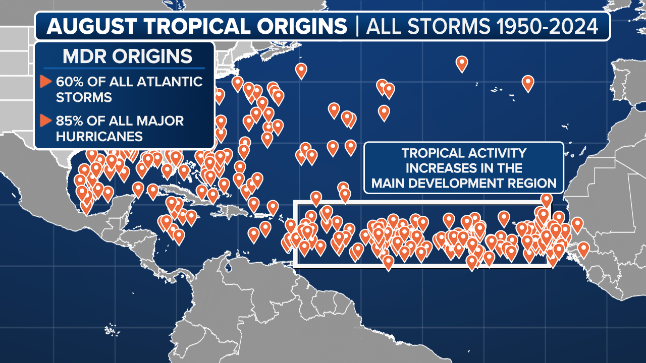
MIAMI – Some computer forecast models are showing signs that the Atlantic Basin’s Main Development Region between Africa and the Caribbean islands may be starting to see an uptick in tropical activity as we enter into August.
While nothing is immediately concerning or imminent when it comes to tropical development, it appears that the atmospheric conditions that have been hostile so far are showing inklings of gradually becoming more favorable.
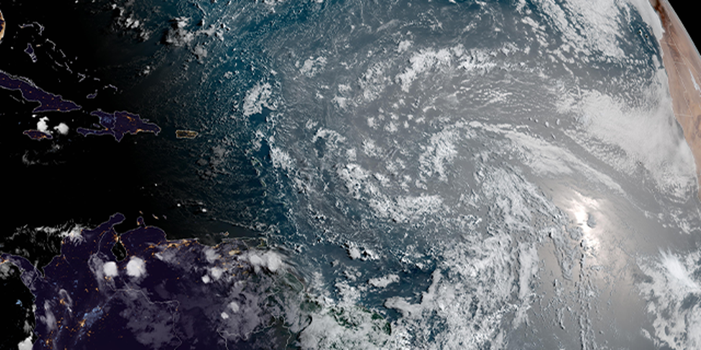
There is a tropical wave moving through the Main Development Region, but it isn’t a threat at this time.
(FOX Weather)
“We don’t even have a bona-fide system to track just yet,” FOX Weather Meteorologist Britta Merwin said. “But there’s enough indications in the long-term computer forecast models that say we should watch this tropical wave.”
First to note is that tropical waves coming off the western coast of Africa – among the typical inaugural ingredients for future tropical storms or hurricanes – are looking more robust. Already, two in particular that look impressive have started their journey into the eastern Atlantic and the heart of the Main Development Region.
However, the atmosphere hasn’t yet shed its tropical Kryptonite, and the clusters of thunderstorms will be fighting lingering layers of dry, Saharan dust and other pockets of dry air as they trek to the west. Those factors are forecast to weaken the systems as they merge and cross the Atlantic, but some forecast models indicate the storm may have enough moisture to survive reaching into the Caribbean, where it may find better atmospheric conditions to rejuvenate.
DOWNLOAD THE FREE FOX WEATHER APP
(FOX Weather)
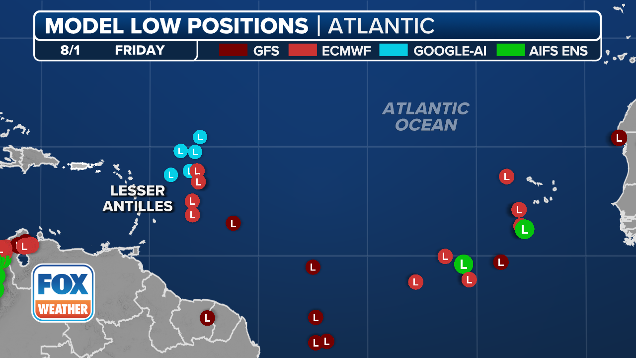
Some models indicate the system could emerge as a weak tropical disturbance near the northeastern Caribbean by the start of next week, according to the FOX Forecast Center, adding there is no indication it would be strong at that point.
What about after that? FOX Weather Hurricane Specialist Bryan Norcross says the long-range models looking into the end of next week give an indication that there could be a disturbance in that area east of the Bahamas.
“And then … the atmosphere gets much more conducive,” Norcross said. “Somewhere in this whole zone, from the Gulf all the way over to well east of the Bahamas and off the East Coast. So we’re just going to keep an eye as the atmosphere becomes just more ready for storms to develop somewhere in this tropical zone, not too far from the U.S.“
BRYAN NORCROSS: ATLANTIC REMAINS HOSTILE TO TROPICAL DEVELOPMENT – FOR NOW
Atlantic’s Main Development Region shows signs of life
(FOX Weather)
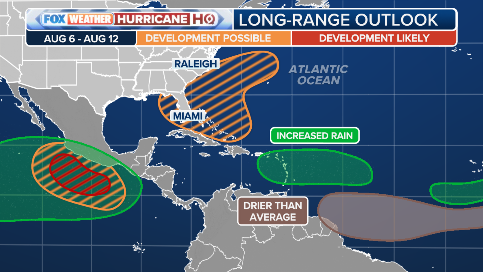
Behind that system, though, forecast models are already tracking the next robust waves eyeing the start of their transatlantic journey. Meanwhile, the longer-range forecasts are indicating a turn to more favorable tropical development conditions forming in the Atlantic, especially as we get into mid-August.
While the National Hurricane Center says it doesn’t expect any tropical activity over at least the next seven days, NOAA’s Climate Prediction Center’s three-week tropical outlook has now highlighted an area in the center of the Main Development Region as having low potential for tropical development.
(FOX Weather)
While dry, dusty air from the Sahara desert and hostile winds have effectively put a lid on tropical development in the Atlantic Ocean’s Main Development Region so far, the atmospheric conditions that have been so supportive of tropical development in the Pacific Ocean Basin are going to shift into the Gulf, Caribbean and Atlantic.
“We’re just going to keep an eye as the atmosphere becomes just more ready for storms to develop somewhere in this tropical zone, not too far from the U.S.,” Norcross said.
That timing lines up with what we can typically expect to see from the Madden-Julian Oscillation (MJO), which is a global weather pattern that can help to boost tropical activity when it moves over a region.
The MJO does look to become more favorable for the Atlantic in early August if it can hold together in the Eastern Pacific. If the MJO can persist into the Atlantic, the middle of the month is looking less hostile.
Source link
editor's pick
latest video
Sports News To You
Subscribe to receive daily sports scores, hot takes, and breaking news!