Severe weather to rock the Plains after Midwest gets blasted by tornadoes

Millions of people in the central U.S. are at risk of seeing severe weather on Tuesday, and the threat extends to the Chicago area on Wednesday. FOX Weather Storm Specialist Mike Seidel breaks down the forecast on June 17, 2025.
Millions of people in the central U.S. are bracing for another potentially dangerous day of severe weather on Tuesday, one day after tornadoes blasted across portions of Minnesota and Nebraska in the Midwest.
-

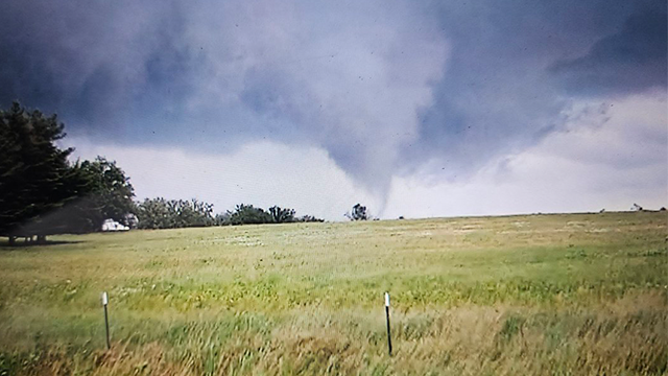
This image shows a massive tornado spinning near Dickens, Nebraska, on Monday, June 16, 2025.
(Lincoln County Sheriff’s Office/Facebook) -

This image shows a massive tornado spinning near Dickens, Nebraska, on Monday, June 16, 2025.
(Lincoln County Sheriff’s Office/Facebook) -

This image shows a massive tornado spinning near Dickens, Nebraska, on Monday, June 16, 2025.
(Lincoln County Sheriff’s Office/Facebook) -
This image shows a tornado in Lake Shore, Minnesota, on Monday, June 16, 2025.
(Corey Gerken) -
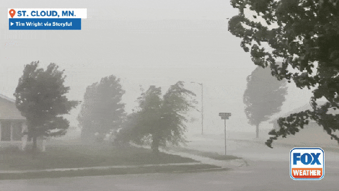
Strong winds and heavy rain near St. Cloud, Minnesota on Monday, June 16, 2025.
(Tim Wright via Storyful)
The action kicked off early Tuesday morning when severe thunderstorms plowed across Kansas, where a record 101-mph wind gust was reported in Wichita.
A Severe Thunderstorm Watch, as well as numerous Flood Watches and Flash Flood Warnings, were also issued early on Tuesday morning.

(FOX Weather)
More severe weather is expected throughout the day on Tuesday across portions of the central Plains and into the Missouri Valley, which is farther south than where the storms were on Monday.
The FOX Forecast Center said a cold front will continue to plow across the region, and warm, humid air out ahead of it will help to fuel the development of thunderstorms.
Early on, a few isolated storms could grow strong enough to produce giant hail. As the day progresses, storms may group together into a line, increasing the threat for extreme wind gusts.
DOWNLOAD THE FREE FOX WEATHER APP

(FOX Weather)
NOAA’s Storm Prediction Center (SPC) placed portions of western and central Kansas in a Level 4 threat on its 5-point severe thunderstorm risk scale.
This includes cities such as Wichita, Hutchinson, Garden City, Dodge City and Derby in Kansas.
More than 2 million people were placed in a Level 3 out of 5 threat from portions of Colorado through west-central Missouri, including cities like Topeka and Lawrence in Kansas.
A Level 2 out of 5 threat exists from Colorado and Wyoming through the central Plains into Iowa and Missouri.
This threat zone includes cities like Denver, Kansas City and Tulsa in Oklahoma.
Giant hail, destructive wind gusts and even tornadoes will be possible on Tuesday.
Source link
editor's pick
latest video
Sports News To You
Subscribe to receive daily sports scores, hot takes, and breaking news!