
South Florida severe weather signals wet season is near

Video from Seven Mile Bridge shows a large waterspout spinning over the ocean in the Florida Keys.
PEMBROKE PINES, Fla. – Severe thunderstorms swept across South Florida on Friday, bringing damaging winds, hail and localized flooding in what could be a signal that the state’s rainy season is quickly approaching.
The storms, which developed with the enhancement of an old frontal boundary, caused notable damage in several areas.
At the North Perry Airport in Pembroke Pines, at least one plane was tossed by the gusty winds and trees and power lines were reported down in Broward County.
On the Treasure Coast, hail the size of limes fell, which has only happened a few dozen times since the 1950s.
Despite some residents believing a tornado had touched down, the National Weather Service said the damage was representative of gusty winds from a downburst.
Downbursts are rapid columns of descending air that spread outward upon hitting the ground and can generate wind speeds that top 100 mph.
Depending on their size and duration, these phenomena can be classified as either microbursts or macrobursts.
While microbursts are smaller and more intense, macrobursts affect larger areas with slightly less concentrated winds.
Further south in the Florida Keys, thunderstorm activity produced waterspouts and funnel clouds, but no damage was reported.
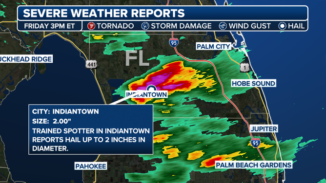
Large hail reported in Martin County, Florida on 5/23/2025.
(FOX Weather)
NEW TO FLORIDA? HERE’S WHEN THE SUNSHINE STATE’S RAINY SEASON GETS UNDERWAY
The timing of the storms aligns with the onset of Florida’s rainy season, which typically begins in mid to late May and lasts into September.
The seasonal activity is primarily driven by high temperatures, bountiful moisture and converging sea breezes, which often is sufficient enough to trigger strong to severe storms.
The duration and intensity of the rainy season can be influenced by global climate patterns such as El Niño and La Niña.
During El Niño years, Florida’s wet season may be delayed and less intense, while La Niña tends to accelerate the onset of daily thunderstorms and leads to increased rainfall.
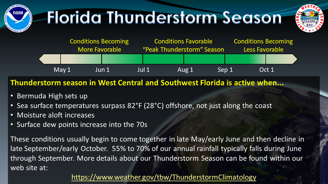
The normal wet weather pattern typically starts in late May and runs into September.
(NOAA)
Current observations place the El Niño–Southern Oscillation, or what is known as the ENSO, in a neutral phase, with hints of La Niña stage.
As a result, average to above-average rainfall is expected throughout much of the summer across Florida.
The forecast comes as welcome news for drought-stricken regions across the state, particularly areas south of the Interstate 4 corridor.
Although drought conditions still remain, consistent rainfall over the coming weeks may begin to alleviate the large deficits.
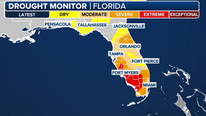
Florida drought map as of 5/23/2025.
(FOX Weather)
WHERE YOU CAN DITCH THE RAIN AT UNIVERSAL’S EPIC UNIVERSE THEME PARK
Historically, the first half of the rainy season tends to produce more intense thunderstorms, including frequent lightning, damaging winds and occasional large hail.
The latter half often produces the highest rainfall totals, with fewer reports of damage.
Florida’s rainy season typically winds down by late September, at which point the focus shifts toward tropical systems and, eventually, cold fronts moving in from the north and west.
Source link
editor's pick
latest video
Sports News To You
Subscribe to receive daily sports scores, hot takes, and breaking news!