Western North Carolina faces ‘first noteworthy flood threat’ since Helene

Areas of Helene-ravaged North Carolina are on alert for flash flooding as a potent storm system slams the Southeast and mid-Atlantic with heavy rain and thunderstorms as we kick off the new workweek. FOX Weather Meteorologist Britta Merwin has the latest on Monday, May 12, 2025.
ASHEVILLE, N.C. – Areas of western North Carolina still in recovery mode due to the deadly destruction caused by Hurricane Helene last year are again on alert for flash flooding as a potent storm system brings rounds of torrential rain and thunderstorms to communities across the Southeast and mid-Atlantic.

A video recorded in Pensacola Beach, Florida, shows a waterspout moving onshore on Saturday, May 10, 2025.
The FOX Forecast Center said this is the same system that brought flooding rain and severe weather, including reports of tornadoes and waterspouts, to cities along the Gulf Coast over the weekend.
And while the rain was a nuisance in Florida over Mother’s Day weekend, it was beneficial as the Sunshine State deals with its worst drought since 2012.

(FOX Weather)
The FOX Forecast Center said that after lingering over the Southeast over the weekend, a stubborn area of low pressure will finally begin to lift into the Tennessee Valley starting on Monday.
As it does so, a new round of widespread rain and thunderstorms is expected to develop across the Southeast and southern mid-Atlantic, especially within the warm, moisture-rich air mass surging ahead of a cold front.
That setup will help to focus moisture along two key areas – one along the Southeast coast, and another across the upslope terrain of the southern Appalachians.
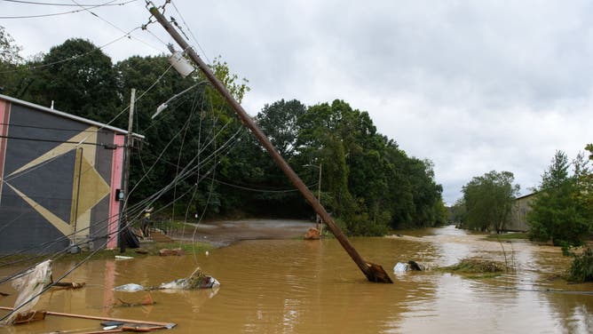
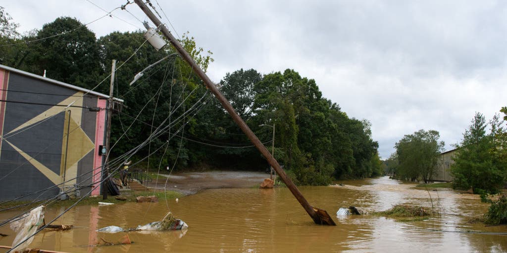
FILE – Heavy rains from Hurricane Helene caused record flooding and damage on September 28, 2024 in Asheville, North Carolina. Hurricane Helene made landfall in Florida’s Big Bend on Thursday night with winds up to 140 mph and storm surges that killed at least 42 people in several states. (Photo by Melissa Sue Gerrits/Getty Images)
(Getty Images)
Those areas, especially the higher elevations from northern Georgia through western North Carolina and into Virginia, are more sensitive to enhanced rain due to lower flash flood thresholds and the lingering vulnerability from Hurricane Helene.
“It is eight months since Hurricane Helene just devastated parts of our country,” FOX Weather Meteorologist Britta Merwin said. “You think about western North Carolina, eastern Tennessee, just changed forever. And they are still recovering. But with today’s flash flood threat, the recovery process could become more complicated.”
DOWNLOAD THE FREE FOX WEATHER APP

It’s been less than a year since Hurricane Helene devastated parts of western North Carolina, and a potent storm system moving into the area on Monday is bringing the first noteworthy flood threat since the disaster. FOX Weather Meteorologist Britta Merwin breaks down the latest on Monday, May 12, 2025.
Flash flooding is a concern up and down the East Coast on Monday, but NOAA‘s Weather Prediction Center placed portions of South Florida, including Miami, in a Level 3 out of 4 flash flood threat.
To the north, through Georgia, the Carolinas and Virginia, a Level 2 out of 4 threat exists.

(FOX Weather)
“The potential for flash flooding, even landslides, being mentioned by the National Weather Service office, there’s a lot of concern for these communities,” Merwin continued.
Even the NWS office in Greenville, South Carolina, has warned residents about the flood potential.
“While the flooding from this event is not expected to be on the higher end, it’s the first noteworthy flood threat that our area has seen since Helene,” the NWS said.
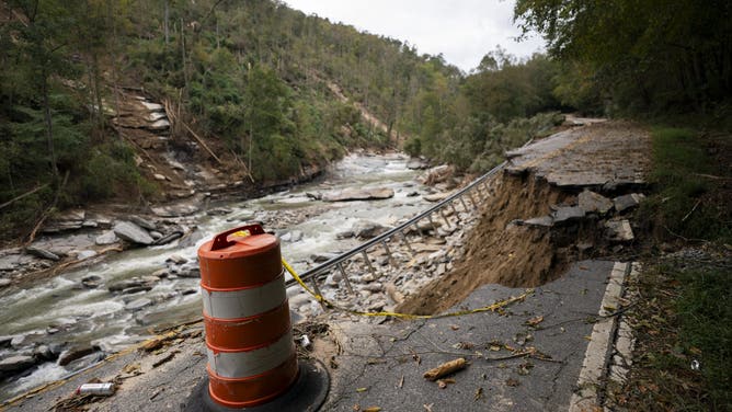
FILE – North Carolina Route 9 in the aftermath of Hurricane Helene on October 1, 2024 in Bat Cave, North Carolina. The death toll has topped 140 people across the southeastern U.S. due to the storm, according to published reports, which made landfall as a category 4 storm on Thursday. Millions are without power and the federal government has declared major disasters in areas of North Carolina, Florida, South Carolina, Tennessee, Georgia, Virginia and Alabama, freeing up federal emergency management money and resources for those states, according to the reports. (Photo by Sean Rayford/Getty Images)
It’s important to note that the flood threat in western North Carolina isn’t anywhere near the threat that was seen when Helene plowed across the region, but there is still a danger.
“Using the words from the National Weather Service office, since they went through the disaster,” Merwin said. “That not only remarks a psychology aspect of this, but also a safety aspect. The fact that we could see landslides, a very important thing to communicate as we’re trying to rebuild and move forward.”

(FOX Weather)
There’s also a severe weather threat across the region.
NOAA’s Storm Prediction Center placed millions of people in cities like Miami, Tampa and Jacksonville in Florida, as well as Atlanta, in a Level 1 threat on its 5-point severe thunderstorm risk scale.
Thunderstorms that develop will be capable of producing damaging wind gusts, large hail and even some tornadoes.

(FOX Weather)
The FOX Forecast Center said the system is expected to move out of the Southeast by Tuesday, gradually diminishing the flash flood threat. However, rainfall totals throughout the duration of the event are expected to range from 3 to 5 inches across much of the Southeast.
Some parts of the Appalachian Mountains in the western Carolinas could see 5 inches or more of rain.
Source link
editor's pick
latest video
Sports News To You
Subscribe to receive daily sports scores, hot takes, and breaking news!