
Severe weather threatens 87M Friday. Texas, Oklahoma slammed with flooding.
Severe storms are ongoing across Oklahoma and Northern Texas once again Friday morning. Storms will move east during the day and could reach the Tennessee Valley and Southern Appalachians bringing heavy rain in a short period of time.
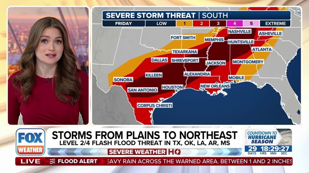
Severe storms pummeled Oklahoma and Northern Texas for the 10th consecutive day Friday morning, kicking off another day of dangerous weather threats covering nearly 87 million people as a potent cold front stretches from San Antonio to Albany, New York.
The most widespread risk is once again in the southern Plains, where atmospheric conditions have the potential to develop into a squall line of dangerous severe thunderstorms that will move east during the day Friday. Storms will eventually reach the Tennessee Valley and Southern Appalachians late in the day with areas of damaging wind gusts over 60 mph, tennis-ball-sized hail and even scattered tornadoes.
A Level 3 out of 5 risk for severe storms has been issued by NOAA’s Storm Prediction Center stretching from San Antonio, Texas to Nashville, Tennessee and into central Kentucky.
SHOWERS COULD CREATE WET TRACK FOR 151ST KENTUCKY DERBY

FOX Weather
Dangerous hail threat covers San Antonio, Austin metro areas
Severe storms will also likely reorganize over central Texas on Friday evening, accompanied by the risk of large hail covering San Antonio and Austin. Hailstones could reach golf ball to tennis ball in size, especially in the darker-shaded purple areas below.
HOW TO PROTECT YOUR VEHICLE FROM A HAILSTORM

(FOX Weather)
Severe storms break Dallas rain record Thursday; tornado injures 1 person
It’s no rest for the storm-weary in Texas and Oklahoma where severe weather has felt relentless.
Emergency officials in Burnet County, Texas, which is 50 miles northwest of Austin, said a tornado touched down Thursday afternoon and injured a driver and destroyed several homes.
Dallas registered 2.4 inches of rain on Thursday, breaking a daily record set back in 1905. The rounds of severe weather made this past month the city’s fifth-wettest April in the last 55 years.
Flash Flood Warnings were ongoing Friday morning in southern Oklahoma. That comes after Thursday morning’s flooding washed out road leading to the town of Blanchard in Grady County, Oklahoma, leaving people in that community stranded.
MAY IS PEAK MONTH FOR TORNADOES IN THE US
-

Tornado-warned storm looms over Briggs, Texas. Thursday afternoon, May 1, 2025.
(Mark Overbeck/ @Mrk_WX on X) -

Tornado-warned storm looms over Briggs, Texas. Thursday afternoon, May 1, 2025.
( Mark Overbeck/ @Mrk_WX on X) -

Flooding from severe storms washes out the road leading to Blanchard, OK, effectively cutting the town off from ground travel.
(KOKH) -

Flooding from severe storms washes out the road leading to Blanchard, OK, effectively cutting the town off from ground travel.
(KOKH)
Another 1-2 inches of rain could fall in stubborn thunderstorms on Friday. NOAA’s Weather Prediction Center has issued a Level 2 out of 4 threat of flash flooding lasting through Saturday morning for a wide swath of Texas, Oklahoma, western Arkansas, and Louisiana, as storms finally begin to track east after being parked over the Red River Valley.
WATCH: CARS DRIVE THROUGH FLOODED STREET IN CENTRAL OKLAHOMA

(FOX Weather)
Thunderstorms target Ohio Valley, Northeast Friday
On the northern side of the cold front, thunderstorms will fire across parts of the Ohio Valley and Northeast. These storms will be more scattered in nature throughout the day but could bring damaging wind and large hail.

(FOX Weather)
That includes the Pittsburgh area and the rest of the Ohio Valley again, which could use a break in the weather instead. Over 130,000 customers still remain without power in western Pennsylvania, according to FindEnergy.com, after Tuesday’s deadly derecho claimed at least three lives.
A Level 3 out of 5 severe weather threat reaches into Kentucky, while a level 2 risk includes Cincinnati, Columbus and Charleston, West Virginia.
A reduced severe threat extends north covering most of Pennsylvania, central New York, southern Vermont and western Massachusetts, but those areas could still see isolated thunderstorms that bring damaging wind gusts and large hail.
The active weather lingers through Saturday with a marginal threat of severe weather blanketing most of the Eastern Seaboard.
SEVERE THUNDERSTORMS ROLL THROUGH AREAS THURSDAY STILL RECOVERING FROM ROUNDS OF DAMAGING STORMS
Source link
editor's pick
latest video
Sports News To You
Subscribe to receive daily sports scores, hot takes, and breaking news!