Heartland braces for possible EF-2+ tornadoes just days after deadly outbreak
Severe storms target the Heartland today, bringing renewed threats of more damaging wind, large hail and even more tornadoes, with some areas already in the EF2+ risk range. This includes parts of the region still recovering from a tornado outbreak less than a week ago. Stay prepared and keep up with the latest updates all day with FOX Weather.
The severe weather in the Central U.S. is not letting up. The Heartland is bracing for another deadly round of storms, with possible EF-2+ tornadoes looming on Tuesday, just days after last week’s deadly outbreak.
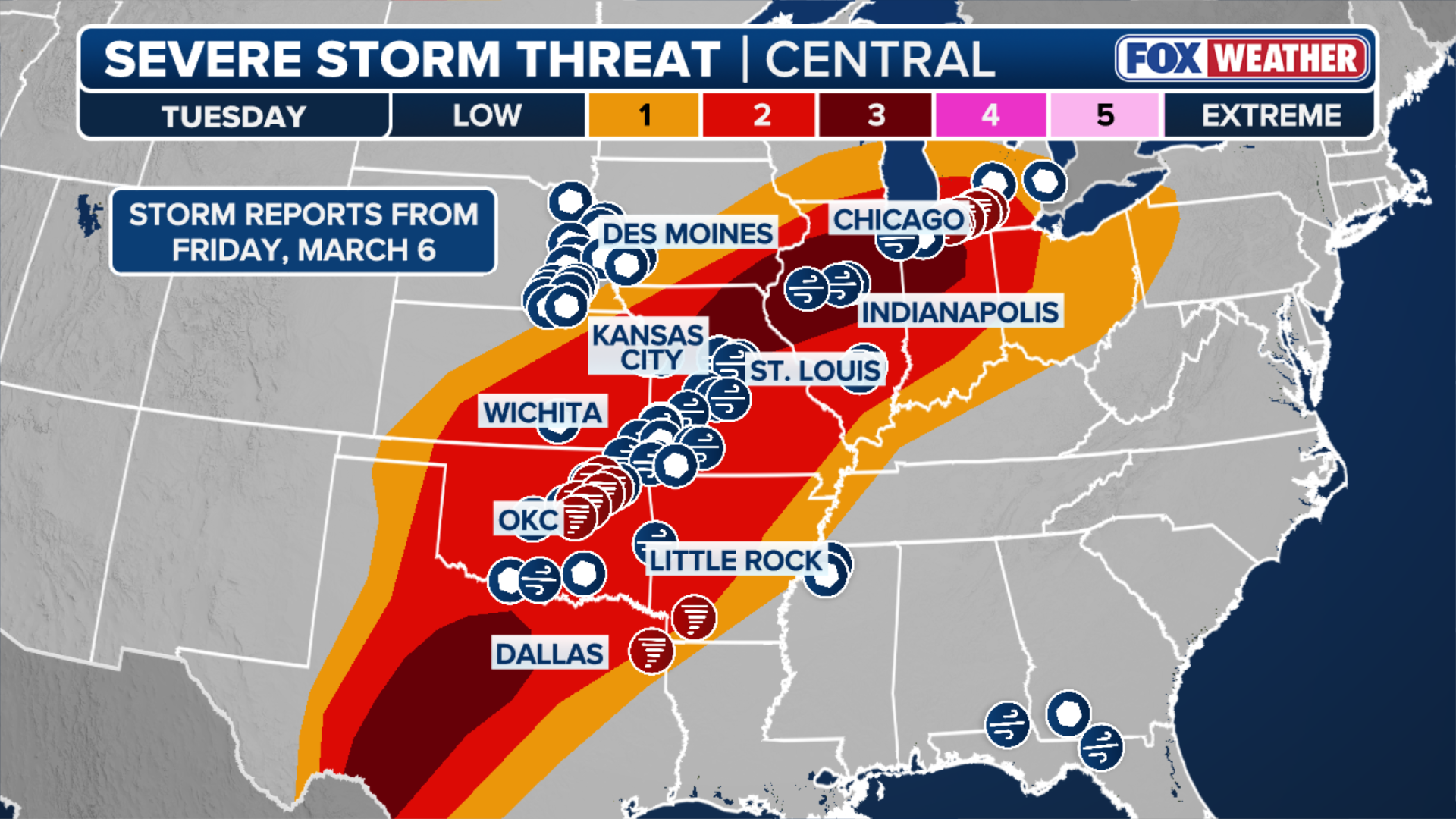
More than 10 states are in the risk zone, placing millions of people in the potential path of damaging winds, large hail and strong tornadoes, some of which could reach EF-2 intensity or stronger.
(FOX Weather)
The renewed severe weather threat—spanning 1,500 miles from Texas to Michigan—comes as many communities are still recovering from the devastating tornado outbreak late last week, raising concerns about additional impacts if storms redevelop across the region.
At least 23 tornadoes ripped through the Heartland between Thursday, March 5, and Saturday, March 7, ranging in strength from EF-0 to EF-3, claiming the lives of eight people and leaving communities devastated in their wake.
-

Damage caused by a tornado in Union City, Michigan.
(FOX Weather) -

Storm damage in Kinmundy, IL, March 7
(Salem/Marion COunty EMA) -

Storm damage in Kinmundy, IL, March 7
(Salem/Marion COunty EMA) -

Storm damage in Kinmundy, IL, March 7
(Salem/Marion COunty EMA) -

Storm damage in Kinmundy, IL, March 7
(Salem/Marion COunty EMA) -

Storm damage in Kinmundy, IL, March 7
(Salem/Marion COunty EMA) -

Storm damage in Kinmundy, IL, March 7
(Salem/Marion COunty EMA) -

A photo is scattered on a Union City, MI, lawn on March 7 after deadly tornado outbreak
(Celena Sanchez / FOX Weather) -

bt-override union city drone
( ) -

Widespread tornado damage in Union City, MI, March 7.
(Haley Meier) -

Widespread tornado damage in Union City, MI, March 7.
(Celena Sanchez / FOX Weather) -

Widespread tornado damage in Union City, MI, March 7.
(Celena Sanchez / FOX Weather) -

Widespread tornado damage in Union City, MI, March 7.
(Celena Sanchez / FOX Weather) -

Widespread tornado damage in Union City, MI, March 7.
(Celena Sanchez / FOX Weather) -

Widespread tornado damage in Union City, MI, March 7.
(Celena Sanchez / FOX Weather) -

Widespread tornado damage in Union City, MI, March 7.
(Celena Sanchez / FOX Weather) -

Widespread tornado damage in Union City, MI, March 7.
(Celena Sanchez / FOX Weather) -

Tornado damages church in Union City, MI, Friday March 6
(KRISTEN RIEDER) -

Tornado damages church in Union City, MI, Friday March 6
(KRISTEN RIEDER) -

Tornado damages church in Union City, MI, Friday March 6
(KRISTEN RIEDER) -

Tornado damages church in Union City, MI, Friday March 6
(KRISTEN RIEDER) -

Tornado damages church in Union City, MI, Friday March 6
(KRISTEN RIEDER) -

bt override for union city, michigan tornado damage
( )
The multi-day severe weather outbreak ripped through Texas, the Plains, and the Midwest before it charged towards the Great Lakes and the Northeast.
Portions of those same areas are yet again in the zone for another round of intense severe storms that will continue into the evening, with a Level 3 out of 5 threat centered over Illinois and Texas.
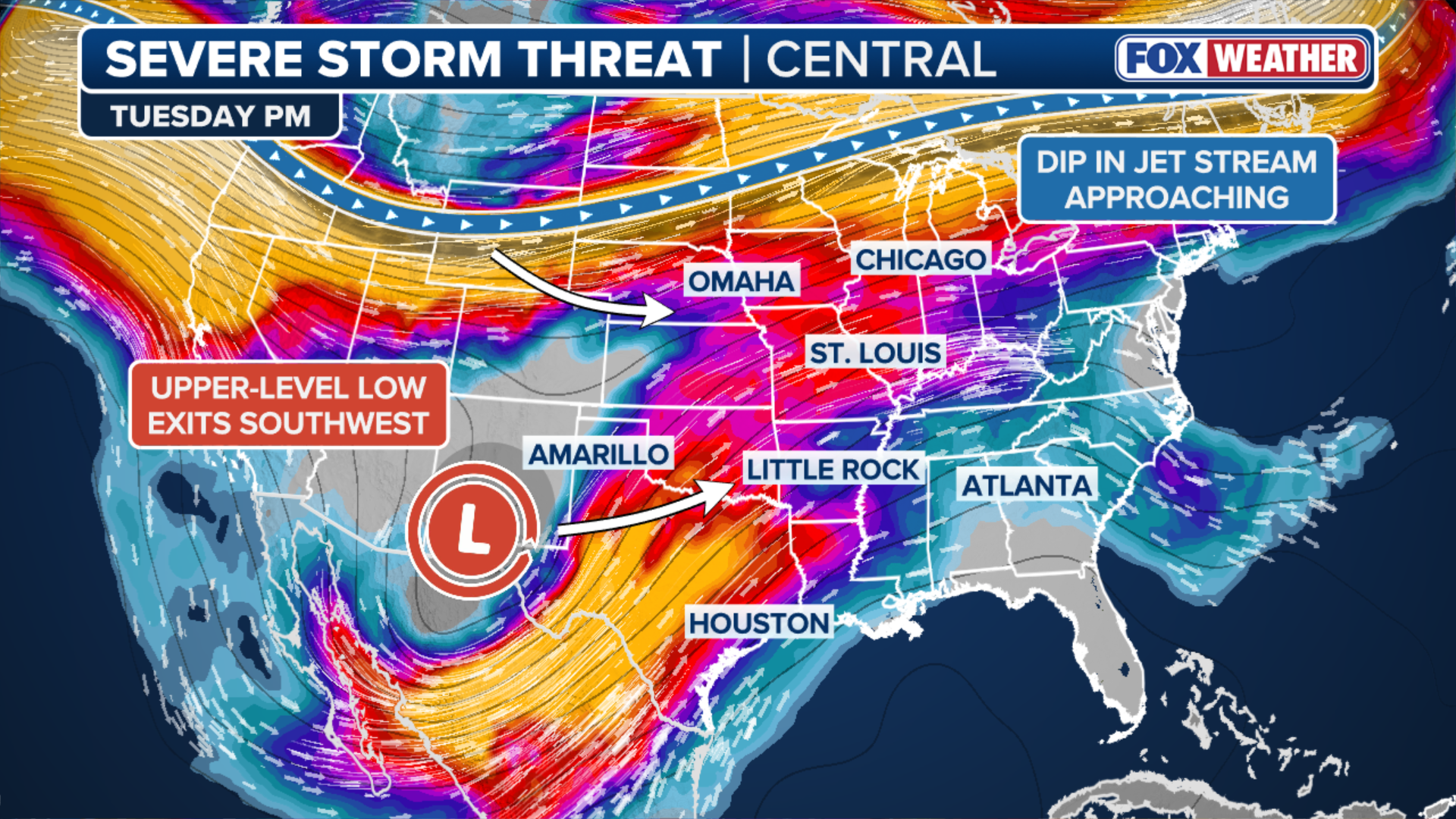
An upper-level disturbance over northwest Mexico is forecast to move northeast into the Southern Rockies and eventually into the High Plains.
MOTHER, DAUGHTER TRAGICALLY KILLED DURING SEVERE WEATHER IN OKLAHOMA AMID MULTI-DAY OUTBREAK
Simultaneously, a separate system moving across the northern U.S. will intensify over the central part of the country, and when these two systems start to interact, winds higher in the atmosphere will pick up from the southwest.
As this setup will help pull warm, humid air north from the Gulf of America, dew points in the 60s are expected to spread across much of Texas, Oklahoma, and eastern Kansas, and eventually extend into the Mid-Mississippi and Ohio Valleys.
(FOX Weather)
In turn, this will create a broad warm sector across the region — an area of warm, unstable air — that can support strong thunderstorms.
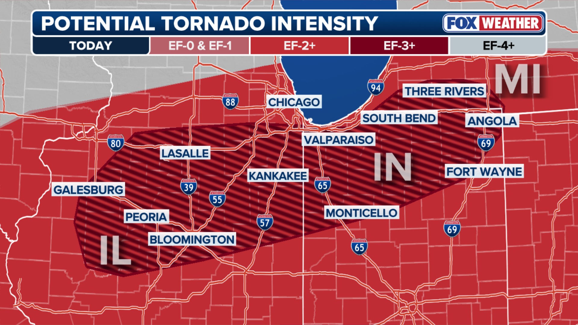
Within this large zone, there is a narrow corridor being monitored in Illinois, Missouri and central Texas, where a Level 3 out of 5 threat is in place.
RELATIVE DETAILS THE MOMENTS MOTHER AND DAUGHTER WERE TRAGICALLY KILLED IN OKLAHOMA TORNADO
A broader Level 2 out of 5 threat expands from Lake Michigan down to the Texas-Mexico border.
The FOX Forecast Center said, at the surface, two low-pressure systems are expected to take shape.
One may develop near the Texas and Oklahoma Panhandles, while another forms farther north from northwest Missouri into Iowa.

(FOX Weather)
A dryline extending south from the Plains low will separate very dry air to the west from warm, humid air to the east. Meanwhile, a warm front is forecast to extend from southern Iowa into northern Illinois and Indiana by the afternoon.
While there is still some uncertainty about the exact placement of these boundaries, with the overall environment featuring strong winds at multiple levels of the atmosphere — helping promote rotating storms — along with plenty of moisture and moderate instability, it’s favorable for widespread severe thunderstorms.
DEADLY TORNADO DEVASTATES UNION CITY, MICHIGAN, CARVING A PATH OF HEARTBREAKING DAMAGE IN COMMUNITY
With the storms that form Tuesday afternoon potentially becoming supercells, large to very large hail is possible.
As the evening progresses, the risk for tornadoes will likely increase close to the warm front and where the dryline, warm front, and cold front intersect.
(FOX Weather)
It is the areas from parts of Missouri into Illinois within the Level 3 out of 5 threat that will see the highest tornado threat, with multiple zones potentially reaching an EF2+.
The severe weather threat is expected to continue well into Tuesday night as a strong low-level jet develops.
This will continue feeding warm, moist air into the storms even after sunset, likely triggering thunderstorms to remain active and severe across parts of the region overnight.

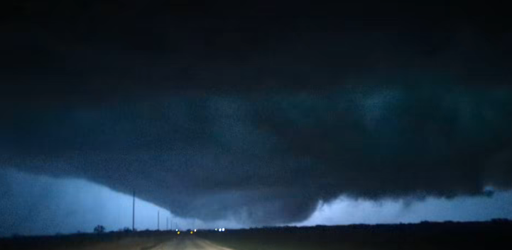
Devastating tornado caught on camera in Union City, Michigan
(Lisa Nicola / FOX Weather)
DEADLY TORNADO DEVASTATES UNION CITY, MICHIGAN, CARVING A PATH OF HEARTBREAKING DAMAGE IN COMMUNITY
The FOX Forecast Center highlights these cities for the top severe weather threats: Springfield, Peoria, Bloomington and Quincy, Chicago, Illinois; Dallas and San Angelo, Texas; Indianapolis, Indiana and Oklahoma City, Oklahoma.
Source link
editor's pick
latest video
Sports News To You
Subscribe to receive daily sports scores, hot takes, and breaking news!