
Major snowstorm possible for Northeast I-95 corridor this weekend

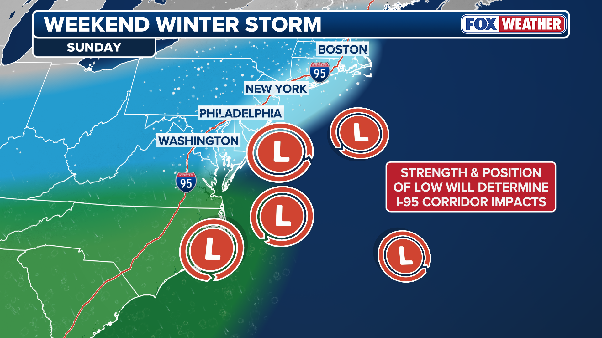
The FOX Forecast Center is tracking the potential for a significant snowstorm and potential Nor’easter to impact the I-95 corridor Sunday into Monday. The third in a series of three winter storms set to impact the Eastern U.S. this week, the Sunday-Monday system has the highest ceiling for significant impacts. The storm originates from a disturbance currently moving along the coast of British Columbia in Canada. As it reaches the East Coast, it is expected to develop a surface low-pressure system that will track offshore, potentially bringing major snow to the Northeast. However, the forecast is far from set in stone. Everything needs to line up perfectly for a “blockbuster” storm.
NEW YORK – The FOX Forecast Center is monitoring the potential threat of a significant snowstorm and potential nor’easter that could impact millions across the Interstate 95 corridor Sunday night into Monday.
Some snow is possible over the weekend across the Philadelphia, New York City and Boston metro areas — exactly when and how much remains an open question.
-

HOBOKEN, NJ – JANUARY 26: A person jogs along a snow-covered walkway in front of the skyline of lower Manhattan and One World Trade Center in New York City on January 26, 2026, in Hoboken, New Jersey.
( (Photo by Gary Hershorn/Getty Images)) -

People walk in the snow in Central Park in New York City on December 27, 2025. New York City received around 4 inches (10 centimeters) of snow overnight. Airlines canceled 1,500 US flights during the peak holiday travel period Friday, with severe winter storm warnings and heavy snow forecast across parts of the Midwest and northeast. (Photo by TIMOTHY A. CLARY / AFP via Getty Images)
(Photo by TIMOTHY A. CLARY / AFP via Getty Images) -

FILE – PHILADELPHIA, PA – JANUARY 27: A general view of the exterior of Citizens Bank Park with snow during stadium shoot at Citizens Bank Park on Tuesday, January 27, 2026 in Philadelphia, Pennsylvania.
((Photo by Denis Kennedy/MLB Photos via Getty Images)) -

Workers clear snow in Copley Square during a snowstorm in Boston, Massachusetts, on January 25, 2026.
((Photo by Joseph Prezioso / AFP via Getty Images)) -

A person walks through Boston Public Garden during heavy snow on January 25, 2026 in Boston, Massachusetts.
(Scott Eisen/Getty Images)
A series of storms is moving out of the West this week after delivering flooding rain and much-needed snow to that region. These systems will bring rounds of nuisance rain into the Northeast as they track into the region through the end of the workweek.
Forecasters are primarily concerned about the third storm which is moving along the coast of British Columbia in Canada and will eject into the Lower 48 beginning Thursday night into Friday.

(FOX Weather)
According to the FOX Forecast Center, as it reaches the East Coast, it is expected to develop into a surface low-pressure system that will track offshore, potentially becoming a powerful coastal storm that will drop significant snow across the Northeast.
HOW HIGH PRESSURE AND LOW PRESSURE DRIVE THE WEATHER
However, the forecast is far from settled, as many across the region are bracing for the latest blow in what has been the most active winter season in recent years.
Many cities across the Northeast still have snow on the ground from January’s historic winter storm.
(FOX Weather)
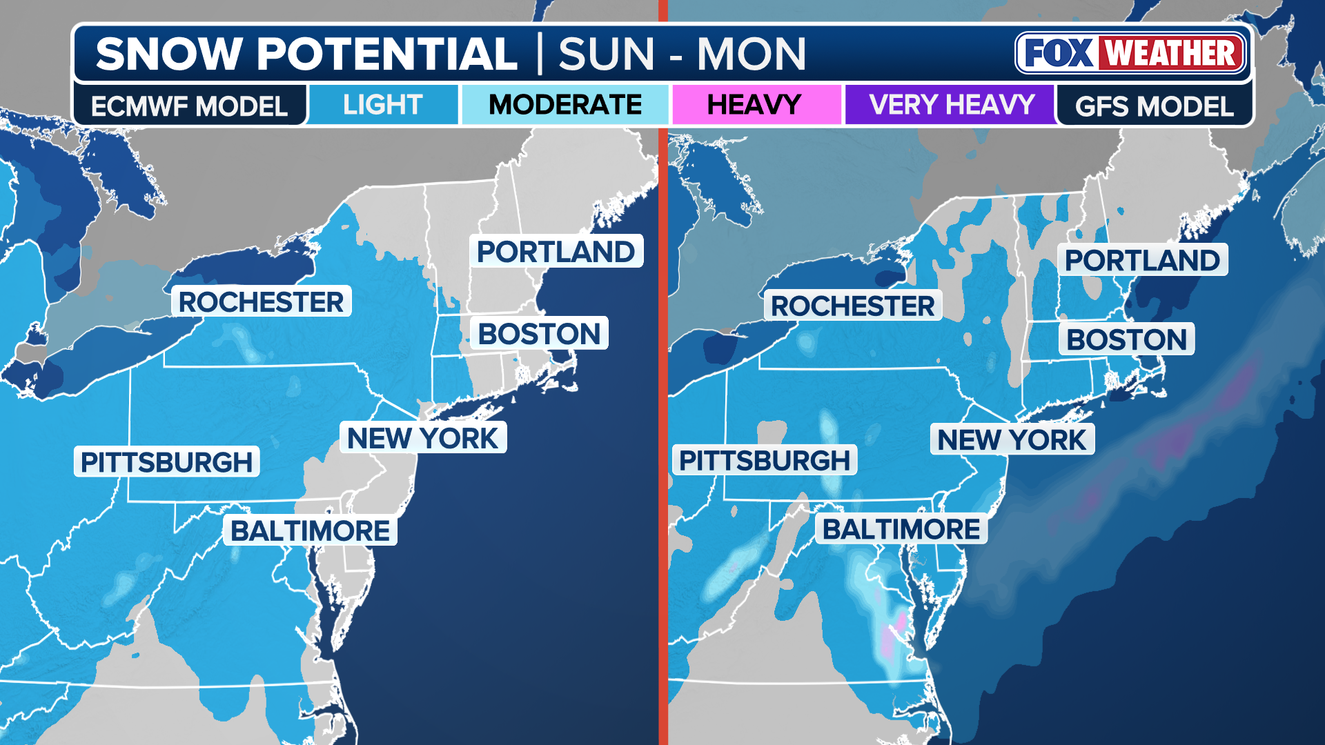
Currently, both the American GFS and European forecast models indicate light snow for different parts of the Ohio Valley, Mid-Atlantic and I-95 corridor from Sunday night into Monday.
Meanwhile, several AI forecast models seem to signal a more powerful snow event over the same timeframe.
ICONIC APOSTLE ISLANDS ICE CAVES AT LAKE SUPERIOR REOPEN FOR THE FIRST TIME SINCE 2015
The biggest uncertainties are how quickly the storm strengthens as it heads into the Great Lakes and exactly where it emerges off the East Coast.
(FOX Weather)
A number of factors would need to line up to produce blockbuster impacts, namely a slow and precise track along the northeast coast and enough cold air from Canada.
Snow totals will be limited if any one of these forecast ingredients are missing.
“While some snow appears to be the most likely outcome, all scenarios remain on the table, from a complete miss that tracks out to sea, to a major Nor’easter,” the FOX Forecast Center said Wednesday.
The forecast will come into better focus as the weekend approaches.
Check back for updates as this forecast develops.
Source link
editor's pick
latest video
Sports News To You
Subscribe to receive daily sports scores, hot takes, and breaking news!