Major winter storm: How much snow will Americans see?

Winter Storm Watches have expanded across the country ahead of this weekend’s massive and potentially historic winter storm. The scope of this system will be immense, with snow and ice stretching from the Southwest through Texas and Oklahoma, across the South and Tennessee Valley, before eventually reaching the Mid-Atlantic coast. More than 175 million people are in the path of this sprawling system which is expected to move out of the Southwest by Friday. A key remaining question is exactly how far north this storm will track. A shift in track will determine which states will see heavy snow versus crippling ice.
A potentially historic winter storm is taking shape later this week, bringing heavy snow and debilitating ice across more than 30 states. Winter Storm Watches have expanded as the snow and ice footprint is expected to stretch over 2,000 miles, from the Southern Plains to the Mid-Atlantic.
Friday impacts are expected to start and lead into Monday of next week.
So how much snow are Americans expected to see with this major winter storm system?
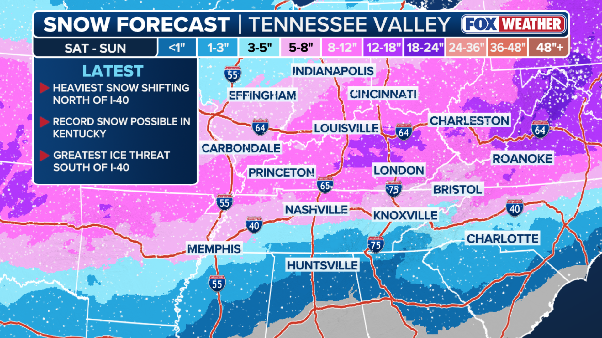
Much of the Southern Plains, Southeast and Mid-Atlantic have high confidence in a swath of fresh powder. However, the FOX Forecast Center said key questions remain on how far north the storm will track and whether it will bring snow to the Northeast.
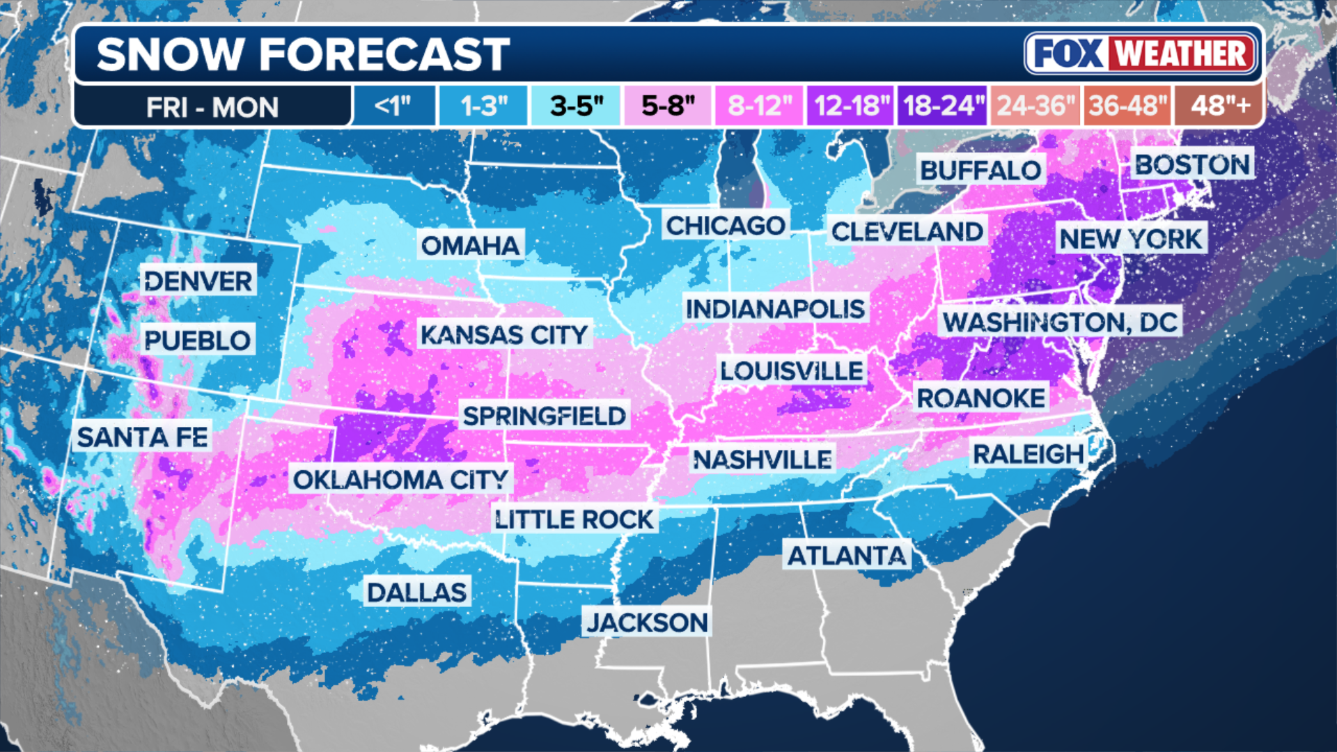
(FOX Weather)
Southwest and Southern Rockies
Across much of New Mexico, Arizona, Colorado and Utah, snowfall is expected to range from 1–12 inches, with some mountainous areas potentially reaching up to 2 feet of snow.
Santa Fe is looking at up to 8 inches of snow locally, while higher elevations near Flagstaff and Telluride could see a foot or more.
Other cities in the region, including Page, Alamosa, Farmington and Cedar City, are likely to receive between 3–8 inches of snow.
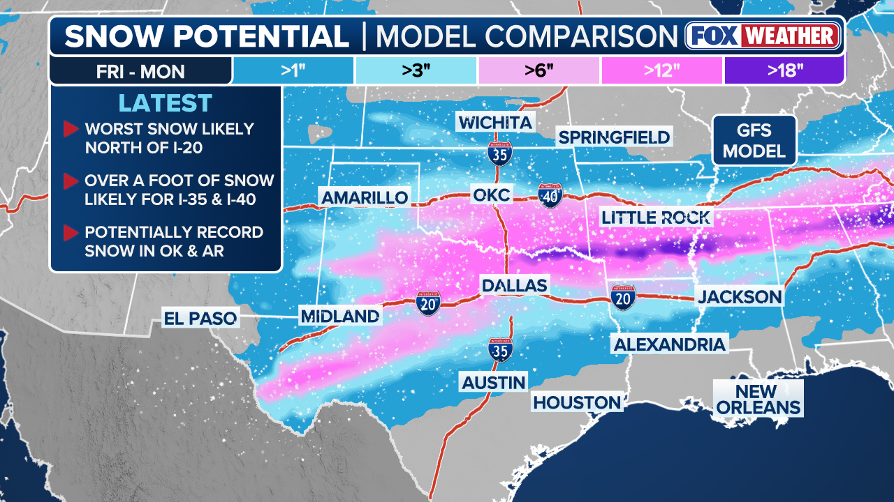
Southern Plains
Much of the Southern Plains are in the line for snow, ranging from less than an inch in southern Texas to a foot in localized areas of Oklahoma City.
While parts of Texas, such as Dallas, Fort Worth, Denton and Plano are sitting in the 1–3 inch range, cities like Norman and Edmond are expecting around 8–12 inches of snow.
(FOX Weather)
Central Plains and Midwest
Much of the Central Plains and Midwest are eyeing 3–8 inches of snow overall, with higher totals possible in localized areas.
Cities like Kansas City, Lincoln and Omaha could see 3–5 inches of fresh snow, while Sioux City is likely to only receive 1–3 inches.

(FOX Weather)
HOW TO SURVIVE IN YOUR CAR IF YOU’RE STUCK IN A WINTER STORM
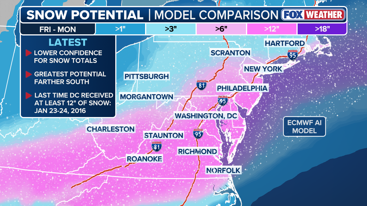
Mid-Atlantic
Much of the Mid-Atlantic is looking towards the higher end of snow accumulations, ranging from 6–12 inches of snow, with some localized areas seeing less, between 1–3 inches.
Cities like Washington, D.C., Richmond, Norfolk and parts of Philadelphia could potentially see at least 12 inches of snow and maybe more.
WHAT FACTORS GO INTO A SNOW DAY FOR SCHOOL DISTRICTS?
Northeast
While it’s still questionable if the storm’s track will fully impact the Northeast, much of the region has the potential to get slammed with a foot of snow or more.
New York City could see up to 18 inches of snow, along with Yonkers, White Plains and New Rochelle.
Some cities in New Jersey, such as Newark, Jersey City, and Patterson are eyeing totals closer to over a foot.
Meanwhile, interior Northeast cities like Syracuse and Binghamton, New York could see up to a whopping 2 feet of snow.
(FOX Weather)
Southeast
For most of the Southeast, snow chances remain mixed.
Many cities in Georgia and Alabama are all sitting in the less than an inch to 3 inch category, while Tennessee and North Carolina could see over a foot of snow.
(FOX Weather)
Stay tuned with FOX Weather as more updates will be made as the storm system develops.
Source link
editor's pick
latest video
Sports News To You
Subscribe to receive daily sports scores, hot takes, and breaking news!