Polar vortex: Parts of Lower 48 colder than Alaska, weeks of freezing temperatures ahead

Brutal cold has taken hold across the Northern Plains, Upper Midwest and parts of the Ohio Valley and interior Northeast. Cold Weather Advisories are in effect through Tuesday. Life-threatening wind chill temperatures between -20 and -40 degrees are expected across much of the Upper Midwest through the week. The artic air will reach the Northeast Coast by Tuesday.
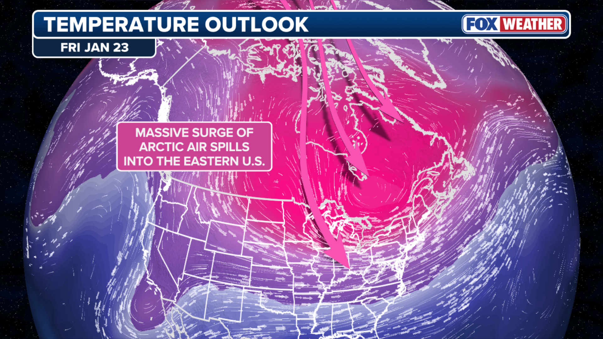
Dangerous life-threatening cold has spread over much of the Northern Plains, Midwest and parts of the Northeast, with another surge of arctic air expected to drop wind chill temperatures close to -40 degrees later this week — leaving some places in the Lower 48 colder than Alaska.
Part of the polar vortex, which contains some of the coldest air on the planet and is usually above the North Pole, has shifted south over much of the central and eastern U.S. and will usher in waves of subfreezing temperatures for much of the country at least through the beginning of February.
(FOX Weather)
Bitter cold reached the Northeast Tuesday, where roughly 65 million people experienced wind chill temperatures between -5 and -15 degrees.
This included the Cleveland and Pittsburgh metro areas, while New York City and parts of the northeastern Interstate 95 corridor woke up with low temperatures in the teens.
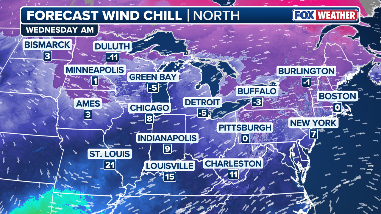
After a brief reprieve Wednesday for the Northeast, the coldest, bone-chilling air of the season will race into the Northern Plains and Midwest by Thursday.
Low temperatures will drop into the single digits and teens across much of the Upper Midwest on Wednesday. Detroit is expected to only reach 6 degrees.
(FOX Weather)
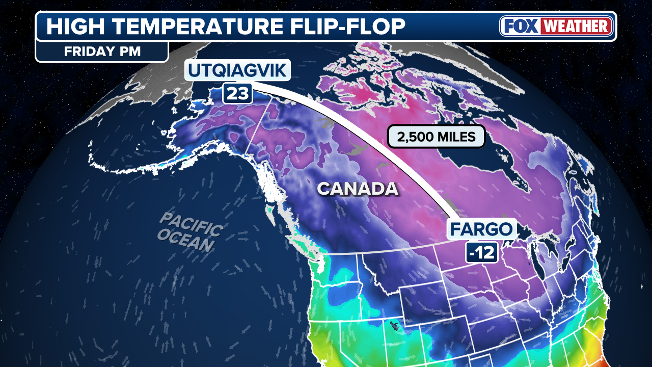
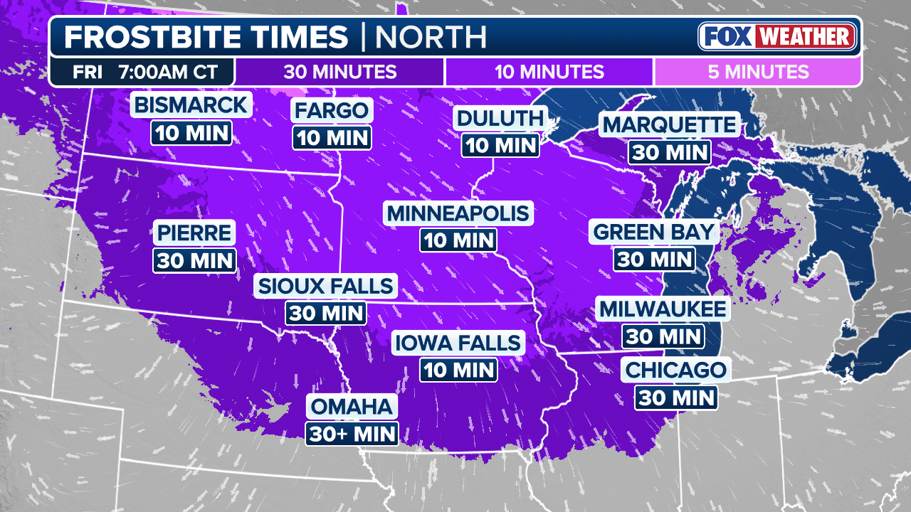
By Friday, conditions in the Dakotas will likely be the most frigid in the country.
Fargo, North Dakota will reach a high temperature of -13 degrees on Friday; meanwhile, Utqiagvik, Alaska, which is still experiencing Polar Night, will enjoy a comparatively balmy high of 23 degrees.
POLAR NIGHT BEGINS: ALASKA CITY WON’T SEE THE SUN FOR THE NEXT 64 DAYS
(FOX Weather)
Cold Weather Advisories have been issued for parts of the Upper Midwest and much of the Ohio Valley through Thursday, while an Extreme Cold Warning covers the Appalachians in West Virginia.
The extremely cold air will become lodged over the Northern Plains and Midwest, forming what’s known as an Arctic area of high pressure and where temperatures will remain below freezing through next week.
This second round of Arctic air will reach both the interior Northeast and I-95 corridor along the coast by late Friday. While this region will avoid the worst of the cold, millions will still experience days of wind chills in the teens, locking in a deep winter feel.
(FOX Weather)
Meanwhile, this Arctic high will become the main driver of a rare widespread winter storm that’s set to slam more than two dozen states and millions of people across the South beginning Friday.
How far south this Arctic high moves will determine which states see dangerous snow and ice.
Arctic air will linger through next week and could hamper potential power restoration efforts after the storm.
(FOX Weather)
Regardless, these temperatures themselves are life-threatening conditions and can cause frostbite in as little as 10 to 30 minutes.
Source link
editor's pick
latest video
Sports News To You
Subscribe to receive daily sports scores, hot takes, and breaking news!