
January U.S. Forecast: Freezing cold in Florida and rounds of snow return in U.S.

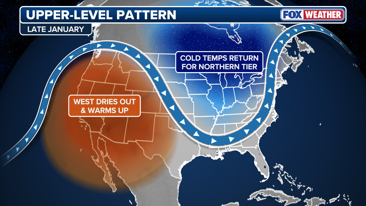
After a brief January thaw, winter will return with a vengeance for the rest of January across most of the eastern half of the U.S. with Arctic temperatures and rounds of snow for the Great Lakes and Interior Northeast. The winter chill will dip into parts of the Southeast where higher elevations in North Carolina and Tennessee could see snow as storms move across the region.
After a brief thaw, winter will return with a vengeance for the rest of January across most of the eastern half of the U.S. with Arctic temperatures and rounds of snow for the Great Lakes and Interior Northeast. The winter chill will dip into parts of the Southeast where higher elevations in North Carolina and Tennessee could see snow as storms move across the region.
Meanwhile, the West Coast will see mild conditions return after weeks of repeated atmospheric rivers caused historic flooding across parts of California and the Pacific Northwest.
Beginning Friday, a dip in the jet stream will drape over parts of the Upper Midwest and over the rest of the eastern U.S.

FILE – A snow plow clears a pathway from snow on February 9, 2025 in Boston, Massachusetts. (Photo by Scott Eisen/Getty Images)
(Getty Images)
According to the FOX Forecast Center, this dip will allow both Arctic air and repeated winter storms to spill into the Lower 48 from Canada.
“While none of these systems are expected to become blockbuster storms, they will restore the snowy and cold conditions,” the Forecast Center wrote Tuesday.
Bitter cold air will push deep into the Southeast, including Florida, where temperatures could be 15-20 degrees below average, sending iguanas plunging from trees as they get cold stunned.
-

FILE – A maintenance worker holds an iguana immobilized from cold temperatures outside an apartment complex in West Palm Beach, Florida, U.S., on Wednesday, Jan. 22, 2020. Cold-stunned iguanas fell from trees in South Florida Wednesday morning as temperatures in Miami hit 40 degrees and wind chills reached in the 20s and 30s in South Florida, The National Weather Service reported. Photographer: Saul Martinez/Bloomberg via Getty Images
( ) -

Iguanas typically begin to lose mobility when temperatures reach 50 degrees. Below that, the cold can completely immobilize them.
((Cristobal Herrera/South Florida Sun Sentinel/Tribune News Service via Getty Images)) -

File photo: An iguana immobilized from cold temperatures lays on grass in West Palm Beach, Florida, U.S., on Wednesday, Jan. 22, 2020. Cold-stunned iguanas fell from trees in South Florida Wednesday morning as temperatures in Miami hit 40 degrees and wind chills reached in the 20s and 30s in South Florida, The National Weather Service reported. (Photographer: Saul Martinez/Bloomberg via Getty Images)
( )
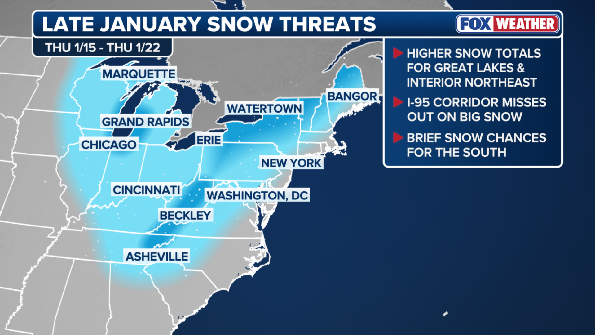
January snow expectations
This active pattern is a callback to much of December’s weather, where repeated snow even caught the attention of people in traditional snowbelts across the Midwest and the interior Northeast.
DRONE PHOTOGRAPHER FILMS SPECTACULAR FOOTAGE OF WINTER IN MICHIGAN
Syracuse, New York, which deals with lake-effect snow from Lake Ontario every year, has already received more than 83 inches of snow this snowfall year-to-date, the most in more than a decade.
(FOX Weather)
And many of these same snowbelts along the Great Lakes should expect to see multiple rounds of snow over the next two weeks, as storms dive out of Canada. Snow should be able to reach the southern Appalachians and temperatures may even become cold enough for brief winter weather in states like Alabama, Georgia, and the lower elevations of the Carolinas.
(FOX Weather)
Respite for the West
This pattern change will be a return to much-needed dry conditions across the West Coast, where weeks of atmospheric rivers have led to deadly historic flooding across parts of Washington and California.
While recent storms have brought necessary snow to the Cascade and Sierra mountain ranges, the wet conditions have also contributed to deadly avalanches.

FILE – PACIFIC, WASHINGTON – DECEMBER 16: In an aerial view, a neighborhood is engulfed in floodwater on December 16, 2025 in Pacific, Washington. Evacuations have been ordered in 3 suburbs south of Seattle after recent levee failure. Atmospheric rivers are expected to continue in the coming days as northern Washington continues reeling back from historic flooding late last week. Mass flooding along the Pacific Northwest caused historic flooding, tens of thousands of evacuations, and dozens of Coast Guard rescues.
((Photo by Brandon Bell/Getty Images) / Getty Images)
Weather whiplash for Southeast
A shocking return to the cold will be the most noticeable feature of this weather pattern shift for most.
SEE IT: 12-FOOT GREAT WHITE SHARK NAMED ‘ERNST’ PINGS OFF COAST OF ALABAMA THIS WEEK
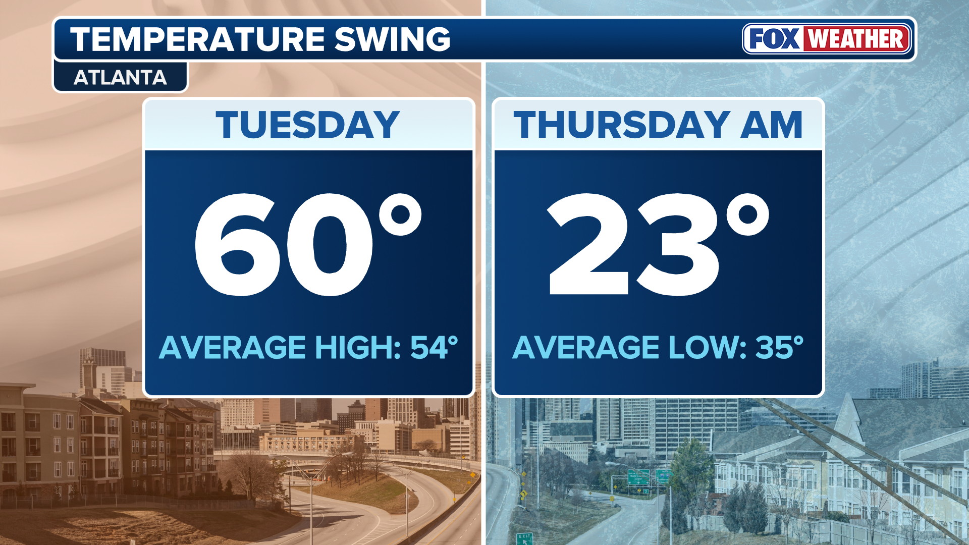
Since the New Year, most of the Lower 48 have enjoyed temperatures 5-10 degrees above average.
(FOX Weather)
After Atlanta reaches 60 degrees Tuesday, low temperatures across parts of the Southeast will plummet into the 20s by Thursday morning, marking the beginning of several weeks of winter chill for the eastern half of the country.
Source link
editor's pick
latest video
Sports News To You
Subscribe to receive daily sports scores, hot takes, and breaking news!