
Brewing nor’easter to ‘bomb’ out days after deadly storm raged across the US
Just days after a powerful, 2,300-mile long winter storm swept across the U.S. and dumped massive amounts of snow on areas, another winter system has the potential to form and hit the East Coast. The FOX Weather Forecast Center is monitoring a potential nor’easter that can “bomb out” and bring more snow and powerful coastal winds from the Carolina’s up to the Northeast.
Hot on the heels of a deadly major winter storm that carved its way 2,300 miles across the United States, bringing life-threatening ice and heavy snow to several areas, comes a potential nor’easter that has the strong likelihood to “bomb out.”
Regions like the Mid-Atlantic and Northeast saw significant snow over the weekend, and are beginning to dig out. Now, a nor’easter is forecast off the East Coast for this upcoming weekend, and is looking increasingly likely to develop into a bomb cyclone.
Given the ingredients current models are projecting, it is becoming nearly certain that a powerful storm will develop, though where it bombs has not been set in stone just yet.
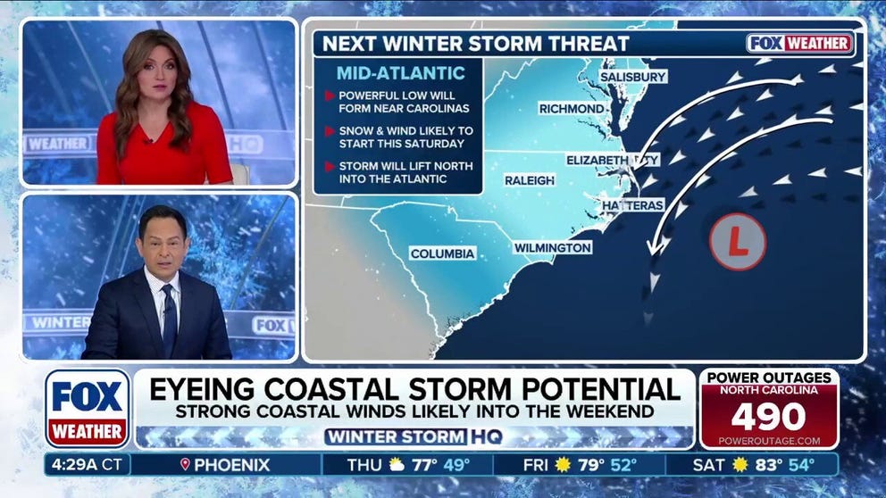
There is growing confidence in major snow slamming the Carolinas and Virginia, but from there, uncertainty remains regarding exactly where the storm tracks. The scenarios range from a crippling I-95 blizzard to a glancing blow.

A worker clears snow off a sidewalk in Philadelphia, Pennsylvania, on January 25, 2026.
((Photo by Matthew HATCHER / AFP via Getty Images) / Getty Images)
As much of the Northeast digs out from the biggest snowstorm in half a decade, New York, Philadelphia, and Boston could all be on track to see another major system on its heels.
Still days out from the storm, the necessary ingredients are setting the stage for an East Coast bomb cyclone that could bring more snow.

(FOX Weather)
TAKING SHAPE
This past weekend, a historic winter storm that stretched more than 2,300-miles across the U.S. impacted more than 235 million Americans across more than 35 states. This upcoming winter storm has a different origin story.

BOSTON, MASSACHUSETTS – JANUARY 25: A person walks through Boston Public Garden during heavy snow on January 25, 2026 in Boston, Massachusetts.
((Photo by Scott Eisen/Getty Images) / Getty Images)
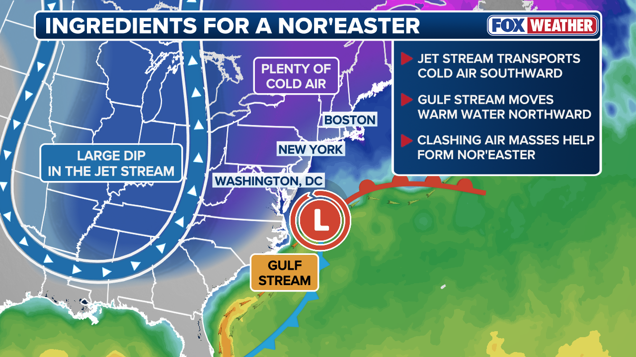
Last week’s event resulted from two separate pieces of energy phasing together, ultimately producing a large, cross-country storm system. In contrast, the setup for this weekend more closely resembles the development of a coastal low or a classic nor’easter forming along the Eastern Seaboard.
With a pronounced dip in the jet stream reinforcing cold air and suppressing the storm’s track farther south, a strong upper-level disturbance is expected to become embedded within the jet stream late in the week that could set the stage for the key ingredient: the development of an area of low pressure off the East Coast.
(FOX Weather)
Forecast models continue to show a stronger signal for a potential coastal storm, though uncertainty remains regarding the exact track as the system moves northward. At this time, confidence is highest in a low forming off the Carolina coastline heading into the weekend.
With colder air already in place, this setup could support snowfall along with increasingly strong winds as the system intensifies.
Should these forecast ingredients come together, it could set the stage for another snowstorm for the northeastern portion of the Interstate 95 corridor, which had been suffering from a decade-long snow drought in many locales before last weekend’s storm.
BUILDING THE BOMB
Still days out from the upcoming storm, there are still numerous scenarios on the table for how this storm plays out.
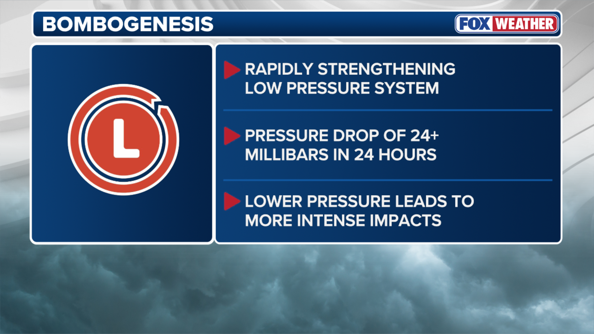
One notable aspect of this potential storm is the likelihood that it could rapidly strengthen, or “bomb out.”
(FOX Weather)
This process, known as bombogenesis, occurs when a storm’s central pressure drops at least 24 millibars in 24 hours. Current projections suggest the system could deepen from around 1008 millibars to near 970 millibars in just one day.
Such rapid intensification would create a very tight pressure gradient, leading to powerful winds and potentially hazardous conditions.
UNCERTAINTY AHEAD
The greatest uncertainty remains the storm’s track after impacting the Carolinas, though back-to-back weekend snow is possible in the Northeast, as forecast model guidance remains split on whether the storm will track into the region.
Days out from the weekend, the FOX Forecast Center is monitoring several scenarios on the table.
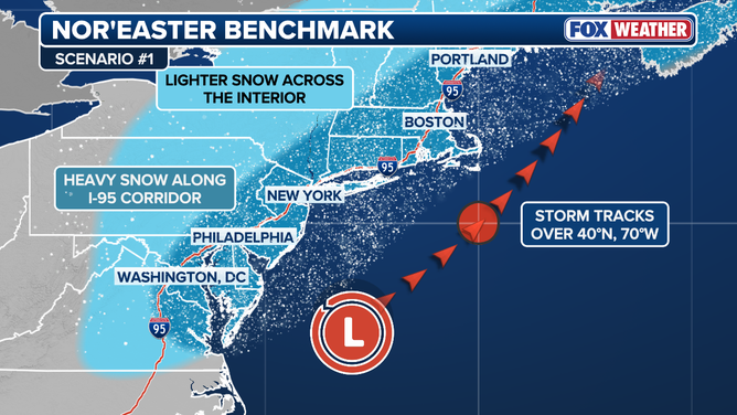
In this scenario, after the coastal low develops off the coast of the Carolinas and Virginia, the storm tracks past the “40/70 benchmark.” Which would likely produce significant snowfall along the I-95 corridor.
(FOX Weather)
For the Northeast, forecasters often reference the “40/70 benchmark,” located at 40°N and 70°W—roughly 80 to 100 miles southeast of Nantucket, Massachusetts. Historically, this position has been considered optimal for producing significant snowfall along the I-95 corridor.
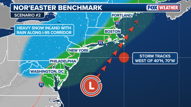
In this scenario, the storm tracks closer to the East Coat, which would bring rain to the I-95 corridor while producing heavy snow inland.
(FOX Weather)
Even if snowfall remains limited along the East Coast, gusty winds appear to be a primary concern and could result in coastal flooding or dangerous surf conditions.
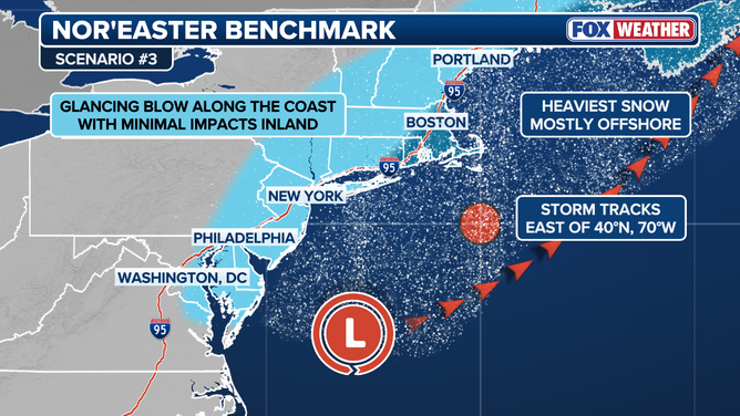
In this scenario, the coastal low tracks east into the Atlantic Ocean away from the East Coast, producing the heaviest snow mostly offshore. This outcome would provide a glancing blow of snow along the coast with minimal impacts inland.
(FOX Weather)
There is still much to monitor and refine, and a clearer picture of this potential system will emerge in the coming days. Stay tuned with FOX Forecast Center in the coming days to find out which East Coast states face the winter weather wrath the powerful storm has to offer.
Check back for updates on this developing story.
Source link
editor's pick
latest video
Sports News To You
Subscribe to receive daily sports scores, hot takes, and breaking news!