Nationwide arctic blast puts millions at risk for over 40 record lows

As cold air settles across the U.S., most of the country is experiencing subzero temperatures. Over 40 record low temperatures are possible across the Northern Tier.
Washington D.C. activated an Extreme Cold Alert on Thursday as overnight temperatures will be as low as 20 degrees with a wind chill.
An Extreme Cold Alert occurs when the National Weather Service (NWS) predicts temperatures that will pose an immediate risk to residents.
D.C. isn’t the only area experiencing frigid weather this week. Around 180 million Americans are in the middle of an arctic blast which is causing extreme freezing temperatures.
As of Thursday, most of the country had record lows and is expected to set more tomorrow.

Arctic blast outlook Tuesday through Saturday
(FOX Weather / FOX Weather)
Millions of Americans have already felt portions of this bitter arctic air from the Polar Vortex sweeping across the U.S.
When there is a disruption in the Vortex, it becomes weak and pushes colder air south towards Canada and the U.S.

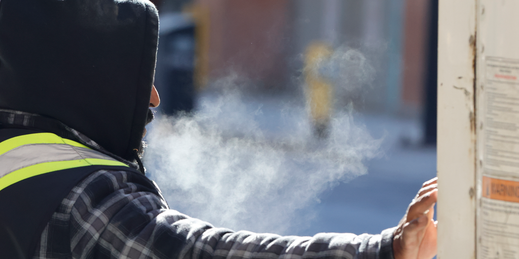
People walking through heavy snow in Chicago on Saturday.
(Robert Ray / FOX Weather)
On top of a La Niña winter, this has caused us to see typical temperatures for early February to appear in December.
This new wave of Arctic air has already brought colder temperatures than what most of the country saw on Monday, where a Cold Weather Advisory was in effect for northern Montana and wind chills caused it to feel 20 to 30 degrees below zero.
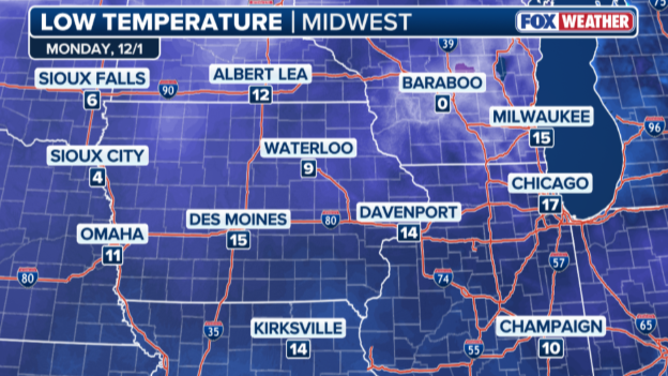
Temperature lows in the Midwest after the arctic blast on Monday, Dec. 1
(FOX Weather / FOX Weather)

Current temperatures in the Central U.S.
(FOX Weather / FOX Weather)
Many areas will stay at or below freezing, as the coldest air will linger over the High Plains and Upper Midwest, leaving cities like Chicago and Minneapolis to likely not climb above freezing for the duration of the week.
CHICAGO BRACES FOR THE ARCTIC BLAST AND A SECOND SNOWSTORM
According to the FOX Weather Center, today into Friday, things take a bigger shift Thursday, as the weather pattern evolves, ushering in a stronger blast of colder Arctic air. The push is even more frigid due to the colder temperatures leading up to the big blast.
The Midwest is the focal point for the coldest temperatures today, with the widespread outlook readings between 10 and below zero, as portions of the region are already feeling -28 to -31 degrees due to wind chill this morning.
Iowa and Minnesota reign as the first record-breakers today, bringing in four record lows for the cities of Waterloo, Sioux City, Cedar Rapids and Hibbing.
More potential records could also be broken for Des Moines, Cedar Rapids today.

Record lows so far today
(FOX Weather / FOX Weather)
By Friday, the heart of the cold will expand to the I-95 corridor, where more record lows may fall across cities like Pittsburgh, New York, Indianapolis and Baltimore.
Morning temperatures across the Midwest and Great Lakes will be in the single digits, while the I-95 corridor will reach the upper 20s, making it 15 to 25 degrees below average for this time of year.

Potential record lows for Friday set to hit parts of the country due to extreme arctic blast
(FOX Weather / FOX Weather)
In total, over 40 record low temperatures are possible across the Northern Tier for both today and Friday and below-average temperatures are expected to remain in some regions through mid-December.
Source link
editor's pick
latest video
Sports News To You
Subscribe to receive daily sports scores, hot takes, and breaking news!