Relentless impacts in Jamaica, Haiti, and the Dominican Republic forecast from Melissa
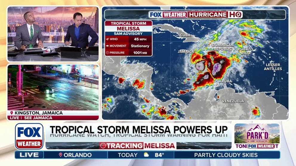
Tropical Storm Melissa is “nearly stationary,” according to the National Hurricane Center, but is still expected to deliver catastrophic flooding to Jamaica this weekend. See the latest forecast.
Updated Friday 9:30 a.m. ET
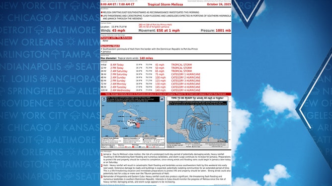
It’s increasingly likely that Jamaica will experience long-duration impacts from likely Hurricane Melissa like no storm they’ve encountered in modern times. Even if Melissa’s strongest winds stay offshore, and there’s no guarantee that that will happen, three or four days of relentless, heavy rain and gusty winds appear likely.
People should be in a safe spot by the end of tomorrow and be prepared to stay for at least three days.
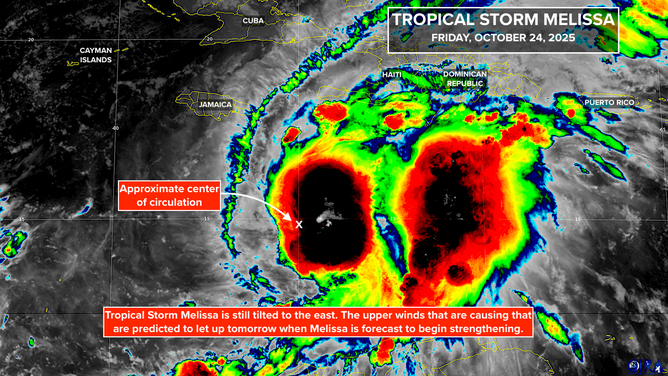
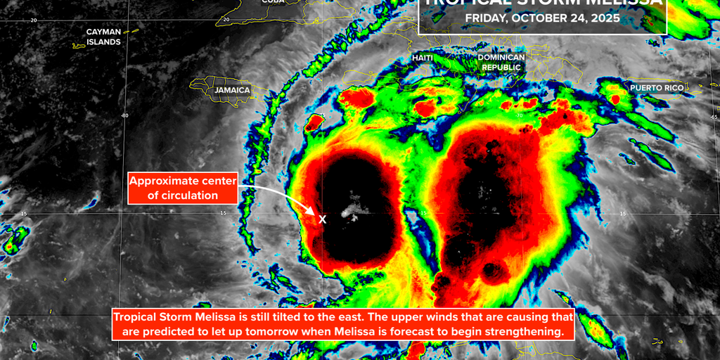
Tropical Storm Melissa is still ragged, but the computer analysis is that the atmospheric pattern over the storm is slowly becoming more conducive for it to organize and strengthen—the hostile upper winds are gradually letting up. It will take at least another day or a day and a half to pull itself together, but by tomorrow afternoon or tomorrow evening, the consensus of the various forecast models is that Melissa will be a hurricane.
There is a little short-term good news in the predicted track of Melissa’s core, where the strongest winds are located. The storm has been essentially stationary since yesterday instead of drifting north as forecast. This means that the storm center will be farther south when it starts moving west. A track offshore of the southern coast of the island would keep the strongest winds over the Caribbean, at least through the weekend.
Tropical Storm Melissa Info from NHC
(NOAA)
When a system is disorganized and moving little, forecasts always have higher errors, but this trend is good for at least the eastern half of the island.
The rest of the forecast is daunting, however. There is an increasing consensus that Melissa will make a hard turn to the north after the weekend, which could bring extremely strong wind over the western part of the island around Tuesday. Melissa is forecast to be a Category 4 hurricane at that time, and some computer forecasts show it a Cat 5.
The track can still shift, and let’s hope it shifts offshore, but the odds of a direct hit of extreme wind on top of days of gusty winds and steady rain are inching up.
Here is the exclusive FOX Weather Tropical Threat analysis. It shows a high-confidence track for the center south of Jamaica, but then a sharp turn early next week over or near the western tip of the island. The exact track over Cuba and the Southeastern Bahamas has lower odds because it is farther in the future.
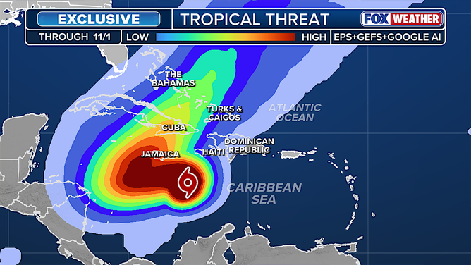
Melissa Tropical Threat
(FOX Weather)
Rain is also forecast to be relentless along the southern coast of Hispaniola—the island containing Haiti and the Dominican Republic. Southwestern Haiti looks to be the most vulnerable to catastrophic flooding and landslides.
Already, more than a foot of rain has fallen in the region around Santo Domingo, the capital of the Dominican Republic, which is on the south coast. Two to three feet of rain could fall in parts of Haiti, Jamaica, and possibly eastern Cuba.
Life-threatening impacts are likely, including flash flooding and mudslides from days of tropical rain. In addition, the rain weakens trees and power poles and makes them more susceptible to the even moderate-strength wind.
Everybody old enough in Jamaica remembers 1988’s Hurricane Gilbert, which devastated the island by tracking east to west just inland from the southern coast. Melissa will be different because of its slow forward motion—it will be more relentless. Hopefully the forecasts today end up being correct and the strongest winds stay south of much of the island, but the western third of Jamaica could still confront destructive winds next week.
Bands of heavy rain will continue on the south coast of Haiti and the Dominican Republic for a few days, at least. Puerto Rico is on the fringe of the moisture feed, but some flooding is possible. The Cayman Islands are likely to be west of the worst of the storm, but it could be close, so vigilance is required. In any case, there will be dangerous currents and waves throughout the islands.
Hurricane Melissa is forecast to turn north on Tuesday as it will increasingly be picked up by a strong dip in the jet stream over the Southeast U.S. That will take the storm over eastern Cuba and the Southeastern Bahamas, including possibly the Turks and Caicos Islands. Everyone there should stay informed.
The strength of the storm when it impacts Cuba and the Bahamas is unknowable because we don’t know how the mountains on Jamaica will affect the circulation. But there is a potential for Hurricane Melissa to be very strong when it passes over Cuba and through the Southeastern Bahamas. It will be accelerating, however, so it won’t be a relentless assault like Jamaica is likely to experience.
The only impacts in Florida are expected to be rip currents and dangerous surf on the East Coast, especially Palm Beach County and north. There is no threat of a direct hit on the state. In addition, the Gulf, Belize and Mexico’s Yucatan Peninsula are in the clear.
Nothing else is in the works in the tropics, and the odds favor this being the last card Mother Nature is going to play in Hurricane Season 2025.
Source link
editor's pick
latest video
Sports News To You
Subscribe to receive daily sports scores, hot takes, and breaking news!