Bryan Norcross hurricane analysis for Sept. 20, 2025

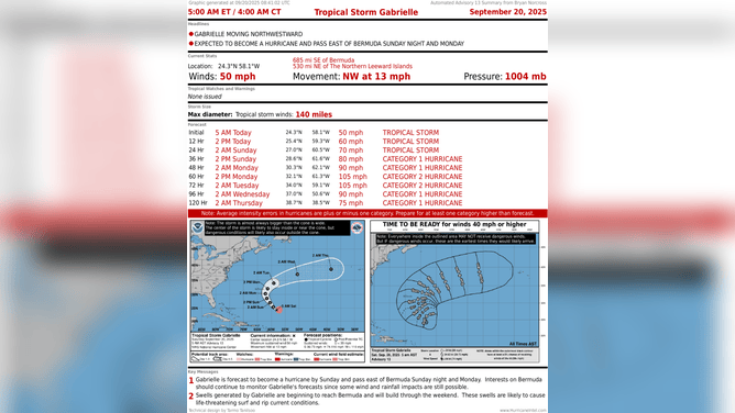
Eyes are on Tropical Storm Gabrielle, which is expected to strengthen into a hurricane by Sunday and pass just east of Bermuda. The NHC is also monitoring an area to watch on Gabrielle’s heels.
Updated Saturday, 10 a.m. ET
The hostile upper winds and dry air that have been keeping Tropical Storm Gabrielle from organizing are slowly letting up, though the system hasn’t intensified yet. The storm is developing thunderstorms near the center, which is the first step. Gabrielle is still expected to reach hurricane strength over the weekend.
If the forecast is right, Gabrielle will be our second hurricane of the season. It’s very unusual for a second hurricane to show up this late. In fact, it hasn’t happened since 1994. But we can’t draw any conclusions from that about the rest of the season.
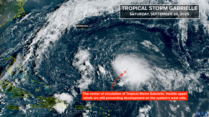
Tropical Storm Gabrielle Update
(NOAA)
Gabrielle is heading in the general direction of Bermuda, but there’s a strong consensus in the various computer model forecasts that it will miss the island to the east. The National Hurricane Center’s official forecast coincides with that thinking.
Strong swells emanating from the storm will build around Bermuda over the weekend, making boating and beachgoing dangerous. The storm should be moving away by late Monday and evolve into a strong non-tropical system in the North Atlantic.
In the Atlantic Near Africa
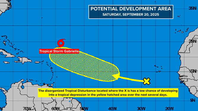
Tropical Storm Gabrielle Update
(NOAA)
The National Hurricane Center is still noting a tropical disturbance on the far side of the tropical Atlantic. Atmospheric conditions are generally hostile in that area, so the odds are low that it will develop even into a tropical depression next week as it heads in the general direction of the Caribbean islands.
Long Range Forecasts
In addition to the disturbance near Africa, there is another weak disturbance in front of it. The two disorganized systems are moving west more or less in tandem.
The first disturbance looks to reach the Caribbean islands about Tuesday as a moisture surge, with the second disturbance a few days behind it. There’s no sign that either system will be a significant threat to the eastern Caribbean, although we’ll watch the second system – the one the NHC is noting – to be sure.
Tropical Storm Gabrielle Update
(NOAA)
About next weekend, however, a number of the long-range computer forecast models have indicated that one or both of these systems could start trying to develop. The potential development zone has shifted today to north of Cuba and east of Florida.
The exclusive Fox Weather Tropical Threat analysis, which looks at the various plausible storm track scenarios from the European, U.S. GFS, and Google DeepMind AI models – shows the area of light and somewhat darker blue.
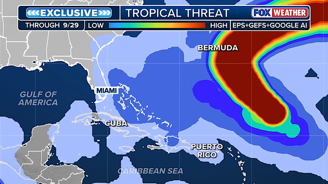
Tropical Storm Gabrielle Update
(FOX Weather)
The dark blue stripe next to Gabrielle’s track (shown in red) is a possible path for the second disturbance – a continuation of the NHC development area.
The consensus of the forecasts today is that another significant jet stream dip will settle over the Southeast in about a week and that will hold any systems offshore, although there’s a slight chance it will scoop a system out of the Caribbean if that first disturbance makes it that far.
The bottom line is, the odds of something menacing developing look lower today because of the forecasts for the strong jet stream dip – like we’ve lived with since August – over the Southeast and Florida.
We’re talking about long-range forecasts here, and this is why the National Hurricane Center normally doesn’t look beyond 7 days. We’ll continue to look at them of course, but our main goal is to understand the strengths and weaknesses of the two-week forecasts and especially the new AI models from Google and the European Center (the AIFS). They have shown significant progress but require rigorous evaluation.
Source link
editor's pick
latest video
Sports News To You
Subscribe to receive daily sports scores, hot takes, and breaking news!