Bryan Norcross: Atlantic goes quiet, Kiko looks to miss Hawaii

FOX Weather is your Hurricane HQ
(FOX Weather)
Updated at 9:30 a.m. ET on Sunday, Sept. 7, 2025
Good tropical news on this Sunday. The tropical disturbance we’ve been following in the Atlantic has apparently given up any dreams of developing. It’s still a cluster of healthy-looking thunderstorms, but there’s no sign of any organization.
In addition, between its location and the Caribbean is a large pool of extremely dry air. None of the various computer forecasts predict the system will survive the trek through that arid barrier. When the system arrives at the eastern Caribbean islands around next weekend, it looks likely to be a modest moisture surge with some gusty winds.
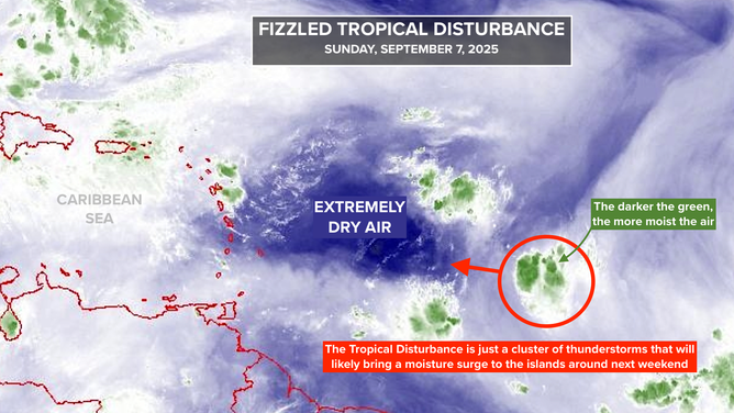
This image shows the water vapor in the tropical Atlantic on Sunday, Sept. 7, 2025.
(FOX Weather)
It’s highly unusual for a disturbance to go from a 90% chance of development to no chance in just over a day. If it’s going to happen, this is the type of disturbance that will do it. A small system surrounded by dry air is living on the knife’s edge. If it pulls in a little more moisture, it can quickly develop. But if dry air makes it into the nascent circulation, the works gum up easily.
There is nothing else to look at in the Atlantic at the moment. The next systems forecast to move off Africa do not look concerning. We’ll keep an eye on the western Caribbean and southern Gulf. When dips in the jet stream are very sharp and extend far south, like we’re seeing now, sometimes they can trigger systems to develop in that region. That’s not a forecast, just a general observation.
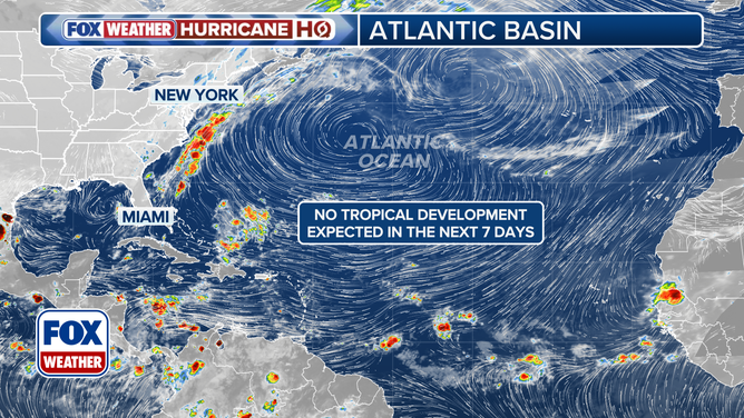
This graphic provides an overview of the tropical Atlantic Basin on Sunday, Sept. 7, 2025.
(FOX Weather)
It’s not obvious why the Atlantic is so hostile to tropical development. The pattern that goes around the Earth that alternately enhances and suppresses tropical activity seems to be in a supportive phase. But the extremely wavy jet stream is injecting very dry air into the tropics along with hostile upper winds.
We assume that it’s a phase like we saw last year when development was suppressed for weeks and then came roaring back, but we’ll see.
In the Pacific
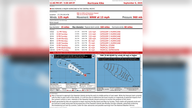
This graphic shows the latest with Hurricane Kiko as it approaches Hawaii on Sunday, Sept. 7, 2025.
(FOX Weather)
Hurricane Kiko is still going strong, although it’s begun its weakening phase. The good news is that the consensus of the computer forecasts is that the worst of the storm will stay well north of the Hawaiian Islands.
Large, dangerous surf will begin to impact the islands today, however. In addition, a Coastal Flood Watch is in effect because of the extra high tides due to the lunar cycle. Use caution in low-lying coastal areas, and remember, a saltwater puddle is terrible for your car.
Moisture from the edge of Kiko will spread across the islands beginning tomorrow. Nothing more than a moisture surge is expected, but everybody in the islands should stay in touch with the forecast just to be sure the storm track doesn’t change.
Source link
editor's pick
latest video
Sports News To You
Subscribe to receive daily sports scores, hot takes, and breaking news!