Hurricane Kiko’s close approach prompts Hawaii to declare state of emergency
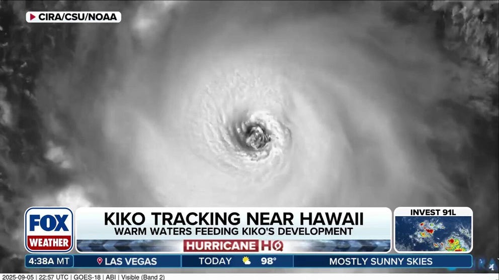
Kiko was still a Category 4 storm Saturday morning as it swirled about 1,000 miles east of Hawaii, but forecasters are confident the storm will lose a lot of punch before it nears the islands.
HONOLULU – Hawaii’s acting governor declared a statewide state of emergency as Hurricane Kiko continues to swirl toward the islands as a major hurricane.
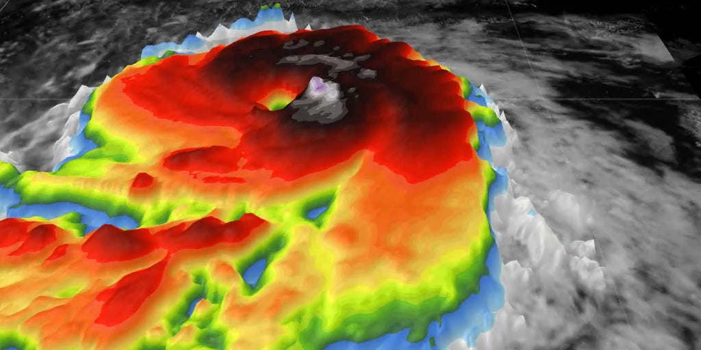
Kiko was still at Category 4 strength Saturday morning as it sat just over 1,000 miles east of Hilo, with peak winds estimated at 140 mph, according to the National Hurricane Center.

(FOX Weather)
Forecasters are still confident the storm will weaken considerably by the time it gets close to the islands early next week and enters cooler Pacific Ocean waters, but may still remain a powerful tropical storm carrying potential for heavy rain and large, dangerous surf.
HURRICANE INIKI 30 YEARS LATER: HOW A MONSTER STORM IN HAWAII IMPACTED FILMING OF JURASSIC PARK
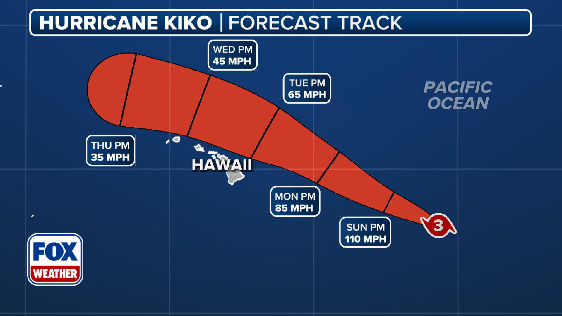
The current forecast track indicates the storm will likely pass just to the north of the islands on Tuesday, and the odds of a direct landfall strike are very low. But large swells are expected to begin affecting the Big Island as early as Sunday.
(FOX Weather)
“These swells will gradually build and are forecast to peak along east-facing exposures of the Hawaiian Islands late Monday through midweek, potentially producing life-threatening surf and rip currents,” the NHC wrote in its Saturday morning tropical update.
In addition, heavy rains could batter the islands if Kiko passes close enough.
Acting Hawaii Gov. Sylvia Luke says the state isn’t taking any chances and is urging residents to monitor the forecasts. Luke’s emergency proclamation mobilizes state agencies and the Hawaii National Guard.
“To ensure the safety and preparedness of our communities, the state and counties will stand ready to mobilize resources to clear debris, secure infrastructure, and respond quickly to any possible damage caused by the storm,” Luke said.
Hurricane Kiko to begin weakening on Sunday
Hurricane Kiko has been varying between a Category 3 and 4 storm since Thursday as it fed off the toasty warm waters of the tropical Pacific Ocean.
WHAT IS AN ANNULAR STYLE OF HURRICANE?
The NHC says Kiko will likely remain a major hurricane through the weekend. But then the storm will find much less hospitable conditions for survival, and the storm will begin to lose strength.

(FOX Weather)
Satellites estimate that sea surface temperatures between the hurricane’s current location and the Big Island of Hawaii are in the mid-70s, which is considered several degrees cooler than what a cyclone typically needs for strengthening. In addition, Kiko is about to run into more hostile upper-level winds and drier air, working in tandem to sap even more strength.
Current forecasts predict Kiko will drop to minimal hurricane strength by Monday night, then likely be downgraded to a tropical storm by Tuesday morning as it makes its closest approach to the islands.
7 FACTS TO KNOW ABOUT HURRICANES
Kiko is expected to continue to weaken as it churns to the north of Hawaii during the day Tuesday.
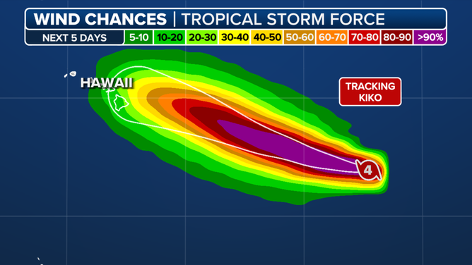
Also limiting the storm’s impacts is the storm’s relative small size. Hurricane-force winds only extending outward 25 miles and tropical-storm-force winds extending outward up to 80 miles, meaning that chances are fairly low that Hawaii will see damaging wind impacts.
“Because the circulation is small, and even the Big Island is a relative speck in the vastness of the ocean, a slight deviation in Kiko’s track will make a dramatic difference in the weather that impacts Hawaii,” said FOX Weather Hurricane Specialist Bryan Norcross. “We won’t really have a good idea about that until the storm gets closer, but right now, the consensus if that Kiko’s center will pass just north of the islands with most of the moisture and wind offshore.”
Source link
editor's pick
latest video
Sports News To You
Subscribe to receive daily sports scores, hot takes, and breaking news!