Bryan Norcross: Atlantic disturbance fizzles while Hawaii watches Kiko

FOX Weather is your Hurricane HQ
(FOX Weather)
Updated Saturday, 11 a.m. ET
The tropical system we’ve been following in the Atlantic – Invest #91L – is trapped in dry and dusty air and has been unable to get organized. In addition, the system’s slow movement has been a negative factor in its potential development.
The net result is that the National Hurricane Center has dramatically lowered the odds that the system will develop even into a tropical depression by the time it reaches the vicinity of the Caribbean islands. The odds are now in the low range.
Interestingly, the system is producing more thunderstorms this morning than it was yesterday. We’ll see if that trend continues, or they fizzle out again.
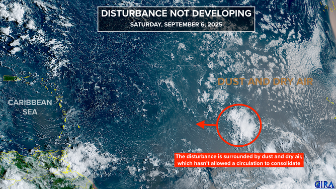
Satellite image of the disturbance.
(CIRA / FOX Weather)
The various computer models have universally backed off developing the system. Some dissipate it completely, some turn it north as a blob of moisture before reaching the islands, and some bring it into the Caribbean as a gusty moisture surge affecting the islands around the middle of next week.
Interestingly, two of the AI forecast systems – the European AIFS model and the Google DeepMind model – that we look at were the first to predict that the system would not develop in any significant way. Recall that the traditional European and GFS models were predicting a big hurricane in the Southeast in their long-range forecasts for a while. There are no conclusions to draw from this observation, but it’s a data point. This is our first season rigorously using the AI models, so we are learning their strengths and weaknesses.
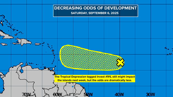
Decreasing odds of development.
(National Hurricane Center / FOX Weather)
Note that the odds of development are still not zero, so everybody in the islands should continue to stay informed. The weather pattern, except for the dry air, looks conducive for development, at least until the system is in the vicinity of the islands. If it can find a patch of moist air, or generate enough thunderstorms to make its own bubble of moisture, it could still spin up.
In any case, nothing is going to happen fast. Let’s see how the system does over the weekend.
In the Pacific
Fierce Hurricane Kiko is still roaring in the general direction of the Hawaiian Islands. The storm has a doughnut-like structure, which is called annular. As a result, the weakening process that we normally see when a storm moves over cooler water is expected to be slower.
Kiko is at Category 4 strength now and is forecast to only slowly weaken on its approach to the waters near or north of the Big Island about Tuesday.
Swells from the hurricane are expected to reach the Big Island and Maui tomorrow and spread west through the Hawaiian chain next week.
At the current time, the odds favor the core of the storm passing sufficiently north of the islands that the worst of the weather will stay well offshore. But that’s not yet guaranteed. Everybody in Hawaii should stay in touch with the latest on Kiko.
Source link
editor's pick
latest video
Sports News To You
Subscribe to receive daily sports scores, hot takes, and breaking news!