Hurricane forecasters now tracking triangle of tropical trouble as Atlantic Basin bubbles with activity

As Hurricane Erin swirls off the mid-Atlantic coast, the NHC is now watching three other systems for tropical development.
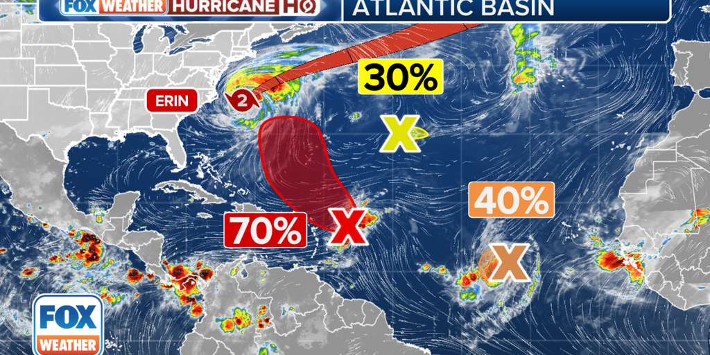
MIAMI – The Atlantic Ocean is starting to get crowded with tropical troublemakers, and a new area of thunderstorms just caught the attention of the National Hurricane Center (NHC) to monitor for development.
Hurricane Erin continues to lead the parade as the massive storm slowly swirls off the mid-Atlantic coast, slamming the coasts with powerful waves, dangerous rip currents and damaging storm surge. Forecasters are also now keeping a wary eye on three other systems farther out in the Atlantic that could have inklings of developing into their own named storms.

(FOX Weather)
The system with the greatest odds of eventually becoming at least a tropical depression, if not Tropical Storm Fernand, is cluster of showers and thunderstorms a few hundred miles east of the Leeward Islands. The NHC just designated this system as Invest 90L late Thursday morning, allowing forecasters to run additional computer models runs to track the disturbance.
This batch of tropical clutter hasn’t changed much in the past day, but the NHC still gives high odds it will become a tropical depression this weekend while it moves near or to the north of the northern Leeward Islands.
BRYAN NORCROSS: HURRICANE ERIN’S IMPACTS ON US EAST COAST WILL INCREASE THROUGH THE DAY
“The consensus of the various computer forecasts is that the system will be in the vicinity of the northeastern Caribbean islands Friday or Saturday,” FOX Weather Hurricane Expert Bryan Norcross said. “None of the computer model predictions show an especially strong system, but a number show a depression or Tropical Storm Fernand. If this system does develop, it looks most likely to happen after it has turned north of the islands, but we’ll have to watch to be sure.”

(FOX Weather)
Norcross said, like Erin, 90L should stay well east of the U.S. coastline – in fact, some model tracks take it even farther offshore, even east of Bermuda.
“That’s certainly not 100% because it depends on how strong the system becomes and when, but the steering pattern looks strong,” Norcross said.
Invest 99L: Dawdling in the central Atlantic
Meanwhile, the tropical wave that has been tagged as Invest 99L as it tracks several hundred miles west-southwest of the Cabo Verde Islands is showing some signs of organization, the NHC said. But unlike Erin and 90L, Invest 99L’s prospects for a long life are dim.

(FOX Weather)
Invest 99L will find atmospheric conditions “marginally favorable” for development over the next day or so as it journeys west-southwestward. But with more hostile atmospheric conditions looming on the path ahead, the NHC said a short-lived tropical depression is about the ceiling for its development.
But Norcross says it’s always good to keep an eye on it.
“The fundamental rule applies to both these systems: all forecasts for undeveloped or just developing systems are subject to large errors and are likely to change,” he said. “So don’t hang your hat on anything yet.
If, by chance, the system manages to squeeze out enough development to reach tropical storm status, it would take the name Gabrielle (provided that other storm takes “Fernand” first.)
Officially, the NHC is maintaining a medium chance for development.
Third area to watch joins a crowded map
As if there wasn’t enough traffic in the Atlantic, the NHC has now highlighted a third area to monitor, now making a virtual triangle of tropical trouble, shoehorned north between Invests 90L and 99L.

(FOX Weather)
The small area of low pressure is located about 1,200 miles southwest of the Azores and is producing limited showers and thunderstorms, the NHC said in its Thursday morning tropical update announcing the new spot on the map.
“Upper-level winds are only marginally conducive for development while the system moves slowly eastward over the next couple of days,” the NHC wrote.
The agency gave initial development odds in the low category within the next week. Unlike the other tropical trouble spots, this cluster of storms is drifting to the east farther out into the Atlantic.
Source link
editor's pick
latest video
Sports News To You
Subscribe to receive daily sports scores, hot takes, and breaking news!