Hurricane Erin barrels across Atlantic bringing life-threatening impacts to Caribbean
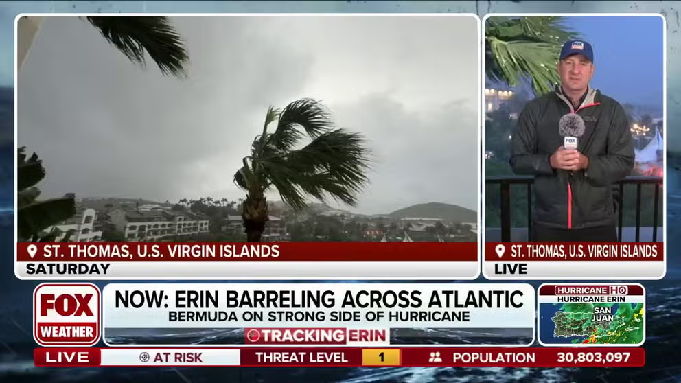
Hurricane Erin is barreling across the Atlantic to the north of the Caribbean islands, like Puerto Rico and the U.S. Virgin Islands, but impacts are being felt as the monster storm moves by. FOX Weather Correspondent Robert Ray is on St. Thomas in the U.S. Virgin Islands with the latest.
SAN JUAN, Puerto Rico – An eyewall replacement cycle is underway within Hurricane Erin as the monster storm continues to barrel across the Atlantic while bringing gusty winds and rain to Puerto Rico and the U.S. Virgin Islands after rapidly intensifying into a catastrophic Category 5 hurricane over the weekend.
The first major hurricane of the 2025 Atlantic hurricane season rapidly intensified from a Category 1 hurricane to a Category 5 hurricane with winds of 160 mph within hours before the storm began to lose some of its intensity but remained extremely dangerous as it began to move north of the Caribbean islands.

(FOX Weather)
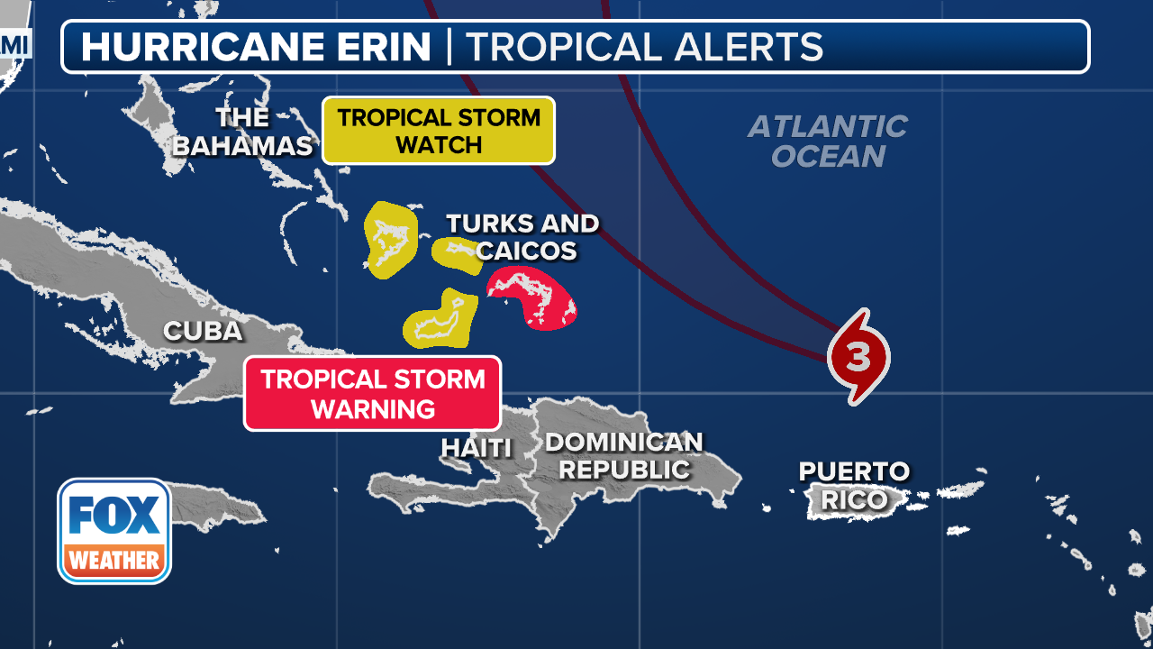
As of the latest advisory from the National Hurricane Center (NHC), Hurricane Erin remains a major Category 3 hurricane with winds of 125 mph as the storm continues to move off to the west-northwest at 14 mph.
Hurricane Erin is expected to continue to move off to the west-northwest on Sunday with a decrease in forward speed before a gradual turn to the north on Monday and Tuesday.
-

Heavy waves are seen at La Pared beach as Category 5 Hurricane Erin approaches in Luquillo, Puerto Rico on August 16, 2025. Hurricane Erin rapidly strengthened offshore to a “catastrophic” Category 5 storm on August 16, as rain lashed Caribbean islands and weather officials warned of possible flash floods and landslides. The first hurricane of what is expected to be a particularly intense Atlantic season, Erin is expected to drench Caribbean islands with rain and strong winds but not make landfall. (Photo by Ricardo ARDUENGO / AFP) (Photo by RICARDO ARDUENGO/AFP via Getty Images)
( ) -

Waves hit a structure as Category 5 Hurricane Erin approaches in San Juan, Puerto Rico, on August 16, 2025. Hurricane Erin on Saturday strengthened to a “catastrophic” Category 5 storm as it barrelled towards the Caribbean, with weather officials warning of possible flash floods and landslides. (Photo by Ricardo ARDUENGO / AFP) (Photo by RICARDO ARDUENGO/AFP via Getty Images)
( ) -
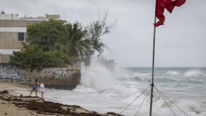
A ripped red flag warning of rip current waves as Category 5 Hurricane Erin approaches in San Juan, Puerto Rico, on August 16, 2025. Hurricane Erin on Saturday strengthened to a “catastrophic” Category 5 storm as it barrelled towards the Caribbean, with weather officials warning of possible flash floods and landslides. (Photo by Ricardo ARDUENGO / AFP) (Photo by RICARDO ARDUENGO/AFP via Getty Images)
( ) -

Rain lashes St. Thomas as Hurricane Erin moves north of the U.S. Virgin Islands on Saturday.
(Robert Ray) -

Rain lashes St. Thomas as Hurricane Erin moves north of the U.S. Virgin Islands on Saturday.
(Robert Ray) -

Rain lashes St. Thomas as Hurricane Erin moves north of the U.S. Virgin Islands on Saturday.
(Robert Ray) -

Rain lashes St. Thomas as Hurricane Erin moves north of the U.S. Virgin Islands on Saturday.
(Robert Ray)
The center of Hurricane Erin is forecast to pass to the east of the Turks and Caicos Islands and the southeast Bahamas on Sunday night and Monday.
Hurricane Erin is currently located more than 150 miles north of San Juan, Puerto Rico, and more than 300 miles to the east-southeast of Grand Turk in the Turks and Caicos Islands, where a Tropical Storm Warning is in effect.
DOWNLOAD THE FREE FOX WEATHER APP

(FOX Weather)
A Tropical Storm Watch has been issued for the southeast Bahamas.
While the Caribbean islands were spared a direct hit from the catastrophic impacts of Hurricane Erin, conditions remain extremely dangerous over Puerto Rico and the Virgin Islands as outer bands lashed the region with gusty winds and heavy rain.
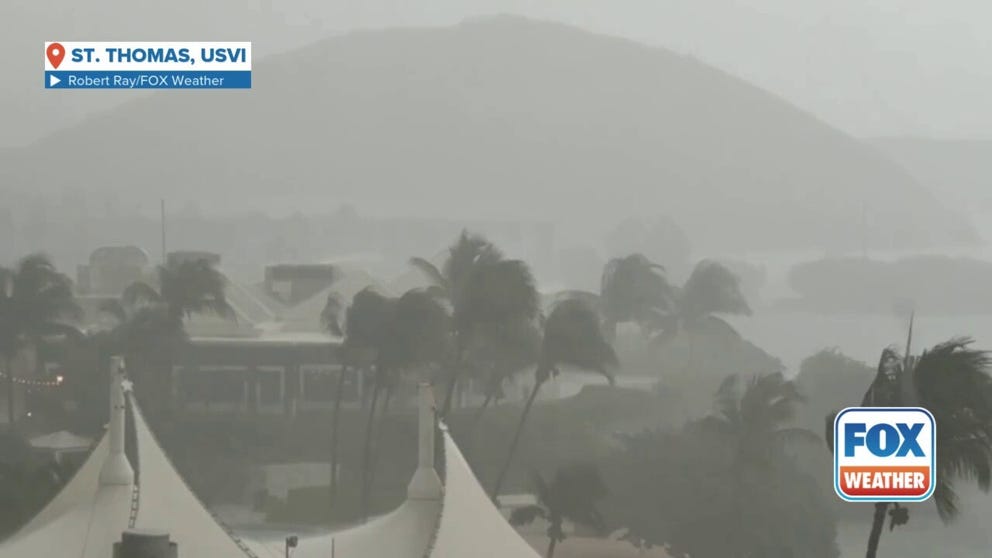
FOX Weather Correspondent Robert Ray shared this video of strong winds and heavy rain on St. Thomas in the U.S. Virgin Islands as Hurricane Erin passed to the north on Saturday, Aug. 17, 2025.
The NHC said those outer bands will continue to impact the area on Sunday, and forecast rain totals of 3-6 inches, with isolated totals of up to 8 inches, are expected.
Forecasters warned that locally “considerable flash and urban flooding,” as well as landslides and mudslides, are possible.
Squalls with wind gusts to tropical storm-force could also occur over portions of the Virgin Islands and Puerto Rico on Sunday.
(FOX Weather)
In addition, tropical storm conditions are expected within the Tropical Storm Warning area in the Turks and Caicos Islands starting Sunday night, with tropical storm conditions possible in the watch area in the southeast Bahamas later Sunday night and on Monday.
But it isn’t just the relentless rain and wind that could be life-threatening.
Ocean swells generated by Hurricane Erin will continue to affect portions of the Virgin Islands, Puerto Rico, Hispaniola and the Turks and Caicos Islands over the next few days.

Officials believe the island is ready to go for impacts from the weather during the workweek. Hurricane Erin is expected to pass between North Carolina and Bermuda as a major hurricane.
Massive swells will spread to the Bahamas, Bermuda, the East Coast of the United States and Atlantic Canada during the early to middle portion of the upcoming workweek.
Those rough conditions will also likely lead to life-threatening rip currents along East Coast beaches.
Will Hurricane Erin hit the U.S.?
(FOX Weather)
Some of Hurricane Erin’s impacts will be felt on the East Coast from Florida to New England, although a direct hit isn’t expected.
Coastal communities should be on alert for dangerous surf conditions producing massive waves and deadly rip currents through next week.
Such dangerous impacts could lead to beaches being closed and boaters should be aware of the marine conditions, FOX Weather Hurricane Specialist Bryan Norcross said.
“Hurricane Erin will generate huge waves in the open ocean and impart energy to the water that will radiate toward the coast in the form of strong, long-period swells,” Norcross said. “This energy will create powerful waves capable of eroding beaches and extremely strong and intense ocean currents.”
Source link
editor's pick
latest video
Sports News To You
Subscribe to receive daily sports scores, hot takes, and breaking news!