
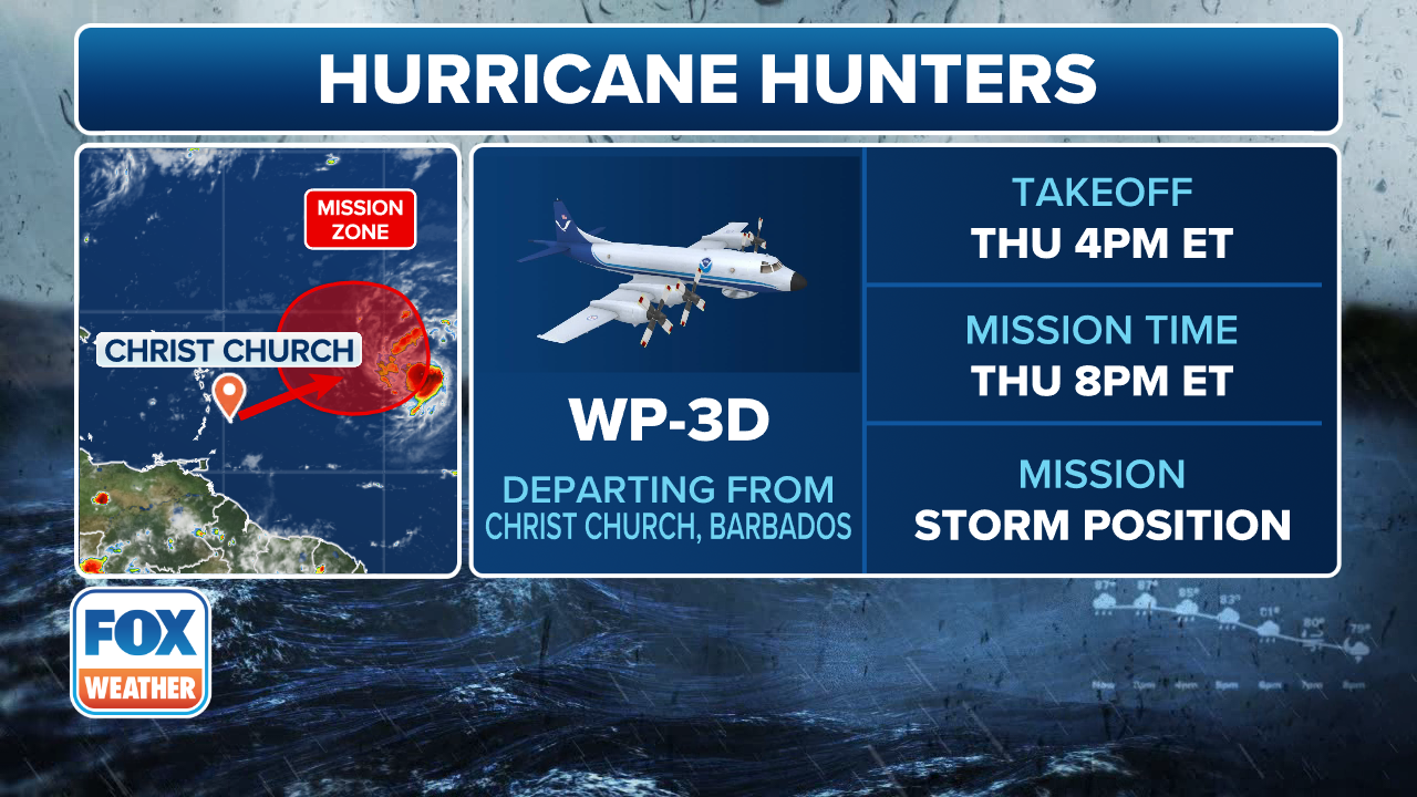
Tropical Storm Erin to be investigates by Hurricane Hunters on Thursday

The National Hurricane Center said that Tropical Storm Erin is moving into a more favorable environment and is becoming better organized, and forecasters say it could rapidly intensify this weekend as Hurricane Hunters get set to fly into the system on Thursday. FOX Weather Meteorologists Britta Merwin and Craig Herrera have the latest forecast on Aug. 14, 2025.
MIAMI – After fighting cooler ocean waters and Saharan dust, Tropical Storm Erin is now starting to become better organized and could rapidly intensify as Hurricane Hunters get set to fly into the strengthening storm on Thursday.
While at this point it doesn’t appear as though the Leeward Islands, the Virgin Islands or Puerto Rico will take a direct hit from soon-to-be Hurricane Erin, preparations for potential impacts are underway nonetheless.
(FOX Weather)
Officials in the U.S. Virgin Islands said territory-wide sandbag distribution for hurricane season was set to begin in a matter of days, but with Tropical Storm Erin spinning across the Atlantic, those plans were accelerated.
“Due to the projected impact of Tropical Storm Erin on the U.S. Virgin Islands, the Virgin Islands Territorial Emergency Management Agency (VITEMA), in partnership with the Virgin Islands Fire and Emergency Services, the Department of Public Works, the Office of ADA Coordinator, and the Department of Human Services, has accelerated the territory-wide sandbag distribution program,” officials said in a Facebook post.
“While the exact impact of Tropical Storm Erin remains uncertain at this time, VITEMA is taking proactive measures to ensure all residents have access to critical hurricane preparedness resources before the storm’s arrival.”
Officials said this accelerated distribution represents the only sandbag distribution for the 2025 hurricane season.
“We strongly encourage all residents to take advantage of this opportunity to protect their homes and property,” officials said.
The U.S. Coast Guard also isn’t taking any chances and said that it implemented Port Condition Whiskey for seaports in Puerto Rico and the U.S. Virgin Islands on Wednesday.
During Port Condition Whiskey, port facilities are currently open to all commercial traffic and transfer operations may continue. But pleasure craft have been advised to seek safe harbor.
Port facilities have been told to review and update heavy weather response plans and make any additional preparations that are needed to prepare for any potential impacts.
-

Flooding damage on the island of São Vicente, Cape Verde on Aug. 11, 2025.
(Angelo Barbosa/Facebook ) -
Flooding damage on the island of São Vicente, Cape Verde on Aug. 11, 2025.
(Angelo Barbosa/Facebook ) -

Flooding damage on the island of São Vicente, Cape Verde on Aug. 11, 2025.
(Angelo Barbosa/Facebook ) -

Flooding damage on the island of São Vicente, Cape Verde on Aug. 11, 2025.
(Angelo Barbosa/Facebook ) -

Flooding damage on the island of São Vicente, Cape Verde on Aug. 11, 2025.
(Angelo Barbosa/Facebook ) -

Flooding damage on the island of São Vicente, Cape Verde on Aug. 11, 2025.
(Angelo Barbosa/Facebook ) -

Flooding damage on the island of São Vicente, Cape Verde on Aug. 11, 2025.
(Angelo Barbosa/Facebook ) -

Flooding damage on the island of São Vicente, Cape Verde on Aug. 11, 2025.
(Angelo Barbosa/Facebook )
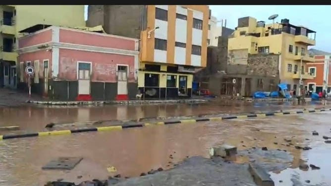
Tropical Storm Erin has already impacted other areas, including in the Cabo Verde Islands off the coast of Africa, where several people, including children, were killed when the system was known at Invest 97L.
DOWNLOAD THE FREE FOX WEATHER APP
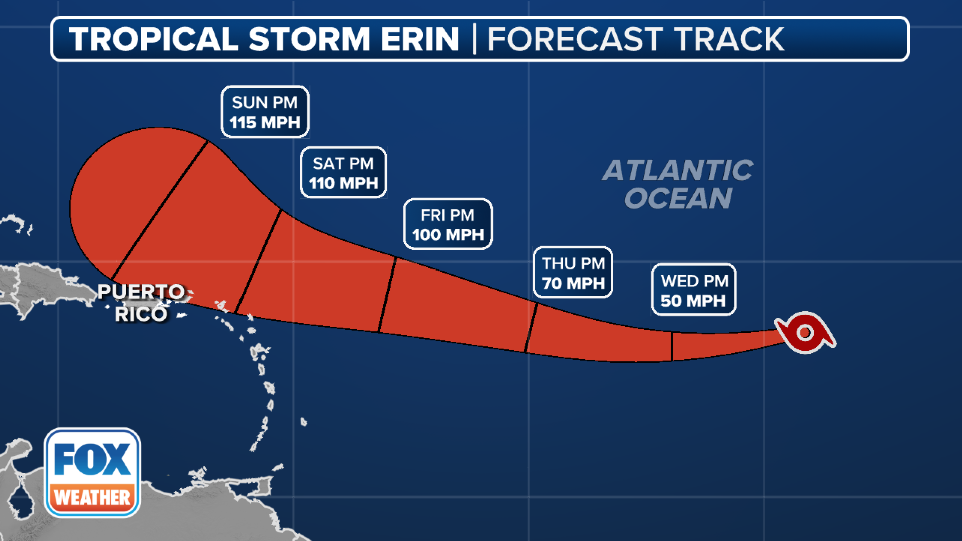
Latest Tropical Storm Erin forecast

(FOX Weather)
The National Hurricane Center (NHC) said winds within Tropical Storm Erin have reached 50 mph with some higher gusts, and gradual strengthening is forecast over the next day or so, with more significant intensification possible on Friday and Saturday.
Erin is expected to become a hurricane by Friday, and is forecast to become a major hurricane (Category 3 or higher) over the weekend.
“The environment around Erin should remain conducive during the next day or so, which will likely promote gradual strengthening,” the NHC said. “Thereafter, the storm is forecast to move across warmer waters, with potentially a decrease in shear. This evolution results in a period of potential rapid intensification late this week.”
According to the NHC, rapid intensification occurs when a tropical cyclone’s maximum sustained winds increase by at least 35 mph in a 24-hour period.
Tropical Storm Erin is currently located more than 900 miles to the east of the northern Leeward Islands and is moving off to the west at 17 mph.
That general motion is expected to continue on Thursday, with a west-northwestward motion starting on Thursday night and continuing into the weekend.
(FOX Weather)
On that forecast track, the center of Tropical Storm Erin is likely to move near or just north of the northern Leeward Islands over the weekend.
“Locally heavy rainfall, high surf and rip currents, and tropical-storm-force winds could occur over portions of the northern Leeward Islands, the Virgin Islands and Puerto Rico into this weekend as the core of Erin passes north of those islands,” the NHC said.
And while it’s still uncertain exactly what impacts may occur in portions of the Bahamas, the U.S. East Coast and Bermuda next week, the NHC said the risk of dangerous surf at the beach and potentially deadly rip currents across the western Atlantic basin next week is increasing.
“As we approach the climatological peak of hurricane season, this is an opportune time to ensure your preparedness plans are in place,” the NHC warned.
Source link
editor's pick
latest video
Sports News To You
Subscribe to receive daily sports scores, hot takes, and breaking news!