Flash flooding threat digs deeper into South as powerful front brings week-plus of heavy rains

A potent cold front will stall across the Southeast and Deep South through much of next week and beyond, triggering increasing flooding threats as days of rain pile up.
SAVANNAH, Ga. – A powerful cold front is making itself at home in the Deep South and Southeast for the next week, and it’s brought a forecast full of rainy days and an increasing risk of flooding along for the ride.
While the threat of any tropical development has waned, it doesn’t change the building flood threat expected day after day. Some cities in Georgia, Alabama, South Carolina and northern Florida have a threat of showers and thunderstorms every day for the next week and beyond, and those storms have still tapped into plenty of tropically-infused moisture.
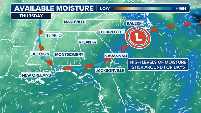
Southeast set for multiple days of rain.
(FOX Weather)
The front gets settled into place on Saturday, leading to a quiet morning, but thunderstorms will quickly develop during the afternoon in an arc around the edge of the cold front.
This setup will see the low country of South Carolina, southern Georgia, and most of Alabama see the bulk of the storm action.
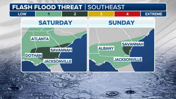
Flash Flood Threat this weekend in the Southeast.
After the system soaked parts of North Carolina on Friday, NOAA’s Weather Prediction Center shifted a Level 2 out of 4 flood risk south into South Carolina (including Charleston) and Georgia (including Savannah, Valdosta, and Albany), plus Jacksonville, Florida.

FOX Weather Correspondent Bayne Froney reports from Hilton Head, South Carolina which is facing a dayslong stretch of soggy weather and an increasing flood risk.
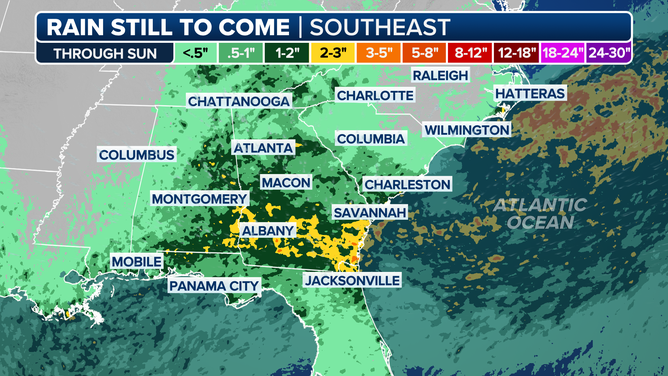
Up to 5 inches of rain with locally higher amounts of up to 7 inches could fall in this corridor through Sunday alone, the FOX Forecast Center says.
The work week won’t look much different than the weekend, and in fact the heavy rains will become more widespread.
An upper-level disturbance is forecast to slide back into the region from the east and stall across the Deep South, not only maintaining a feed of moisture, but energizing storms that do form.
The stubborn pattern will lead to 7–10 days of scattered thunderstorms dousing the Southeast, particularly Georgia and the western Carolinas.
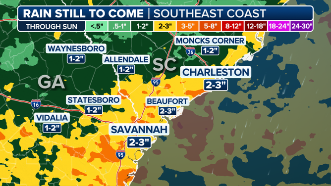
Savannah-Charleston Rain Forecast
Rainfall amounts are still uncertain, but there will be some continued risk of flooding that may increase as the week progresses and the rain totals pile up.
Silver lining to all the clouds: A big cool down
The skies may be gray, but perhaps a welcome trade-off is that all the high temperature maps have dropped out of the red.
Heat Alerts lingered across the Southeast on Friday as highs reached well into the 90s in cities like Atlanta, Savannah, Charleston and Charlotte and the heat index was well over 100 earlier with the persistent heat dome.
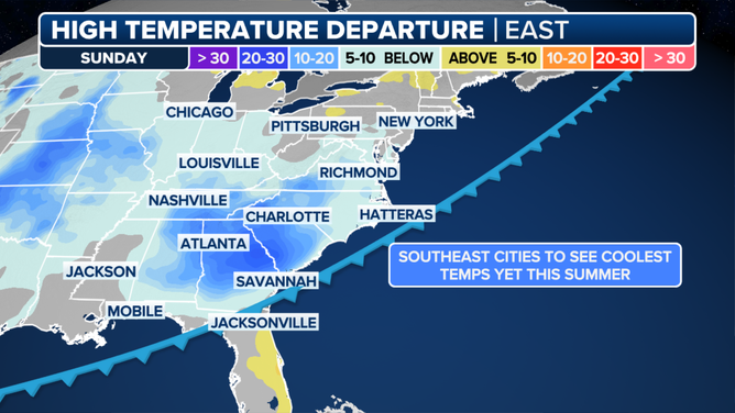
But with the potent cold front swinging through, many of those same areas will struggle to climb out of the 70s by Sunday — nearly 10 to 15 degrees cooler than average for this time of year.
Atlanta hasn’t experienced high temperatures in the low 70s since late May.
The ongoing wet pattern will likely keep most locations across Georgia and the Carolinas about 10 degrees below average through midweek.
Will the cooldown last into mid-August? Probably not.
The FOX Forecast Center says long-range guidance suggests much of the Eastern U.S. will trend at or above average for temperatures overall throughout the month.
Source link
editor's pick
latest video
Sports News To You
Subscribe to receive daily sports scores, hot takes, and breaking news!