Deadly flash flooding swamps I-95 corridor, prompting water rescues and states of emergency

A boy playing with a group of children was swept into a drainage pipe on Thursday evening and was later found deceased, the Mount Airy Volunteer Fire Company said.
NEW YORK – Dangerous flash flooding and water rescues took place along the Interstate 95 corridor on Thursday across the mid-Atlantic and Northeast, with a child reported being swept away by the dangerous currents.
The threat of flash flooding materialized early Thursday afternoon in Maryland with water rescues reported in the Joppatowne area of Harford County, north of Baltimore. By 2:15 p.m., between 2 and 4 inches of rain had fallen northeast of Baltimore, according to the National Weather Service Baltimore-Washington office.
An official with Maryland’s Mount Airy Volunteer Fire Company said the boy was playing with a group of children when he was swept into a drainage pipe. The victim was later pronounced dead at the scene.
The NWS estimated that between 4-6 inches of rain fell over the region, causing flash flooding of some creeks and streams.

Heavy rain poured into the Philadelphia Subway on Thursday during severe thunderstorms and flash flooding across the I-95 Corridor.
Interstates flood in New York City
New York Gov. Kathy Hochul declared a state of emergency for New York City and surrounding counties, encouraging employers to dismiss their employees early.
Dire warnings from officials in New York and New Jersey ahead of the storms were warranted on Thursday as traffic quickly became snarled around the New York metro region amid flash flooding, including major flooding on I-295 in Queens.

Parts of the Northeast are experiencing heavy rainfall today, as some roadways in New York City are flooded due to the wet weather. Footage shows a first responder checking in on a car stuck in the water.
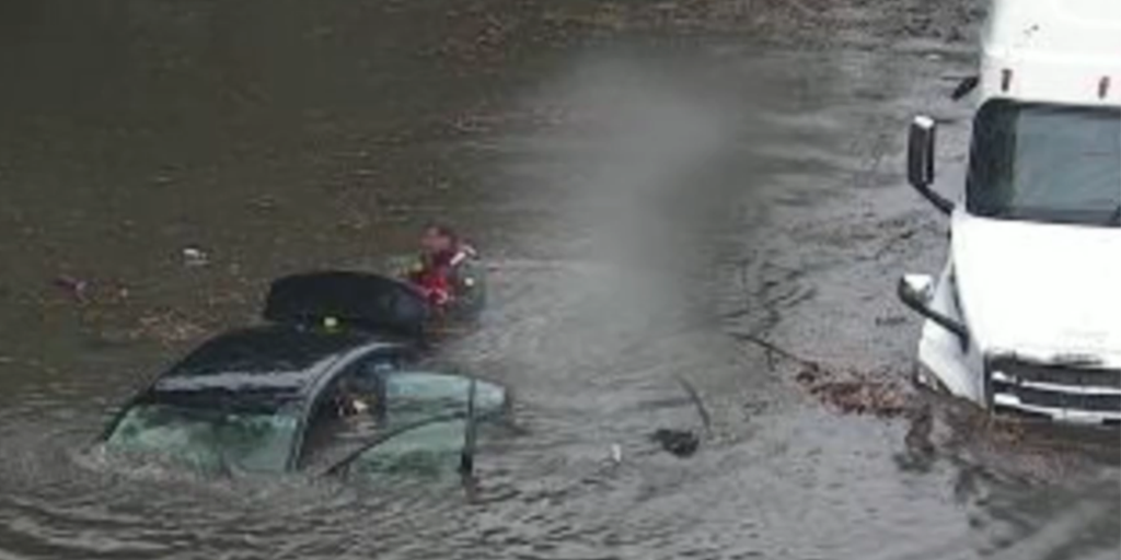
Video from New York DOT cameras showed two cars and a semi-truck stuck in floodwaters feet deep with rescues in progress. Radar estimates show about 5 inches of rainfall in the area early Thursday afternoon, according to the FOX Forecast Center.
New York Police reported all northbound lanes of FDR Drive at East Houston Street were also closed due to flooding.
Even the subways or the trains were not spared from impacts. New York City’s MTA reported delays on multiple subway lines, and water was pouring onto the platform and tracks along the Long Island Rail Road in Queens at Great Neck.
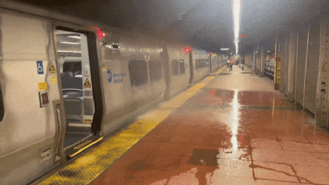
Heavy rains flood the 3:51 p.m. departure on the Hudson Line train leaving from track 38 in Grand Central Terminal in New York City on July 31, 2025.
(Chantal McLaughlin/TMX / FOX Weather)
The Long Island Rail Road service was suspended along some routes due to high water.
Video out of Queens showed firefighters assisting some passengers out of a train that was halted due to the severe weather.
The Metropolitan Transportation Authority said it suspended traffic in both directions on the Port Washington Branch due to flooding east of Flushing Main Street. Residual delays spilled into Friday morning’s commute.
“It’s been a difficult week for our subway riders,” said Hochul at a Friday afternoon news conference.
“Issues caused by the weather, whether it’s extreme heat or extreme weather causing torrential downpours, there have been disruptions at places throughout our system… And it’s frustrating,” Hochul continued, referring to subway power outages due to extreme heat just two days prior.

Heavy rains flood the 3:51 p.m. departure on the Hudson Line train leaving from track 38 in Grand Central Terminal in New York City on July 31, 2025.
(Chantal McLaughlin/TMX / FOX Weather)
Hochul said the MTA would conduct a full review of the disruptions this week. She said that there was sufficient funding to address the issue.
Meanwhile, similar delays with trains were reported between Philadelphia and Wilmington, where high water was reported to be covering the tracks.
“We are working to establish and provide a delay time. Once a route is available, anticipate residual delays. We appreciate your patience and apologize for any inconvenience caused,” Amtrak said in a statement.

Slow-moving thunderstorms on Thursday afternoon caused flooding across parts of New Jersey, Pennsylvania and New York. Video from South Amboy shows several cars driving through high floodwaters during the height of the storms.
Flooding spread into New Jersey, snarling traffic there, too. Water covered multiple lanes of I-280 in Orange, while cars were stuck in flooded roads in Elizabeth and Summit, according to NWS storm reports. U.S Highway 22 was covered in water in Plainfield.
Delays are also mounting at airports across the Northeast due to thunderstorms, including Philadelphia International Airport, John F. Kennedy International Airport, LaGuardia Airport, Newark Liberty International Airport and Boston Logan International Airport.
The flooding potential is expected to increase during the day as storms develop during the afternoon hours, some of which could be severe. A Severe Thunderstorm Watch is in place from Northern Virginia to New York City through Thursday night.
-

Water Rescue in Joppa, Maryland
(Joppa Magnolia Volunteer Fire Department) -

A flooded road near Joppatowne, Maryland in Harford County on July 31, 2025.
(Harford County Emergency Services) -

Harford County Fire and EMS boats responding to flooding on July 31, 2025.
(Harford County Fire and EMS) -
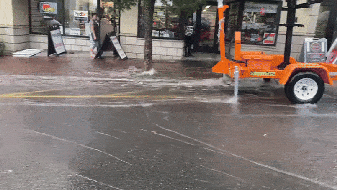
Flooding in Downtown South Orange, New Jersey on July 31, 2025.
( ) -

A rescuer reaches a car and semi-truck in flooding on I-295 in Queens, New York on July 31, 2025.
(NYDOT) -

Queens Flooding on I-295
(NYDOT) -

Queens Flooding on I-295
(NYDOT) -

Queens Flooding on I-295
(NYDOT) -

Pedestrians during a rainstorm in New York, US, on Thursday, July 31, 2025. New York City commuters are bracing for potential flooding from heavy rain Thursday, just hours after an unrelated power outage that continued to snarl subways late into the afternoon. Photographer: Victor J. Blue/Bloomberg via Getty Images
( ) -

In a file photo from July 13, 2024, a flash flood is seen on Brookville Boulevard near 147th Avenue in the Queens borough of New York City. Torrential rains caused rush-hour street flooding on Thursday in New York City. (Theodore Parisienne/New York Daily News/Tribune News Service via Getty Images)
( ) -

NEW YORK, NEW YORK – JULY 31: Storm clouds hover near Central Park on July 31, 2025 in New York City. Widespread storms swept across the Mid-Atlantic and Northeast on Thursday, bringing bursts of heavy rain. Forecasters warned that multiple rounds of storms could lead to a “potentially significant flash flooding event” in some areas. (Photo by Adam Gray/Getty Images)
( ) -

NEW YORK, NEW YORK – JULY 31: The Empire State Building is reflected in a window on July 31, 2025 in New York City. Widespread storms swept across the Mid-Atlantic and Northeast on Thursday, bringing bursts of heavy rain. Forecasters warned that multiple rounds of storms could lead to a “potentially significant flash flooding event” in some areas. (Photo by Adam Gray/Getty Images)
( )
After the latest forecast called for up to 7 inches of rain in some areas, New Jersey Acting Gov. Tahesha Way declared a state of emergency for all of New Jersey.
Flooding in Downtown South Orange, New Jersey on July 31, 2025.
“Beginning this afternoon, we are expecting severe thunderstorms to bring heavy rainfall and damaging wind gusts with the potential for flash flooding across the state,” Way said. “I urge all New Jerseyans to remain alert, follow all safety protocols, and monitor the proper channels for the duration of these storms. Residents should remain off the roads and indoors unless absolutely necessary.”
This latest flooding threat comes two weeks after deadly flooding claimed two lives in New Jersey when a vehicle was swept into a raging brook. During that storm, New York City experienced its second-wettest hour on record with 2.07 inches and shattering a 117-year-old daily record.

Towns across New Jersey are cleaning up damage from floods on Monday. in Bridgewater Township, homes were damaged, cars were flooded and roads were closed. Mayor Matthew Moench joins FOX Weather to give an update on recovery efforts.
Source link
editor's pick
latest video
Sports News To You
Subscribe to receive daily sports scores, hot takes, and breaking news!