Bryan Norcross: Atlantic remains hostile to tropical development – for now

FOX Weather is your Hurricane HQ.
(FOX Weather)
Updated at 8 a.m. ET on Wednesday, July 30, 2025
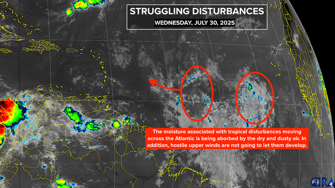
The tropical disturbance in the far eastern Atlantic has lost most of its moisture, and the going is going to stay rough. The steering flow is going to bend its track to the north where the air is very dry, the pressure is high, and the upper winds are hostile. The system is likely to continue to lose moisture.
There are actually two disturbances in a strung-out area of disturbed weather off the African coast. They are forecast to merge today and tomorrow with what’s left of their moisture and energy arriving in the vicinity of the northeastern Caribbean late tomorrow or Saturday. A slight moisture surge is all that’s expected in the Islands.
What happens next continues to be a bit of an open question. The most likely outcome is not much. But late next week we can’t rule out at least a tropical depression somewhere east of the Bahamas, although the latest computer forecasts indicate that the odds are low.
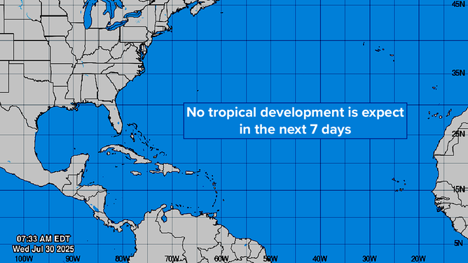
The National Hurricane Center continues to call for a quiet Atlantic, Caribbean, and Gulf for the next 7 days.
Another disturbance is in line behind this first significant one of the season. Long-range computer forecasts indicate that it will have a chance to develop. Each disturbance that comes along moistens the path across the tropical belt to some degree, and as we move into August, on average the Saharan dust will fade.
So we’ll just keep an eye on it.
In the Pacific
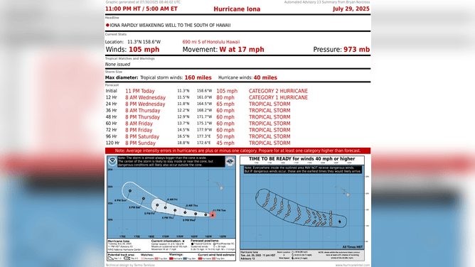
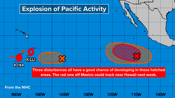
Mother Nature has gone crazy. There’s a hurricane, a tropical storm, and three more systems trying to develop. None of them are a threat to land for now, although a new storm forming off Mexico could track near Hawaii next week.
All this is very unusual, and there’s no obvious mechanism triggering it. The Eastern and Central Pacific are normally busy in El Niño years, when the equatorial waters there are unusually warm. That’s not the case this year.
There’s a small strip of water that’s slightly warmer than normal well south of Hawaii, and the named storms are threading that needle. It’s the overall atmospheric pattern that has to be extremely conducive to development.
(NHC / Bryan Norcross / NOAA)
The supportive factors appear to include the MJO, which is a pulse that slowly moves around the Earth from west to east. It alternately enhances and suppresses storm development. And there are other transitional factors involved.
The MJO forecasts indicate that it will be over the Atlantic around mid-August. That doesn’t mean that tropical development will suddenly explode. We don’t know how strong the pulse will be at that time, and whether the other factors will be enhancing development as well.
In any case, tropical activity normally ramps up in the middle of August. We’ll see if it suddenly switches on like it did in the Eastern Pacific early in the season and now again in both the Eastern and Central Pacific. That’s often the way it works.
(NHC / Bryan Norcross / NOAA)
Source link
editor's pick
latest video
Sports News To You
Subscribe to receive daily sports scores, hot takes, and breaking news!