
Today’s top weather news: Tropical threat lurks in Gulf as extreme heat intensifies for millions
FOX Weather has you covered with the breaking forecasts and weather news headlines for your Weather in America on Wednesday, July 23, 2025. Get the latest from FOX Weather Meteorologist Craig Herrera.
Welcome to the Daily Weather Update from FOX Weather. It’s Wednesday, July 23, 2025. Start your day with everything you need to know about today’s weather. You can also get a quick briefing of national, regional and local weather whenever you like with the FOX Weather Update podcast.
National Hurricane Center flags area to watch for possible tropical development as system soaks Gulf Coast
A storm system spinning off the southeastern U.S. coastline has caught the attention of the National Hurricane Center (NHC) with a small chance of developing into a tropical system.
Much like what was previously known as Invest 93L earlier this month, a trough of low pressure at the southern end of a frontal boundary is forecast to move west-southwestward into the north-central portion of the Gulf, according to the NHC. There, environmental conditions could allow for some slow development if the system remains far enough offshore.
In terms of rainfall totals, about 2–3 inches could fall across much of the northern Gulf Coast, with some locally higher amounts.
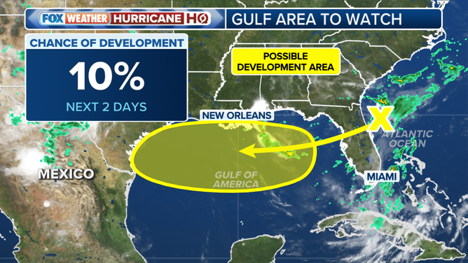
This graphic shows an area to watch for possible tropical development.
(FOX Weather / FOX Weather)
Nearly 100 million suffer under life-threatening heat alerts from Chicago to New Orleans
More than 97 million people are under life-threatening heat alerts from the South to the East Coast as a large ridge of high pressure builds over the central U.S. this week, commonly referred to as a heat dome.
The FOX Forecast Center said these systems act like a lid on the atmosphere, trapping heat and leading to prolonged periods of hot, dry weather. While this particular event may not break temperature records, it will still drive widespread highs into the upper 90s across a significant portion of the country.
With elevated dew points, the heat index or “feels-like” temperature is expected to exceed 100 degrees in major cities such as St. Louis, Kansas City and Oklahoma City. Some spots could feel closer to 110 to 115 degrees.
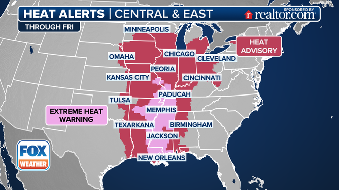
This graphic shows heat alerts through Friday, July 25, 2025.
(FOX Weather / FOX Weather)
Severe storms ride along northern edge of heat dome
Along the northern edge of that heat dome, fast-developing severe storms will fire up capable of producing damaging winds, large hail, and torrential rain. Some of these storms may be slow-moving, significantly increasing the risk of flash flooding, especially in areas that have already received heavy rainfall.
The first wave of storms is ongoing Wednesday morning, with a second, more intense round expected to begin Wednesday afternoon.
NOAA’s Storm Prediction Center has issued a Level 2 out of 5 risk of severe thunderstorms for an area from Northeastern Nebraska into Northern Michigan.
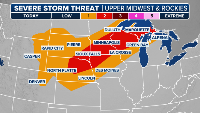
This graphic shows the severe weather threat for Wednesday, July 23, 2025.
(FOX Weather / FOX Weather)
See it: What is this UFO-shaped cloud doing over eastern China?
A UFO-shaped cloud created quite the dramatic scene over eastern China on Tuesday, with photographers and residents flocking to catch a glimpse of the unusual sight.
The cloud formation, known as a lenticular cloud, was photographed over Lianyungang in China’s Jiangsu province.

LIANYUNGANG, CHINA – JULY 22: Flying saucer-shaped cloud appears in the sky on July 22, 2025 in Lianyungang, Jiangsu Province of China.
(Geng Yuhe/VCG / Getty Images)
Before you go
Here are a few more stories you might find interesting.
Need more weather? Check your local forecast plus 3D radar in the FOX Weather app. You can also watch FOX Weather wherever you go using the FOX Weather app, at FOXWeather.com/live or on your favorite streaming service.
Source link
editor's pick
latest video
Sports News To You
Subscribe to receive daily sports scores, hot takes, and breaking news!