Bryan Norcross: Watching for Florida flooding, then chance of development in Gulf

FOX Weather is your Hurricane HQ.
(FOX Weather)
Updated at 9 a.m. ET, Monday, July 14, 2025
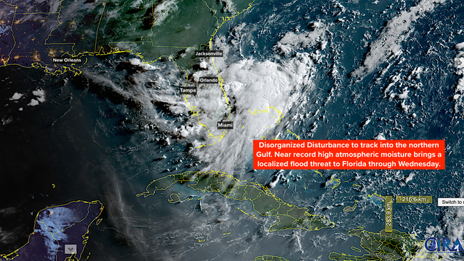
A disorganized disturbance off the east coast of Florida is forecast to bring heavy rain to the Florida Peninsula today into Wednesday. Flood Watches have already been issued for the metro areas in southeast Florida. Intense, slow-moving tropical downpours are likely with this system, which can cause local flooding in mostly flat Florida.
The system is starting out non-tropical, but has already tapped into deep tropical moisture, which it will drag over the peninsula. Widespread areas of 3 to 5 inches of rainfall are forecast, with some locations receiving 7 inches or more.
On Wednesday, the disturbance should begin tracking across the northern Gulf. The National Hurricane Center is giving it a chance of developing into at least a tropical depression as it tracks in the general direction of Louisiana — the odds are still in the low category.
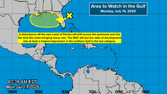
A disorganized disturbance off the east coast of Florida is forecast to bring heavy rain to the Florida Peninsula today into Wednesday.
(NOAA)
By Thursday or Friday, the center of the disturbance, if there is a center to track, should be near the north-central Gulf coast. It will still be carrying a mass of tropical moisture with it, so a long section of the coast and some inland sections will be impacted by heavy rain late in the week and into the weekend, if things play out as expected.
The consensus of the various computer forecasts, including the latest AI models, is that the system will be weak, but be broad and contain lots of moisture.
If the disturbance can organize to some degree over the Gulf, it is more likely to drag the moisture off the Florida Peninsula on Wednesday. If it stays broad and disorganized, however, the tropical moisture feed will continue to impact parts of the state. So the rain forecast for Florida on Wednesday is a bit up in the air. In any case, more typical summer weather should return.
If the disturbance can organize to some degree over the Gulf, it is more likely to drag the moisture off the Florida Peninsula on Wednesday.
(NOAA)
There is not a good consensus on how quickly the system will move past the Alabama, Mississippi, Louisiana coastal sections this weekend. As always, forecasts for poorly organized, or just developing systems carry more uncertainty than normal and are subject to change.
In Florida, it’s important that everyone pay attention to flood alerts that will likely be issued by the National Weather Service over the next couple of days. Have your FOX Weather app installed and updated, or be sure you have a way to know about any warnings that are issued.
Otherwise, the rest of the Gulf, the Caribbean, and the Atlantic continue to be hostile to tropical development, so no concerns there for now. Long-range projections show tropical disturbances becoming more robust in the tropical Atlantic next week, but nothing looks like a threat.
Source link
editor's pick
latest video
Sports News To You
Subscribe to receive daily sports scores, hot takes, and breaking news!