Today’s top weather news: Hurricane Erick to form soon as more severe storms threaten central US

FOX Weather has you covered with the breaking forecasts and weather news headlines for your Weather in America on Wednesday, June 18, 2025. Get the latest from FOX Weather Meteorologist Craig Herrera.
Welcome to the Daily Weather Update from FOX Weather. It’s Wednesday, June 18, 2025. Start your day with everything you need to know about today’s weather. You can also get a quick briefing of national, regional and local weather whenever you like with the FOX Weather Update podcast.
Hurricane conditions expected along Mexican coastline as Tropical Storm Erick intensifies
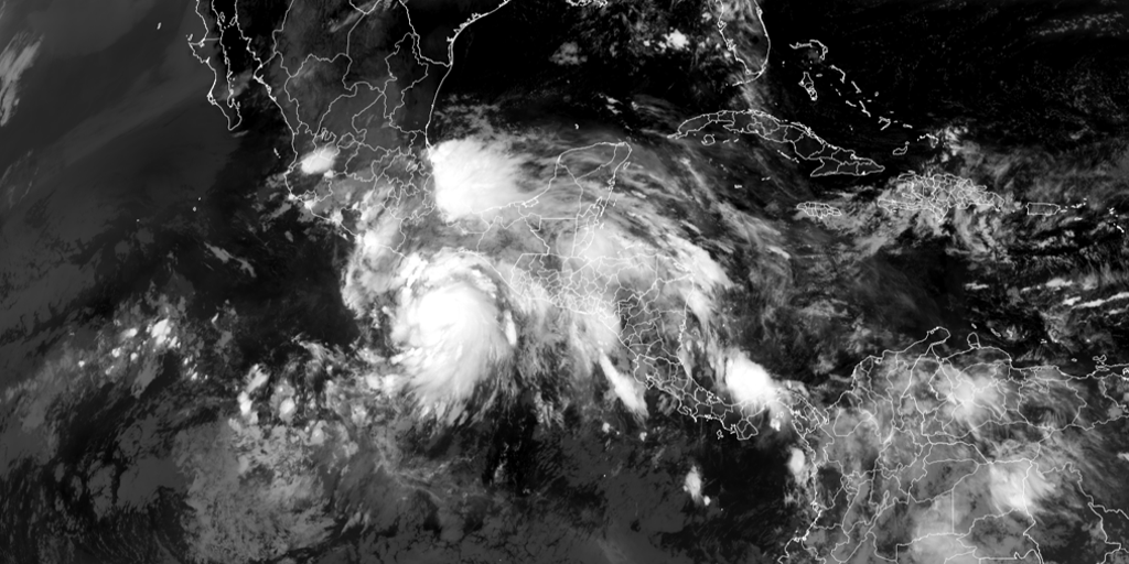
Tropical Storm Erick is strengthening in the Eastern Pacific Ocean some 180 miles south-southeast of Puerto Angel, Mexico, and is expected to rapidly intensify into a hurricane later Wednesday or early Thursday, according to the National Hurricane Center.
Erick is the fifth named storm of this year’s Eastern Pacific hurricane season, and it is expected to be the first named storm in either the Atlantic or Eastern Pacific basins to make landfall.
Mexico’s government has issued a Hurricane Warning from Puerto Angel to Acapulco, with other tropical weather alerts issued both south and north of the expected landfall location.
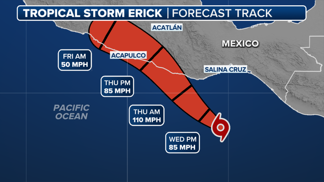
This graphic shows the expected track of Tropical Storm Erick.
(FOX Weather)
More than 98 million face severe weather threat Wednesday, including St. Louis, Indianapolis and Detroit
After severe storms rocked parts of the central Plains Tuesday with winds over 100 mph and hail, severe storms will threaten parts of the Midwest, Ohio Valley and Great Lakes region on Wednesday.
The Indianapolis metro area is under a Level 3 out of 5 risk of severe thunderstorms, while St. Louis and Detroit are included in a Level 2 out of 5 risk, according to NOAA‘s Storm Prediction Center.
Thunderstorms are expected to develop in the afternoon, bringing more damaging wind gusts and isolated hail, with a small chance of tornadoes covering northern Indiana and southern Michigan.
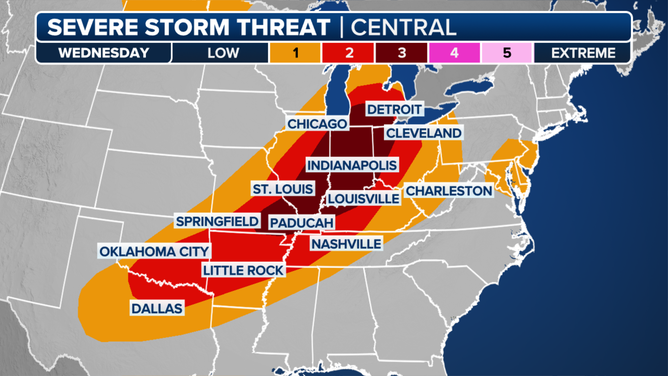
This graphic shows the severe weather threat for Wednesday, June 18, 2025.
(FOX Weather)
Critical fire weather threat for Southwest before 100-degree feels-like temperatures shift east
Low humidity, strong wind gusts and scorching temperatures have prompted Fire Weather Warnings for parts of Utah, Colorado, New Mexico and eastern Arizona.
Temperatures are forecast to be over 110 degrees in Las Vegas and Phoenix as summer starts to settle into the Southwest.
These triple-digit temperatures will shift east into the Plains, mid-Atlantic and Northeast in the form of a dangerous heat wave starting on Friday, just in time for the start of astronomical summer.
Watch this: Wichita slammed with storms packing vivid lightning, flooding rain
Dramatic video recorded in Wichita, Kansas, shows a man inside his car outside a business as a powerful thunderstorm unleashes torrential rain, vivid lightning and thunder on Tuesday.
The severe weather was part of a powerful storm system that raced across the Plains, producing hurricane-force wind gusts and baseball-sized hail.

A dramatic video recorded in Wichita, Kansas, shows a man inside his car outside a business as a powerful thunderstorm unleashes torrential rain, vivid lightning and thunder on Tuesday, June 17, 2025.
Before you go
Here are a few more stories you might find interesting.
Need more weather? Check your local forecast plus 3D radar in the FOX Weather app. You can also watch FOX Weather wherever you go using the FOX Weather app, at foxweather.com/live or on your favorite streaming service.
It’s easy to share your weather photos and videos with us. Email them to weather@fox.com or add the hashtag #FOXWeather to your post on your favorite social media platform.
Source link
editor's pick
latest video
Sports News To You
Subscribe to receive daily sports scores, hot takes, and breaking news!