Forecasters expect an active hurricane season, but history says otherwise
FOX Weather Hurricane Specialist Bryan Norcross explains what led to the latest hurricane forecast from Colorado State University. Norcross warns the current quiet spell does not mean a quiet hurricane season ahead.
MIAMI – The 2025 hurricane season is off to a busy start in the eastern Pacific, with three tropical cyclones already having developed before a single named system has formed in the Atlantic, which could be an indicator of what lies ahead.
Since reliable record-keeping on hurricane seasons began in the late 1960s, there have been less than two dozen years in which three or more named storms developed in the eastern Pacific before the Atlantic recorded its first.
This occurrence happens about once every four years and can take place regardless of the status of the El Niño–Southern Oscillation or what is commonly referred to as the ENSO.
In more than 84% of the seasons where three or more named storms formed in the eastern Pacific before the Atlantic, the Atlantic basin failed to end the year with more activity than its eastern Pacific counterpart.
The only seasons where the Atlantic was able to overtake the Pacific was during a La Niña or a Modoki El Niño cycle – neither of which are in control of weather patterns in 2025.
These years were 1998, 2004 and 2010, with only the latest occurrence flipping the script in any meaningful way.
Notably, when the eastern Pacific has produced more than four named storms before the Atlantic has even managed one, the Atlantic basin has never gone on to surpass the Pacific in total activity during the season.

Comparing the Atlantic and Pacific hurricane seasons.
(FOX Weather)
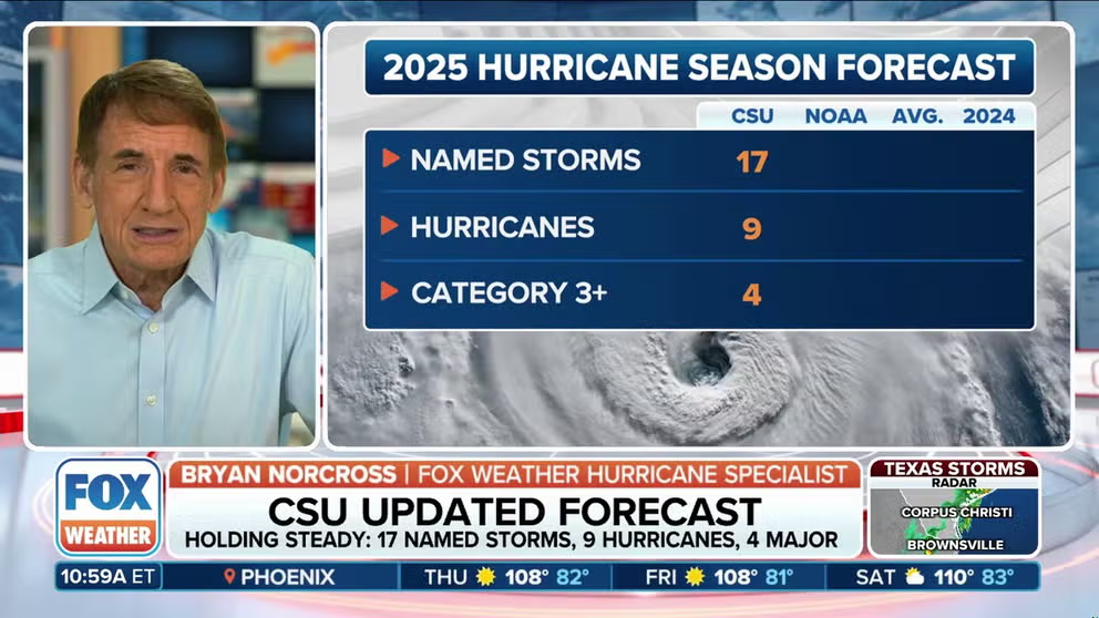
Despite the historical precedent over nearly the last 60 years, forecasters at Colorado State University are betting against the odds this year.
In the organization’s latest outlook for the Atlantic basin, forecasters expect 17 named storms to form, with nine becoming hurricanes and four of those strengthening to major hurricane status – which would be a busier than an average season if the prediction turns out to be accurate.
If the outlook holds true, 2025 would be in the running for being the only season with the world in a neutral status of the ENSO where the Atlantic overtakes the eastern Pacific in terms of activity.
“The team bases its forecasts on a statistical model, as well as four models that simulate recent history and predictions of the state of the atmosphere during the coming hurricane season,” CSU stated in its recent release.
FOX Weather Hurricane Specialist Bryan Norcross analyzed the latest outlook from CSU and had some words of caution for those wanting to edge the prediction into stone.
“…there is more uncertainty than normal in these numbers because nothing is really pushing the season any which way. All these signals are very weak. When signals are weak, then if something is just teeter tottering, it can tip over, you know. So, we wouldn’t be surprised to see this forecast be wrong,” Norcross stated.
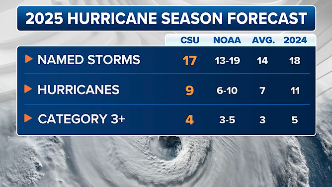
Colorado State University tropical season forecast
(FOX Weather)
HURRICANE SEASON 2025: HERE ARE THE NAMES FOR STORMS YOU’LL SEE THIS SEASON
Factors impacting the Atlantic season
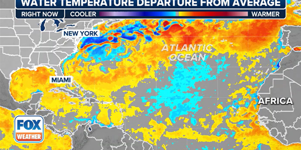
Pools of warmer and colder water temperatures across the Pacific and Atlantic will play a major role in shaping what unfolds across both basins during the next five months of the tropical cyclone season.
Currently, a neutral signal – commonly referred to as “La Nada“- is in place, which can lead to wide variability in how active the season becomes, but it’s the localized pockets of above- or below-normal sea surface temperatures that can make a difference.
For instance, in the eastern Pacific, the warmest waters are located along the coasts of Central America and southern Mexico, which has supported the formation of Alvin, Barbara and Cosme, with Dalila and Erick waiting in the wings.
These cyclones have not maintained strength for long due to a vast pool of cold water stretching from the Baja Peninsula to Hawaii and extending southward toward the equator.
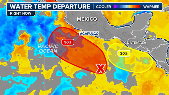
Water temperature departure from normal on 6/11/2025
(FOX Weather)
It’s this combination of warm and cold pools that has led NOAA and other global agencies to declare that a neutral phase, known as a La Nada, is currently underway.
If one of these anomalies gains dominance, either a La Niña or El Niño could emerge, but such a shift is not expected to occur until after the peak of the hurricane season has passed.
In the Atlantic, several conflicting pockets of sea surface temperatures are at play – many of which are known to suppress cyclone activity.
Forecasters are paying close attention to the Atlantic’s Main Development Region, which has generally remained at or just below average, the extremely warm waters of the northern Atlantic and a small but impactful phenomenon called the Atlantic Niña, which tends to reduce sea temperatures near the African coast.
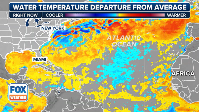
Atlantic water temperature departure from average
(FOX Weather)
As of now, none of these features appear to be producing favorable conditions for enhanced tropical cyclone formation, meaning if there is an error in the tropical seasonal forecasts, it likely leans toward overestimating storm activity versus underestimating.
One area of notable concern lies in the exceptionally warm waters of the Gulf and the Caribbean. If a cyclone were to enter these regions, conditions would likely exist for rapid intensification and development.
Source link
editor's pick
latest video
Sports News To You
Subscribe to receive daily sports scores, hot takes, and breaking news!