Dallas threatened by storms packing destructive 80-100 mph wind gusts, 5-inch hail

Millions of people in Texas and Oklahoma are bracing for severe weather on Sunday, with storms capable of producing destructive, hurricane-force wind gusts, massive hail and even some tornadoes. FOX Weather Meteorologists Michael Estime and Haley Meier break down the forecast on June 8, 2025.
Fast Facts:
- Destructive storms with 80-100 mph wind gusts and up to 5-inch hail expected in the southern Plains.
- Tornadoes may be embedded within the main line of storms on Sunday.
- Severe weather threat in Texa and Oklahoma upgraded to Level 4 out of 5.
DALLAS – Millions of people in Texas and Oklahoma, including the Dallas–Fort Worth Metroplex, will need to be on alert Sunday as the southern Plains braces for powerful storms packing destructive, hurricane-force wind gusts, massive hail and even some tornadoes.
-

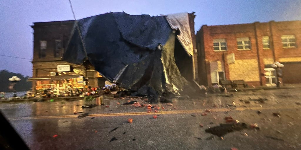
Apparent tornado damage in McAlester, Oklahoma, on June 7, 2025.
(Derrick James / @dljames0001 / X) -

Apparent tornado damage in McAlester, Oklahoma, on June 7, 2025.
(Derrick James / @dljames0001 / X) -

Apparent tornado damage in McAlester, Oklahoma, on June 7, 2025.
(Derrick James / @dljames0001 / X) -

Apparent tornado damage in McAlester, Oklahoma, on June 7, 2025.
(Derrick James / @dljames0001 / X) -

Apparent tornado damage in McAlester, Oklahoma, on June 7, 2025.
(Derrick James / @dljames0001 / X) -

Apparent tornado damage in McAlester, Oklahoma, on June 7, 2025.
(Derrick James / @dljames0001 / X) -

Apparent tornado damage in McAlester, Oklahoma, on June 7, 2025.
(Derrick James / @dljames0001 / X)
The renewed threat comes after deadly storms barreled across portions of Mississippi and Georgia, and an apparent tornado left a trail of damage across McAlester, Oklahoma, on Saturday.
Now, the FOX Forecast Center said that Sunday has the chance to be a “very significant severe weather day.”
DOWNLOAD THE FREE FOX WEATHER APP

(FOX Weather)
NOAA’s Storm Prediction Center (SPC) has upgraded the severe weather threat in portions of the south-central U.S. on Sunday to a Level 4 risk on its 5-point severe thunderstorm risk scale.
This upgraded threat includes more than 6 million people in cities like Dallas, Fort Worth, Arlington, Plano and Garland in Texas.
More than 5 million people in cities like Oklahoma City and Norman in Oklahoma, as well as Lubbock, Amarillo and Abilene in Texas are in a Level 3 out of 5 risk.
WATCH VS. WARNING: HERE ARE THE DIFFERENCES BETWEEN THESE WEATHER TERMS THAT COULD SAVE YOUR LIFE

(FOX Weather)
The FOX Forecast Center said that while there is a tornado threat on Sunday, the bigger threat will be destructive wind gusts between 80 and 100 mph within the main line of the storms. That’s because strong winds aloft in the mid-levels of the atmosphere will exist.
A pocket of cooler air will also be in place, which will then help some of the significant wind gusts reach the surface. The dense, cooler air, along with torrential rain, will serve as the pathway for the winds to work toward the ground.
HOW PUBLIC SAFETY OFFICIALS NOTIFY YOU DURING SEVERE WEATHER EMERGENCIES

Hail size representation.
(FOX Weather)
In addition, the SPC said that hail up to 5 inches, which is larger than a grapefruit, is also possible.
The FOX Forecast Center said that the timeline for the storms to begin to fire up will likely be in the afternoon hours on Sunday, with storm activity peaking in the late afternoon and early evening.
Supercell thunderstorms are likely in Oklahoma and Texas, and the wide coverage of storms will then eventually form into a potentially intense mesoscale convective system (MCS).
Source link
editor's pick
latest video
Sports News To You
Subscribe to receive daily sports scores, hot takes, and breaking news!