
New area to watch joins Invests 91E, 92E in busy eastern Pacific tropics as Barbara looms
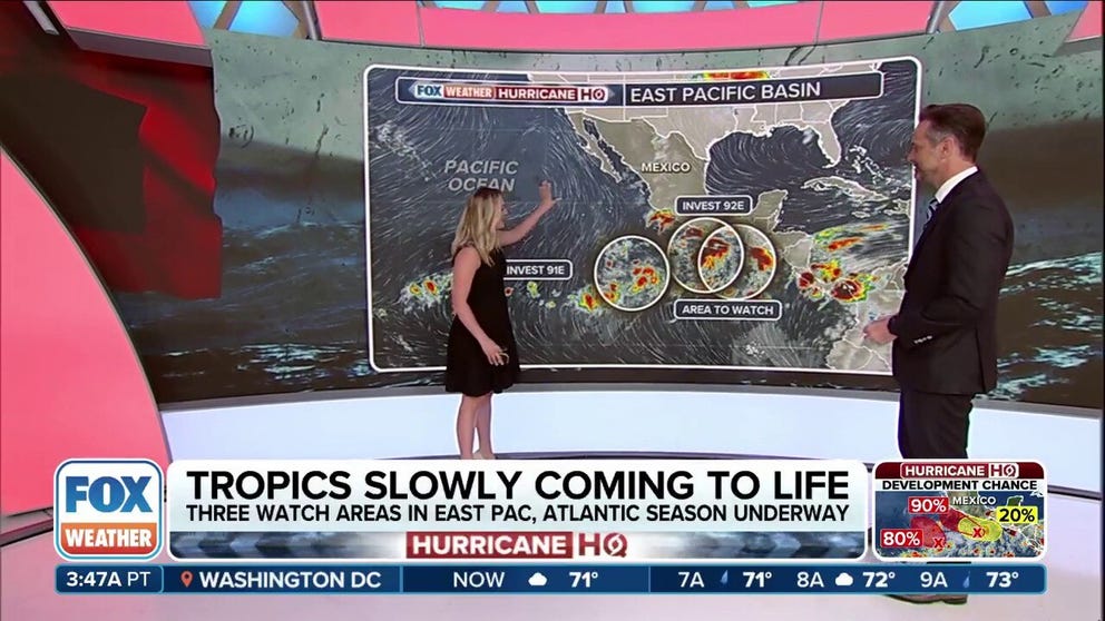
The NHC is now monitoring three areas off the western Mexico coast that could see tropical development in the coming days, including Invests 91E and 92E that could become at least a tropical depression by the end of the weekend.
A busy start to the hurricane season in the eastern Pacific Ocean got even busier Saturday morning as the National Hurricane Center has now added a third area to watch for possible tropical development.
But in the short term, two clusters of thunderstorms are on the cusp of becoming the basin’s next named storms, but which area of disturbed weather will take the name Barbara remains somewhat of an open question.
Both thunderstorm clusters were designated as invests on Friday as they parallel or slowly drift away from the Mexican coastline.
The National Hurricane Center first designated the batch of developing thunderstorms farther away from the southwestern Mexican coast as Invest 91E on Friday. A few hours later, the cluster closer to the coast became Invest 92E.
An “invest” designation signals an area of heightened interest and allows the National Hurricane Center to run a collection of specialized datasets and computer forecast model guidance on that area of disturbed weather. These computer models simulate the system’s projected track possibilities and predict its future intensity.
SAHARAN DUST MUDDIES FLORIDA SKIES BEFORE EYEING GULF COAST, TEXAS
WHAT IS AN INVEST DURING HURRICANE SEASON?
Both 91E and 92E have a near-certain chance of developing into a tropical system over the weekend.
Invest 91E organized somewhat quickly and is expected to see continued gradual development. The NHC says a tropical depression is likely to form over the weekend or early next week while the system moves northwestward at about 10 mph.

(FOX Weather)
It has a 70% chance of tropical development over the weekend.
WHAT IS AN INVEST DURING HURRICANE SEASON?
Invest 92E, located several hundred miles southwest of the Gulf of Tehuantepec, could potentially have impacts on Mexico’s southwestern coast with rounds of heavy rains and high surf.

(FOX Weather)
“Environmental conditions are conducive for further development, and a tropical depression or tropical storm is expected to form this weekend as the system moves west-northwestward at 10 to 15 mph,” NHC forecasters said.
Invest 92E has an 80% chance of development over the weekend and thunderstorm activity has increased on the disturbance’s eastern side, according to the Hurricane Center.
The next name on the list is Barbara. If both manage to form into a tropical storm, the latter one would be named Cosme.
Finishing out the trio, a new area to watch was tagged by the NHC on Saturday morning as an area of low pressure is forecast to develop late next week south of southern Mexico.
The NHC says conditions appear conducive for some gradual development of this system as it moves west-northwestward, but as of now just has a low chance of development over the nest week.

(FOX Weather)
Tropical activity has been increasing in the basin since the start of the hurricane season on May 15.
Tropical Storm Alvin formed and quickly dissipated last week.
WATCH: DRONE VIDEO SHOWS GIANT WAVE SWALLOWING UP SWIMMERS ON MEXICAN BEACH
Source link
editor's pick
latest video
Sports News To You
Subscribe to receive daily sports scores, hot takes, and breaking news!