Severe weather threatens Kentucky to Tennessee Valley days after deadly outbreak

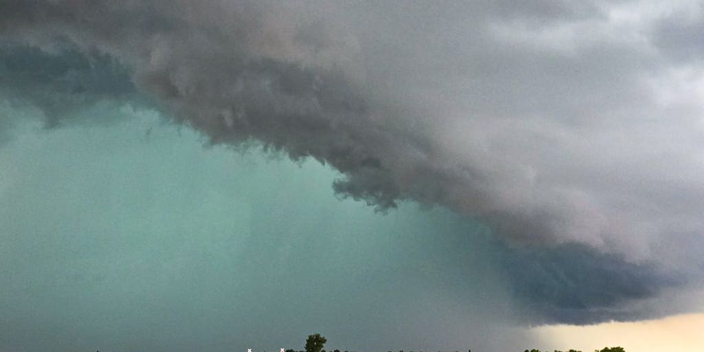
Thunderstorms are ongoing across Arkansas and Indiana on Tuesday morning. Storms are expected to develop across the Tennessee Valley Tuesday afternoon. All modes of severe weather are possible in association with this system including tennis ball-sized hail, damaging wind gusts and strong tornadoes.
Fast Facts
- The lower Ohio Valley, Tennessee Valley, mid-South and Deep South could see multiple rounds of severe weather Tuesday.
- Kentucky and Tennessee face the risk of strong tornadoes beginning Tuesday afternoon.
- Damaging wind gusts of up to 75 mph and flash flooding are also a significant threat.
LEXINGTON, Ky. – Nearly 60 million people in the central and southern U.S. are once again under threat of severe weather Tuesday, including most of Kentucky, which just endured a tornado outbreak last Friday that claimed at least 19 lives in the state. This is part of a relentless eight-day severe weather pattern that began last Wednesday for the middle of the country.
Tuesday’s threat is centered on Kentucky, Tennessee, eastern Arkansas, northern Mississippi and northern Alabama, where a volatile atmosphere will allow strong thunderstorms to develop beginning in the mid-afternoon, bringing all modes of severe weather, including large hail, damaging wind gusts and the possibility of strong tornadoes (EF-2 or higher).
A broad area covering the lower Ohio Valley, Tennessee Valley, mid-South and Deep South is expected to see multiple rounds of strong thunderstorms, which will track into the region from the west throughout the afternoon and into the evening.
LONDON, KENTUCKY, TORNADO SURVIVORS PILED INTO BATHTUBS, EMERGED TO FIND EVERYTHING GONE
-

LONDON, KENTUCKY – MAY 18: Debris floats in a pool near a severely damaged house on May 18, 2025 in the community of Sunshine Hills outside of London, Kentucky. A tornado struck the neighborhood of Sunshine Hills just after midnight on May 17, 2025 in London, Kentucky.
(Michael Swensen) -

LONDON, KENTUCKY – MAY 18: Debris floats in a pool near a severely damaged house on May 18, 2025 in the community of Sunshine Hills outside of London, Kentucky. A tornado struck the neighborhood of Sunshine Hills just after midnight on May 17, 2025 in London, Kentucky.
(Michael Swensen) -

LONDON, KENTUCKY – MAY 17: Members from a local church pray with Tony and Joe McFall, who lost their father and step-mother during the tornado in the neighborhood of Sunshine Hills on May 17, 2025 in London, Kentucky. A tornado struck communities in Somerset and London, Kentucky, leaving over 10 dead and more injured. (Photo by Michael Swensen/Getty Images)
( ) -

Debris is seen on a damaged car after a tornado hit in London, Kentucky on May 17, 2025. Severe storms that swept through the US states of Missouri, Kentucky and Virginia left more than 25 people dead, laying waste to local communities and cutting off electricity to nearly 200,000, authorities said on May 17. Kentucky Governor Andy Beshear said on X at least 18 people had died in the storms Friday night, while local officials in Missouri said another seven were dead there. (Photo by Allison Joyce / AFP) (Photo by ALLISON JOYCE/AFP via Getty Images)
( ) -

A US flag is seen on a destroyed car after a tornado hit in London, Kentucky on May 17, 2025. Severe storms that swept through the US states of Missouri, Kentucky and Virginia left more than 25 people dead, laying waste to local communities and cutting off electricity to nearly 200,000, authorities said on May 17. Kentucky Governor Andy Beshear said on X at least 18 people had died in the storms Friday night, while local officials in Missouri said another seven were dead there. (Photo by Allison Joyce / AFP) (Photo by ALLISON JOYCE/AFP via Getty Images)
( ) -

Debris and damaged homes are seen after a tornado hit in London, Kentucky on May 17, 2025. Severe storms that swept through the US states of Missouri, Kentucky and Virginia left more than 25 people dead, laying waste to local communities and cutting off electricity to nearly 200,000, authorities said on May 17. Kentucky Governor Andy Beshear said on X at least 18 people had died in the storms Friday night, while local officials in Missouri said another seven were dead there. (Photo by Allison Joyce / AFP) (Photo by ALLISON JOYCE/AFP via Getty Images)
( )
Thunderstorms with strong winds were ongoing across Arkansas and Louisiana on Tuesday morning.
A powerful upper-level system, responsible for driving much of Tuesday’s storms, is also drawing in very moist air across the central and eastern U.S., creating a flash flood threat.
Storms will track from Missouri through Illinois and Indiana during the day, before moving into parts of Kentucky and the Ozarks. This system will eventually sweep across the Tennessee Valley by Tuesday evening.
NOAA’s Storm Prediction Center has issued a Level 3 out of 5 risk of severe thunderstorms for Kentucky, Tennessee, eastern Arkansas, northern Mississippi and northern Alabama. Small slivers of southeastern Missouri, southern Illinois, northwestern Georgia and southwestern North Carolina are under that same threat level, as well.
TORNADOES DAMAGE HOMES IN ARKANSAS, OKLAHOMA AS SEVERE WEATHER TEARS ACROSS CENTRAL US

(FOX Weather)
Kentucky to Tennessee Valley threatened by more strong tornadoes
The greatest risk of strong tornadoes (EF-2 or higher) will be centered over storm-weary Kentucky, as well as Tennessee, eastern Arkansas, northern Mississippi and northern Alabama, covering cities like Memphis, Nashville and Knoxville in Tennessee, Lexington in Kentucky and Birmingham in Alabama.
London, Kentucky, which was one of the hardest-hit areas by Friday’s tornado outbreak, is very close to the area at risk of strong tornadoes.

London, Kentucky, was severely impacted by last weekend’s tornado outbreak, and now bracing for another round of severe storms as a new system threatens vulnerable parts of the Bluegrass State on Tuesday. FOX News Multimedia Reporter Chelsea Torres is on the ground in London with the latest.
Kentucky Gov. Andy Beshear warned people who use NOAA radio for their weather alerts that the service will be down for the next several days.
The National Weather Service said on its website that this is part of a “necessary scheduled system update.”
Conditions will become favorable for damaging wind gusts and potential tornado development beginning in the afternoon.
“This is going to come in with straight-line winds,” FOX Weather Meteorologist Britta Merwin said. “Not only are you going to have the chance for tornadoes, but you could have wind gusts of up to 70 mph.”
Merwin also highlighted that Nashville, Tennessee, could have two rounds of significant thunderstorms, one around dinnertime and the other after sunset.
She cautioned that nighttime tornadoes will be possible.
NIGHTTIME TORNADOES FAR MORE LIKELY TO TURN DEADLY THAN DAYTIME ONES

(FOX Weather)
Kentucky, Tennessee also face flash flood threat
Tuesday’s storms will also bring heavy rain to central and southern Illinois, Indiana and Kentucky, where widespread totals of 1-2 inches are expected, with locally higher amounts exceeding 3 inches.
This rain could hamper tornado recovery efforts in Kentucky.
NOAA’s Weather Prediction Center has issued a Level 2 out of 4 flash flood threat for portions of Illinois, Indiana, Ohio, Virginia, West Virginia, Kentucky and Tennessee.

(FOX Weather)
Source link
editor's pick
latest video
Sports News To You
Subscribe to receive daily sports scores, hot takes, and breaking news!