Renewed severe weather outbreak threatens over 140 million with strong tornadoes, extreme gusts

An outbreak of severe storms is likely Friday afternoon into the evening across the Ohio, Mississippi and Tennessee valleys. A Level 4 out of 5 severe storm threat is in place with all severe threats being likely, including strong tornadoes, giant hail and extreme wind gusts.
PADUCAH, Ky. – Another significant severe weather outbreak is unfolding across the Midwest and Ohio Valley on Friday, placing more than 143 million people under alert.
This comes following a turbulent Thursday that saw over a dozen tornado reports, more than 135 damaging wind incidents and over 90 reports of large hail across the Upper Midwest. The threat of these dangerous conditions is expected to persist and potentially intensify into early next week.
LIVE STORM TRACKER: SEVERE WEATHER MAPS, RADAR, HAIL POTENTIAL, TORNADO THREATS, AND MORE
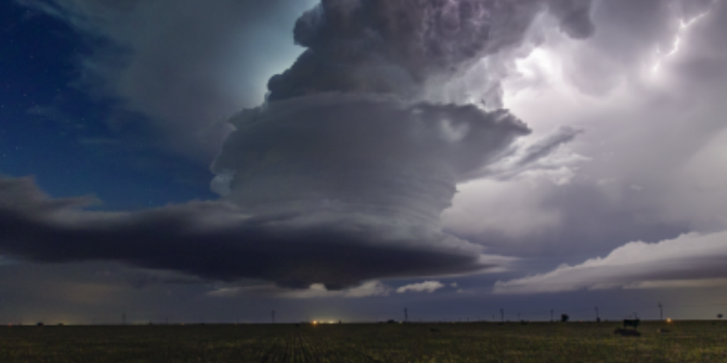
Storm spotters around New Richmond, Wisconsin, outside the Twin Cities, spotted a rope-like tornado on Thursday.
A first round of severe storms is actively being tracked across Kentucky, Illinois, Indiana and Arkansas on Friday morning. These storms threaten quarter-sized hail and damaging winds. In Arkansas, a particularly potent supercell thunderstorm is racing northeast at 55 mph, capable of producing winds exceeding 50 mph, the FOX Forecast Center said.

(FOX Weather)
However, the most significant concern for Friday lies in the afternoon and evening hours, where NOAA’s Storm Prediction Center has issued a Level 4 out of 5 risk of severe weather, particularly for southern Illinois, Indiana and Kentucky.
This “bull’s-eye” region faces a high potential for strong tornadoes, possibly EF-2 or stronger, and there is a possibility for a “high-end long-track tornado.”
“We’re not even talking about just the potential for tornadoes forming, but some of the tornadoes could be particularly strong, producing winds that are well over 115 mph,” FOX Weather Meteorologist Britta Merwin said.
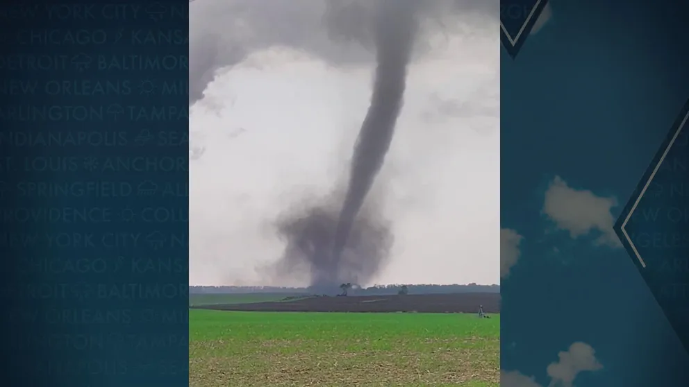
WATCH: TORNADOES, HAIL SPOTTED AS SEVERE STORMS TEAR ACROSS MINNESOTA, WISCONSIN

(FOX Weather)
As the day progresses, storm coverage will continue to become more widespread, and several clusters will move east. The FOX Forecast Center notes that during the evening hours, several “bow echoes” will move through the northern Tennessee Valley, resulting in extensive wind damage in swaths with widespread wind gusts potentially exceeding 75 mph.
Large hail remains a threat as well, potentially reaching the size of golf balls to softballs.
A Level 2 out of 4 flash flood risk also exists, as intense rainfall rates could overwhelm already saturated soils.
Severe storm threat moves into east Saturday; new wave emerges next week
If storms can maintain their strength overnight, they could impact parts of the mid-Atlantic and Northeast on Saturday. Damaging wind gusts look to be the largest threat, the FOX Forecast Center said.
With graduation ceremonies and the end of the school year approaching for many in the central Plains, all eyes will be on the sky well past the weekend.
SEE IT: HUGE WALL OF DUST LOOMS OVER NEBRASKA FIELD

(FOX Weather)
Another wave of severe weather will move across the central U.S., and the Storm Prediction Center has issued a severe weather outlook extending through early next week.
While Sunday offers a slight reprieve for the currently impacted areas, a Level 3 risk for severe weather, including Oklahoma City and Wichita Falls, is already in place. A further upgrade to this threat level is expected by Sunday.
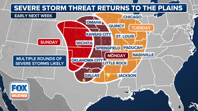
This graphic shows a severe weather threat starting on Sunday, May 18.
(FOX Weather)
By Monday, the severe weather threat will expand across a large portion of the central Plains, from Omaha, Nebraska, southward through Dallas-Fort Worth. This system is expected to progress eastward, bringing the potential for severe storms back into areas like Paducah, Kentucky, by Tuesday.
“This is a classic severe weather setup for the Central Plains,” Merwin said. “You have all of that moisture streaming in from the Gulf, the cooler, drier air off the Rockies, and then you get that classic clash zone.”
Source link
editor's pick
latest video
Sports News To You
Subscribe to receive daily sports scores, hot takes, and breaking news!